Elsewhere in Weather News: November 8th, 2014

Super Typhoon Nuri Transitions into Strong Extratropical Storm

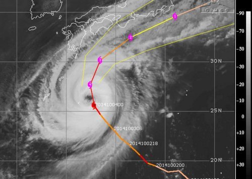
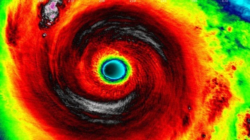
The Western Pacific continued to be active this past week, spinning up yet another violent storm, which thankfully remained at sea and did not impact land. Nuri formed late last week west of Guam and slowly drifted west-northwest. It organized itself as conditions became ideal for strengthening of the typhoon: sea surface temperatures were very warm and wind shear was low. Nuri became a super typhoon last weekend as it deepened to a central pressure of 910mb and brought estimated sustained winds of 285km/h – similar conditions to what super typhoon Vongfong had at its peak this past October. Up to date, these two are tied for the strongest tropical storm of 2014. Nuri quickly curved Poleward before reaching Japan, sparing the Japanese islands from the storm.

IR satellite image of Nuri as it held super typhoon strength this past Sunday/Monday. (Source: Soumi NPP VIIRS)

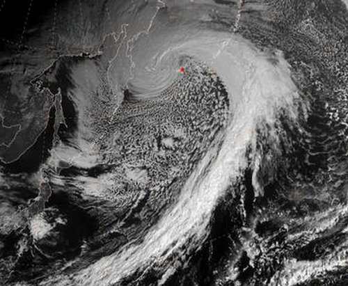
Nuri did not end there, however. As it got captured by the polar jet stream, it transitioned into an extratropical storm. Extratropical storms are the low pressure systems that we see across the mid-latitudes, including here in Manitoba. They have significant differences from their tropical brethren, the most significant being that extratropical storms have warm and cold fronts that generate energy for the storm, as opposed to tropical systems that have generally uniform temperature. As the remnants of Nuri transitioned into the Polar Jet they strengthened once again, aided by a strong temperature gradient aloft.[1] Projected wave heights on the Bering Sea neared 50 feet as the storm “bombed” out[2] on Friday to a minimum pressure of 927mb. Extremely strong winds were recorded on the Aleutian Islands, where gusts exceeded 150km/h.

Satellite picture of the remnants of Nuri as an extratropical storm on Friday.

The remnants of Nuri are expected to continue moving towards Alaska but weaken significantly by the time they reach the Alaskan shores, as the low pressure system enters its weakening phase.

Alaskan Bomb Results in Arctic Outbreak over Central & Eastern North America

The intense storm over the Aleutian Islands is also indirectly responsible for the outbreak of cold air expected in the coming week over much of North America. As the system intensifies over the Aleutian islands, a strong upper-level ridge will build over the west coast of North America which will cause a resultant upper level trough to deepen over the remainder of the continent.

The GDPS shows prominent ridging over the west coast of North America, resulting in a deep upper-level trough over central & eastern North America.

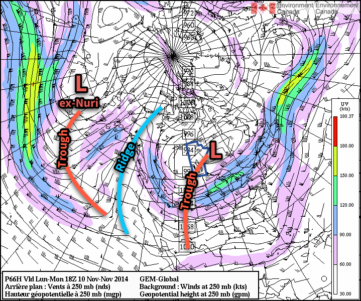
The deep upper-level trough will allow the cold air that’s been bottled up in the Arctic to spill southwards, resulting in well below seasonal temperatures across a significant portion of Eastern North America. The developing upper-level pattern is a fairly stable configuration for the flow, so no significant changes will likely occur in the next week or two other than gradual moderation.


  1. The strong temperature gradient was easily evident by a very strong jet streak of over 130 knots – that’s over 240km/h – at 500mb!  ↩
  2. A system has “bombed” when its central pressure drops 24mb or more in 24 hours.  ↩

Elsewhere in Weather News: October 11th, 2014

Two Dangerous Storms Spin Up

Notable activity has expanded from the tropical waters of the Western Pacific into the Bay of Bengal over the past week. We mentioned in last week’s EIWN that typhoon Vongfong could be a threat to Japan sometime this week – this has since become a reality. Formerly known as super typhoon Vongfong, typhoon Vongfong took aim at the Japanese island of Okinawa early this morning. Packing sustained winds of 140km/h which gusted to over 200km/h, the storm caused power outages to 27,000 residents and some locations on the island reported over 200mm of rain.

News agencies in the region report 20 injuries as of Saturday morning but thankfully no deaths from the storm. Vongfong is expected to curve northeast and slowly transition to an extratropical storm, but not before it brings significant rainfall to Japan’s main islands. This could be bad news, especially for the mountainous regions, as this is the second storm to hit Japan in the span of a week. With already saturated ground, these regions are more prone to landslides.

Cyclone Hudhud Develops

The second tropical storm is cyclone Hudhud which spun up only a few days ago. With sea surface temperatures approaching the 30°C mark in the Bay of Bengal, Hudhud quickly became a “very severe cyclonic storm” as classified by India’s Meteorological Department. As of Saturday morning Hudhud was 200 kilometres offshore of India with sustained winds of 205km/h.

Visakhapatnam radar image of cyclone Hudhud Saturday morning. Outer bands are already affecting India's coast and the eye is visible offshore. (Source: India Met Department)
Visakhapatnam radar image of cyclone Hudhud Saturday morning. Outer bands are already affecting India’s coast and the eye is visible offshore. (Source: India Met Department)

The evacuation of 150,000 people was underway along the coast because a significant storm surge of up to 1.8 metres is expected along the coast. Hudhud is forecast to make landfall overnight tonight just southwest of Visakhapatnam and continue inland, where it will die off, but not before dumping significant amounts of rain. The hardest hit areas can expect over 250mm of rain.

Elsewhere in Weather News: October 4th, 2014

Strong Typhoon Expected to Clip Japan

A strong typhoon dubbed Phanfone spun up in the Northwest Pacific this past week and has significantly strengthened since then. Phanfone, which is currently a strong typhoon bearing winds of 195km/h with a central pressure of 935mb is unlikely to make a direct landfall on the main islands of Japan, unless its tracks shifts slightly north. Even if it does not make landfall it is still expected to bring significant severe weather to the region, including Tokyo. The typhoon which is currently heading directly north is expected to start curving northwest today, helped by prevailing winds. As this happens gradual weakening is expected, however, it’s forecast that at its closest point to Tokyo on Sunday the storm will still have sustained winds of 120km/h, likely bringing tropical storm force winds to Tokyo. These winds, combined with the storm surge and heavy rainfall are likely to cause damage, especially in the mountainous regions that are prone to landslides. In preparation for this storm the Japan Meteorological Agency has issued storm surge advisories and high wave warnings for several coastal communities.

IR image of typhoon Phanfone on Friday night at 05z with intensity/track overlaid. (Source: CIMSS)
IR image of Phanfone on Friday night at 05z with intensity/track overlaid. (Source: CIMSS)

Another tropical disturbance that spun up only a few days ago in the Pacific is also the focus of attention this week, even though is not expected to make landfall on any regions any time soon. Vongfong is only a tropical storm currently, but is organizing and is under fairly good conditions for typhoon strengthening. China, Japan and possibly Taiwan will have to keep an eye on this storm by the end of next week but it is still very early to focus in on any specifics for this storm. The storm is expected to make its way through Guam however, as a typhoon, late this weekend.

Elsewhere in Weather News: August 8th, 2014

Multiple Hurricanes and Typhoons in the Pacific

The Pacific Ocean has been busy lately and continues to impress this past week with four different tropical cyclones simultaneously ongoing.

GOES image of Julio, the beginnings of Genevieve, Iselle and Halong (in the top left corner). Taken earlier this week; storm intensities have since changed. (Source: NASA)

The first, typhoon Halong (formerly super typhoon, talked about in last week’s EIWN), is closing in on Japan’s main islands and is forecast to make landfall later this afternoon. Shikoku will be hardest hit; here Halong will make landfall with sustained winds of 120km/h – the equivalent of a category one hurricane.

The second is super typhoon Genevieve. This storm is unusual in such that it was formerly known as hurricane Genevieve – it has since crossed the International Dateline and is now classified as a typhoon. This is the first tropical cyclone to have done this since 2006. Thankfully Genevieve is in the middle of the Pacific and is not expected to make landfall any time soon.

Hurricane Julio is the third tropical cyclone in the Pacific. This one is forecast to pass just north of the Hawaiian Islands. The outer bands of the hurricane are still expected to affect the islands by bringing heavy rains to the now-saturated soils of Hawaii – soils saturated courtesy of the next storm: Iselle.

Tropical storm Iselle is the fourth and has had the biggest impact on American soils. The tropical storm made landfall on the Big Island of Hawaii yesterday and brought with it high end tropical storm force winds combined with copious amounts of rain (over 100mm). Interestingly enough, this is the first time a tropical storm has hit Hawaii since 1992 and the first time since 1952 that one has made landfall on the Big Island. Recovery efforts are still underway with a significant amount of damage to trees and homes on the island. Thankfully, this storm has not been responsible for any injuries or deaths so far.