Roller Coaster Pattern Setting Up

This week will feature wild swings in the weather. Conditions will range from warm to chilly to snowy, with the weather varying from one day to the next.

A low pressure system will bring light snow to southern Manitoba on Monday

A low pressure system will bring light snow to southern Manitoba on Monday

Monday

Monday

Chance of Snow Late
-10°C / -18°C

Today will be a bit cooler than the conditions we’ve experienced lately. High temperatures will be around the -10°C mark, with southerly winds. We’ll also see some snow begin to move into Western Manitoba from Saskatchewan in the morning or early afternoon. Total accumulations in Western Manitoba are expected to range from 2 to 5cm. The Red River Valley will be right on the edge of this area of snow, so we may end up with a couple centimetres if the snow pushes into the valley.

Tuesday

Tuesday

Decreasing Cloudiness
-11°C / -25°C

Tuesday will remain on the cooler side, though temperatures will remain near or slightly above normal. Highs will once again be near -10C, with a breezy north-west wind, but no precipitation is expected. We’ll cool down into the minus twenties on Tuesday night, but those cold temperatures will be short-lived.

Wednesday

Wednesday

Mainly cloudy. Chance of Flurries. Risk of Freezing Rain or Ice Pellets.
2°C / -18°C

By Wednesday a powerful low pressure system will send warm air cascading across the Prairies. The cold air from Wednesday morning will be scoured out from Southern Manitoba by the afternoon as temperatures rise above zero in most areas. However, this warm air will be accompanied by very strong winds. Southerly winds of 40km/h gusting to 60km/h in the morning will switch to westerly winds of 40-50km/h gusting to 60-70km/h in the afternoon. These warm temperatures should make the snow more difficult to blow around, though some blowing is possible in the morning before we warm up.

Some light snow will be possible on Wednesday in association with this low pressure system. Larger snowfall amounts will be possible if the system tracks further south than currently expected. In addition to the snow, there may even be a bit of freezing rain or ice pellets because that warm air may melt snowflakes as they descend from the clouds. Unfortunately, the cold front associated with this low will pass through on Wednesday night, sending in colder air for Thursday.

Thursday and Beyond
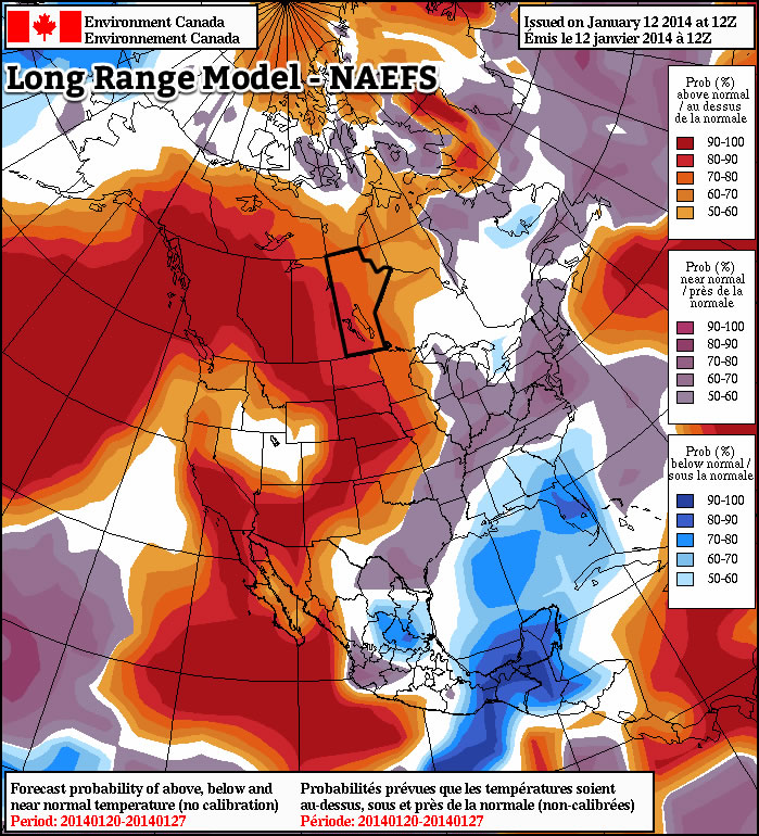
Warmer than normal weather is being forecast by the NAEFS model for the second half of January

Thursday looks to be our coldest day for the next while, with high temperatures near -20C and gusty winds making it feel much cooler. However, besides Thursday It appears we will continue to see temperatures near or slightly above normal for the next while. Long range models continue to suggest that the second half of January will be warmer than normal, though we will still likely see the odd cold day here or there. No major weather systems are in the forecast, but this pattern will probably continue to send a parade of clipper systems coming out of Alberta, bringing the chance for light snow every few days.

Tornado Threat To Develop Over Southern Manitoba on Saturday

3km EHI Values

3km EHI Values. This measures the potential strength of a tornado should one develop. As can be seen, the GFS EHI values have gone off the chart over extreme SW Manitoba on Saturday afternoon.

A slow-moving low pressure system pushing into our region will set the stage this weekend for the potential of supercell thunderstorms capable of producing localized flooding, extremely large hail, damaging wind gusts and tornadoes. Read past the break to get all the details, our thoughts on the main threat areas, and to see updated information in the comments.

Jump to Live Twitter Feed

An extremely slow-moving long-wave trough has been slowly pushing it’s way eastwards this week. While it’s been a good distance from us, we’ve been able to enjoy the benefits of such a setup: plenty of nice, warm weather with comfortable humidity. Our friends in the Western Prairies haven’t had it quite as nicely; multiple rounds of storms have pushed into Southern Alberta & Southwestern Saskatchewan over the past couple days, bringing multiple tornadoes to Southern AB and torrential rain that caused localized flooding after 2-3” fell in a short period of time. Large hail was also reported in many storms across the Western Prairies, as well as with some severe thunderstorms that developed over SE Saskatchewan on Wednesday evening.

Entrance of this system in our region has been marked by the thunderstorms and showers that developed overnight. We should see most of these clear from the Red River Valley this morning or by early afternoon if they’re really tenacious. We’ll see a relatively pleasant afternoon, with some lingering cloud and temperatures in the low-to-mid 20’s. The dewpoint will be quite high, making it feel a little sticky, though.

The main surface low begins to move into our area on Saturday, pushing a warm front up from North Dakota into extreme Southern Manitoba. Using the basic MIST principles of thunderstorm forecasting:

  • Moisture: Plentiful. Surface dewpoints will be sitting near 20°C across Southern Manitoba, with 850mb dewpoints pushing up towards 15-17°C. This deep layer of moisture will provide plenty of energy for storms to work with.
  • Instability: The major inhibition to storms will be a layer of warm air at 700mb. Temperatures will climb to 10-13°C at 700mb on Saturday morning, however cooler air will push in later in the afternoon, helping destabilize the mid-levels. LI values of -8 to -11, combined with CAPE values anywhere from 2500 J/kg to 5500 J/kg are evidence of an extremely unstable atmosphere.
  • Shear: With a decent upper-level jet pushing in through the day, most areas across southwest and south-central Manitoba will see bulk shear values increase to 30-40kt by evening.
  • Trigger: A warm front draped across Southern Manitoba will be strong enough to initiate convection in the mid-to-late afternoon as the cap begins to erode.

Prog Tephi for SW MB

Prognosis tephigram for Southwestern Manitoba on Saturday afternoon. Note the extremely favorable veering wind profile present.

Models strongly disagree about the speed of this system, but agree that it has a very strong potential to produce damaging supercell thunderstorms capable of producing tornadoes. The greatest uncertainty, then, is where exactly the storms may form. Unfortunately, as I write this it’s still too early to tell exactly where the greatest threat lies. The slowest solutions would place the main risk over extreme SE Saskatchewan across SW Manitoba, while the quicker solutions would place the risk over SW Manitoba into the Red River Valley. Personally, I feel that the slower solutions are probably a little more true to what’s going to happen. With that in mind, here’s my threat area for Saturday:

Day 2 Storm Outlook

Day 2 Thunderstorm Outlook, valid Saturday afternoon through Sunday morning. This is subject to refinement as this system develops and more certainty exists on it’s track and speed.

A large MCS will likely develop as the whole system lifts northwards overnight, which will continue to provide a severe weather threat in the form of strong winds and large hail. It will push through the RRV by Sunday morning. We may see the threat for another round of thunderstorms on Sunday afternoon, however they are not expected to be severe. Things will finally cool off on Monday as the main upper low moves through and draws in cooler, dryer air from the west.

We’ll be sure to refine the forecast in the comments below as the day approaches. In addition, it looks like the AWM crew will be out chasing, so we’ll be sure to have some live updates should everything work out. Stay sky aware out there this weekend!


new TWTR.Widget({
version: 2,
type: ‘list’,
rpp: 30,
interval: 30000,
title: ‘June 9, 2012’,
subject: ‘AWM Storm Chase’,
width: ‘auto’,
height: 500,
theme: {
shell: {
background: ‘#3c3c3c’,
color: ‘#eeeeee’
},
tweets: {
background: ‘#eeeeee’,
color: ‘#2c2c2c’,
links: ‘#489ce1’
}
},
features: {
scrollbar: true,
loop: false,
live: true,
behavior: ‘all’
}
}).render().setList(‘buffaloseven’, ‘awm-team’).start();