Warmer for Awhile

We’ll continue to see warm weather persist this week, but our snow won’t be disappearing any time soon.
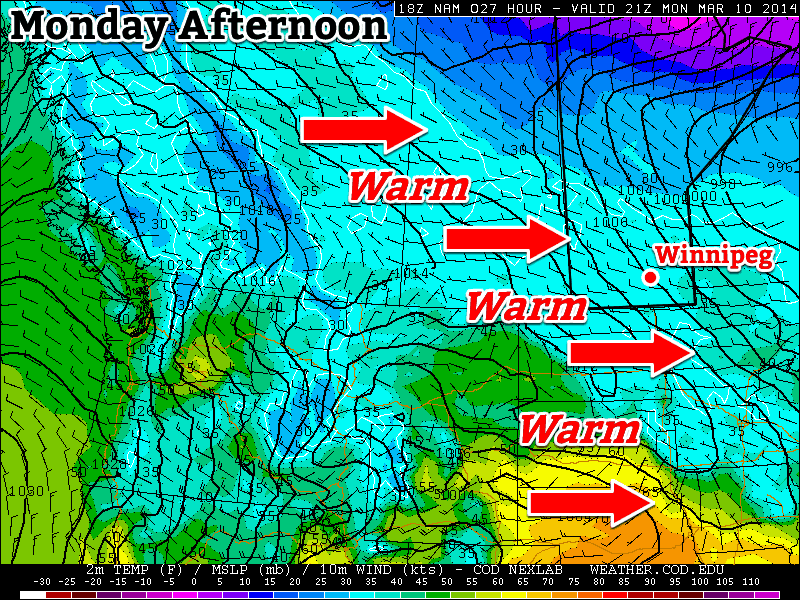
Warm air will move across the Prairies on Monday

Monday

Monday
3°C / -10°C
Mix of Sun and Cloud

Today will be one of the warmest days this week. High temperatures will edge above zero as a brisk westerly wind allows Pacific air to pour into Manitoba. Naturally, there will be some melting today, but it will do little to dent the massive snowpack in the region.

Tuesday

Tuesday
-7°C / -17°C
Mainly Cloudy. Chance of Flurries.

A high pressure system will slide down from the arctic on Tuesday, bringing a temporary return of chiller weather. It won’t be cold by any means, but it will be cool enough to halt the snow melt. There may be a few flurries around due to the presence of low cloud.

Wednesday

Wednesday
-2°C / -4°C
Mainly Cloudy

A strong southerly flow will develop in southern Manitoba on Wednesday, signaling a return to warmer conditions. Wednesday will be a fairly mild day, but those gusty south winds will make it feel quite a bit cooler than it would otherwise seem.

Long Range

The long range forecast is somewhat ambiguous at this point. Long-range weather prediction models are struggling to figure out what type of weather we’ll see for the rest of March. It appears the most likely outcome is an up and down pattern, with periods of mild weather followed by periods of colder weather. Thankfully, there is no sign of a return to the extreme cold we experienced at the beginning of the month.

Warm Weather!

This week will feature some of the warmest weather we’ve seen in a long time – it’s about time!

A warming trend will occur across southern Manitoba on Monday

A warming trend will occur across southern Manitoba on Monday

Early Week

Monday
-2°C / -10°C
Mainly Sunny
Tuesday
0°C / -14°C
Mainly Sunny
Wednesday
-1°C / -7°C
Increasing Cloudiness. Chance of Flurries Late.

Today will see temperatures climb up towards the freezing mark in southern Manitoba. That will make for messy roads, but that’s the price you have to pay for warmer weather. The wind will be light and from the west to south-east, making for a great day.

Tuesday will be very similar to Monday, with temperatures once again near zero. There will be a breezy west wind, but otherwise it will be a very nice day.

Wednesday looks to remain seasonably warm, with high temperatures once again, you guessed it, near zero. However, a low pressure system will move towards the region on Wednesday, bringing increasing clouds and a chance for flurries by late in the day. Thankfully, major snow accumulations are not currently expected with this system.

Long Range

That low pressure system from Wednesday will pull down another cold airmass for the late week period. As a result, long-range models suggest we’ll see a colder pattern lasting at least through next weekend.

Warming Up, Then Cooling Down

After a snowy, but mild weekend, we’ll see some warmer weather return – but it will be short-lived.

A southerly flow will bring slightly warmer air to Southern Manitoba on Monday

Monday

Monday

Mix of Sun and Cloud. Chance of flurries/showers
-1°C / -4°C

A southerly flow will develop through Southern Manitoba on Monday, bringing some slightly warmer weather along with it. There may be a few flurries on Monday, but no significant precipitation is expected. The wind will be relatively light and from the south.

Tuesday

Tuesday

Mainly cloudy.
3°C / 0°C

Tuesday will be warmer than Monday, as a developing low pressure system ramps up that southerly flow from Monday. Hopefully Tuesday’s warm conditions will allow some of the weekend’s snowfall to melt. The wind won’t be much stronger than on Monday, but the direction will shift to be more from the south-east.

Wednesday

Wednesday

Decreasing Cloudiness. Temperature Falling.
-6°C / -14°C

The low pressure system that brought the warmer weather to Southern Manitoba on Tuesday will move into the region on Wednesday. It appears that this system will generate an area of moderate snowfall to the north of its track, but no precipitation to the south of its track. At this point it appears the system will track in a fashion that results in no snowfall for most of Southern Manitoba, save for perhaps some parts of Western Manitoba. Regardless of whether or not this system brings us snowfall, it will bring us colder weather. A strong cold front associated with this low will bring down another arctic airmass, dropping temperatures well below zero for Wednesday and Thursday.

Long Range

The long range forecast currently looks on the cold side. Following the passage of that cold front on Wednesday models don’t hint at any immediate return to warmer conditions. Bear in mind that we are quickly moving into late November, so warm weather will being harder and harder to come by. On the bright side there is still no significant snow in the forecast, so we’re not in a true winter pattern quite yet!

Warm Start to the Week

This week will start out seasonably warm, a nice turn-around after a cool end to last week.

The Weather will be Nice in Southern Manitoba on Monday

The Week Ahead

Monday

Mainly Sunny
16°C / 6°C
Tuesday

Mix of Sun and Cloud
20°C / 6°C
Wednesday

Mainly Cloudy
16°C / 7°C

Today will be a nice day in Southern Manitoba. Temperatures will be in the mid teens under sunny skies. The wind will be light as well, making for all around pleasant conditions.

Tuesday will once again see mild conditions in Southern Manitoba. There may be a bit more cloud compared to Monday, but temperatures are still expected to be warm, with highs in the upper teens or low twenties. Tuesday will be a bit windier than Monday, but even so the wind won’t be a big issue.

Conditions will change little for Wednesday. Temperatures will once again be in the mid teens in Southern Manitoba with light winds. Wednesday will be a cloudier day however, as a weather system to our south spreads some cloud cover over Southern Manitoba.

Long Range

The weather for the late week period is looking a bit interesting. A large low pressure system is currently forecast to move through Southern Manitoba towards the weekend. At this point it appears precipitation from this system will be mostly rain, although some flurries may be possible as it exits the region. More details on this system will be available later in the week.