Above-Average Temperatures Bring Wet Weather

Daytime highs will continue to be above the seasonal average of 6°C throughout the remainder of the work week, however it will come at a cost as a series of disturbances work across the region bringing multiple rounds of wet weather.

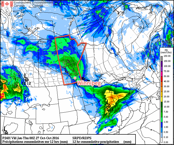
The first disturbance that will bring wet weather to Winnipeg is outside your window right now, as rain spread into the region overnight. The rain will taper off towards midday with a grand total of 5-10mm of accumulation likely for most areas.1 As the rain pushes off to the east, temperatures will climb to a high near 9°C under cloudy skies.

RDPS forecast rainfall totals for daytime hours on Wednesday.

Tonight will bring some clearing to the Red River Valley, but the lack of any significant westerly flow to the winds will prevent us from seeing widespread elimination of the cloud, meaning skies will likely remain at least mixed over the region through the night. Temperatures will drop to a low near 4°C.

Thursday will leave the region in a slack flow with mixed to mainly cloudy skies. Temperatures will climb to a daytime high near 11°C in what will be a rather unremarkable day. The next disturbance will begin moving through the region on Thursday night, thickening up the cloud cover again as temperatures drop to a low near 6°C.

Friday is a bit of a wildcard at this point…at least for Winnipeg. A low pressure system tracking along the International Border will spread an area of rain to its north, however who exactly will see rain will be a bit of a challenged as the southern edge of the accumulations will see a rapid cutoff. Complicating things is relatively minimal model agreement:

Event Total Rainfall Forecasts for Winnipeg, MB – October 28, 2016
Model Event Rainfall (mm)
RDPS N/A
GFS 0.5
NAM 1.9
GDPS 3.9
PME 4.0
GEPS 8.8

So the range in precipitation amounts goes from the GFS’ low end forecast of 0.5mm, a situation where pretty much the entire area of rain falls north of the city, up to nearly 10mm from the global ensemble prediction system. It seems likely that the bulk of the rainfall with this system will fall north of Winnipeg, with the city seeing either some brief rain or more sporadic shower activity through the day.

The temperature should reach a high near 10°C while the overnight low drops to around 5°C under cloudy skies.

Long Range

The weekend is looking dry as seasonal air returns to the region with northerly winds on Saturday and southerly winds on Sunday. The chance for rain returns to the Red River Valley on Monday.

Winnipeg’s seasonal daytime high is currently 6°C while the seasonal overnight low is -3°C.


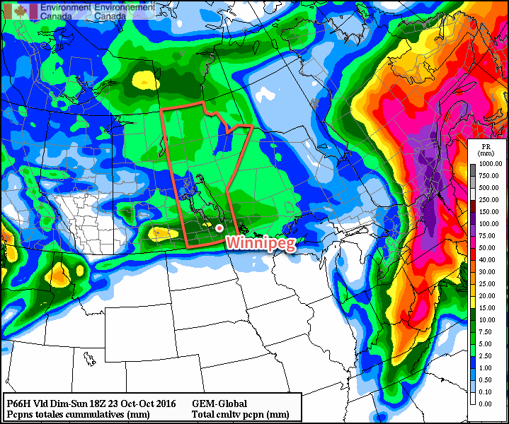
  1. A few locations along the western escarpment northwestwards into Parkland Manitoba may see total amounts in the 10-15mm range. 

Warmer & Unsettled Conditions Ahead

Winnipeg will finally break out of the 6°C lock that we’ve had on daytime highs for the past few days and see daytime highs return closer to seasonal values of 9°C. That warmer weather will, unfortunately, also come with increasingly unsettled conditions, with multiple chances for rain in the coming days. This weekend has Winnipeg host to the 2016 Tim Horton’s Heritage Classic; will the games thread the rain needle or will attendees need to bring an umbrella? Read on to find out!

Warmer temperatures will finally make an appearance in Winnipeg today as milder air is carried eastwards by a trough of low pressure pushing eastwards across the Prairies. Before we get to them, however, windy and wet conditions will move through first.

Winds will pick up out of the south to 30-40 km/h this morning, with showers developing over Western Manitoba and pushing into the Red River Valley late this morning. The showers will taper off early- to mid-afternoon with winds tapering off. Temperatures will climb up to around 10°C by late this afternoon.

Expect mainly clear skies overnight as temperatures drop down to a low near 2°C. Its possible that some fog patches or stratus cloud forms early Saturday morning.

Saturday brings the first game of the Heritage Classic, set to start at 3:00PM. Assuming skies stay clear tonight, then Saturday should bring increasing cloud through the late morning into the early afternoon. By game start, skies will be mostly cloudy with a temperature near 10°C. Rain will start pushing into the province through the afternoon, but it should remain west of the Red River Valley until around 6-7PM.

Forecast rainfall amounts from the GDPS have about 5-15mm total rainfall across Southern Manitoba shared between the Friday & Saturday night events.

Saturday night will bring periods of rain and a low near 4°C. Rainfall totals of 2-5mm seem likely by Sunday morning.

Sunday will continue with seasonal highs and clearing skies. There may be a few lingering showers early in the morning, but they should taper off quickly, leaving a fairly pleasant day with the sun breaking through in the afternoon and a high near 8 or 9°C. Winds will pick up out of the northwest to 20-30 km/h for the afternoon. While it will be a bit cooler than Saturday, overall it will be relatively pleasant conditions for the second Heritage Classic game, which starts at 2:00PM.

Sunday night should bring mainly clear skies, light winds, and a low near 0°C.

Long Range

The start of next week currently looks like it will bring seasonal temperatures and variable cloudiness. Conditions may become a little more unsettled through the latter half of the week, but at least it appears that any precipitation we may see will be rain instead of the alternative!

Winnipeg’s seasonal daytime high is currently 8°C while the seasonal overnight low is -2°C.

Cloudy & Cool Days Ahead

Winnipeg will be stuck in a fairly cloudy and cool second half to the work week as a broad upper-level trough remains entrenched over the region.

Cool & Relatively Dreary

While this morning may bring a few smiles with some sunshine, more cloud will quickly be moving back into Winnipeg, turning skies grey and leaving cool, fall-like weather in the wake. By early this afternoon, skies should be completely clouded up once again with temperatures topping out near 6°C. Winds will be out of the west-northwest at around 20-25 km/h with some gusts in the 30-40 km/h range.

Skies will remain fairly cloudy overnight with northwesterly winds continuing and temperatures dipping down to around 1°C.

Thursday morning will bring more cloudy skies with a slight chance of some shower or flurry activity as a weak band of lake-effect precipitation moves off of Lake Manitoba. It should dissipate by midday, and we’ll be left with cloudy skies that gradually begin to break up late in the afternoon, calm winds, and a high near 7°C.

Thursday night will bring a low once again near 1°C under partly cloudy skies.

Showers Possible Friday

A warm front moving across the Prairies on Friday will bring the chance of showers to the region alongside a shift to a warmer weather pattern.

A warm front will push eastwards across the Red River Valley on Friday.

By midday the chance for showers move into Winnipeg with winds picking up out of the south to 30-40 km/h. It doesn’t look like rainfall totals will be much to speak of (less than 2mm), but there may be just enough to make the ground wet.

The warmest air will remain to our south, however, so daytime highs will sit near 9°C. Friday night will bring a low near 2°C under partly cloudy skies.

Long Range

The weekend is looking slightly warmer with highs near 10°C and overnight lows continuing in the 1-2°C range. Skies will likely be mixed through the weekend and there may be another chance for some light shower activity on Saturday afternoon.

Winnipeg’s seasonal daytime high is currently 9°C while the seasonal overnight low is -2°C.

Warmer, Windier Weekend Ahead

The coming weekend brings both warmer temperatures and windier weather to Winnipeg alongside a mix of cloudy and sunny days. Fortunately, it appears that any rain or snow will hold off until the end of the weekend.

Today will mark the first wave of warmer temperatures moving into the Red River Valley as a low pressure system moving across the central Prairies brings gusty southerly winds to the region that draw warmer air northwards. Temperatures will climb to a high near 15°C today under more cloud than sun as winds pick up out of the south to 30-40 km/h with gusts on top of that. Plenty of cloud will be streaming overhead through the day; it won’t likely be completely overcast all day and the sun may poke out occasionally, but overall there will be more cloud than sun.

Warmer air will be pushing northwards across the eastern Prairies today.

Expect a low tonight near 10°C under mostly cloudy skies with winds out of the south at around km/h.

Saturday will be a beautiful day with cloud clearing in the morning, leaving a mainly sunny day behind with a high near 16°C and westerly winds of 20-30 km/h. Skies will remain clear on Saturday night with a low near 2°C.

The weather will start to turn on Sunday, but it will still be a fairly nice for a good portion of the day. Cloud will begin moving in through the morning hours as winds pick up out of the southeast to 30-40 km/h with gusts on top of that once again. Temperatures will climb to a high near 11°C before an area of rain begins moving through the Red River Valley in the mid- to late-afternoon.

Some weather models, such as the NAM pictured here, are giving Winnipeg as much as 10-15mm of rain on Sunday evening.
The rain will taper off late Sunday night as temperatures head to a low near 7°C.

Long Range

The start of next week looks fairly unsettled with more showers possible on both Monday and Tuesday. Below-normal temperatures seem likely to return mid-week.

Winnipeg’s seasonal daytime high is currently 11°C while the seasonal overnight low is 0°C.