A Reprieve From The Cold

A breakdown in the upper-level ridge over Western North America that has locked Manitoba into an unseasonably cold regime for the past 10 days will result in a significant shift in the weather for the coming weekend as warmer air finally makes its way inland from the Pacific coast. The weekend is set to end with a bang as a low pressure system taps into the warmer air and brings the first major widespread snowfall event to the Prairies.

Friday
-3°C / -5°C
Partly cloudy with a slight chance of light late-day flurries
Saturday
-1°C / -4°C
Mostly cloudy
Sunday
0°C / -13°C
Mainly cloudy; snow possible

Today will be one of those slightly unpleasant transition days into a warmer air mass being brought into the region by a low pressure system tracking across the Central Prairies. Southerly winds to 30-40km/h with gusts up to around 50km/h will make things feel a bit chilly, even though we see a warmer-than-anything-recently high near -3°C or so. If the winds manage to shift more southwesterly, then we could see several degrees added onto that high, jumping up to 0 or +1°C, however the deep layer of cold air and outflow from the ridge to our southeast will likely keep things on the cooler side.

There will be a slight chance of flurries late this afternoon into early this evening as the warm front passes by. Otherwise tonight will see mostly cloudy skies as temperatures drop to around -5°C.

Saturday looks like a fairly quiet day. Mostly cloudy skies, light winds and a high near -1°C will make for a fairly pleasant day. Temperatures will drop to around -4°C under cloudy skies and increasing east-southeasterly winds.

Sunday Brings Major Snowfall to Portions of Southern Manitoba


An updated snowfall forecast and look at this weekend’s snow is available in the comments below.


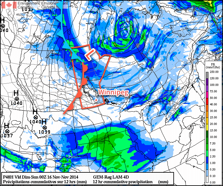
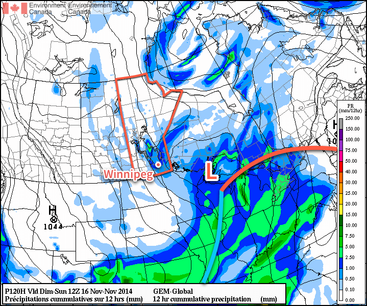
A low pressure system tracking along the International border is set to bring a substantial snowfall to portions of the Parkland & Interlake regions as a weak inverted trough persists through the region for much of the day. Snow is expected to push into Western Manitoba late Saturday and spread eastwards into the Interlake and onwards across the lakes into eastern Manitoba by Sunday morning.

A Weather Moment snowfall forecast for November 22-23, 2014. Up to 20cm of snow is possible through portions of Southern Manitoba.

Snowfall will be fairly heavy at times, and in general amounts will likely fall into the 10-15cm amount for a large swath from Dauphin to The Pas extending eastwards. For portions of the Swan River region eastwards through the northern Interlake and into Berens River, slightly higher amounts will likely be seen with up to 20cm possible.

Further south in the Red River Valley, some light snow is likely, however there’s some considerable uncertainty in how the evolution of this system will take place which is resulting in quite a spread of results. The general consensus at the moment is that little snow will be seen with amounts generally less than 2cm on Sunday, however some guidance suggests that strong low-level instability and strong lift behind the passage of the cold front in the afternoon could result in fairly intense snow over the region.

As we get closer to the event, we’ll be able to refine this forecast a little more, particularly for the Red River Valley.

Other than the snow, Sunday will be fairly mild with a high near 0°C in Winnipeg while winds starting off relatively light out of the east-southeast backing to northwesterly at a gusty 30-40km/h with some blowing snow in rural areas by Sunday evening. Much cooler air will push in through Sunday night which should allow the overnight low to drop into the minus teens.

Next week looks to start off a little unsettled with some flurries hanging on in Southern Manitoba while another shot of Arctic air begins working into the region.

Another Blustery Day Leads Towards a Pattern Change

Today will be yet another blustery day in the Red River Valley as strong northwesterly winds sit over the region behind a low pressure system that passed through overnight. Blowing snow will be an issue in some rural areas, however little new snow and a couple days of compaction since Sunday’s snowfall should result in less blowing snow than was seen then. After one last shot of cold air settling over Southern Manitoba tonight, the large-scale pattern looks set to change and allow slightly milder air back into the region.

Wednesday
-9°C / -19°C
Mixed skies with a chance of flurries; windy with local blowing snow
Thursday
-10°C / -16°C
Mainly sunny
Friday
-5°C / -9°C
Mostly cloudy and breezy

Today’s most significant weather will be the strong northwesterly winds in place through the whole Red River Valley. Gusting as high as 60-70km/h, the strong winds will make the high of -9 or -8°C feel much colder with wind chill values in the -15 to -20 range. Blowing snow will be a bit of an issue in rural areas, however with little new snow and some time for Sunday’s snow to settle, reduced visibilities in blowing snow should be much less an issue today than it was for the end of the weekend. No significant accumulations are expected today in the Red River Valley, however there may be an isolated band of higher amounts in the lee of Lake Winnipeg.[1]

Tonight will see skies clear and winds taper off as temperatures dip down to a “chilliest-this-season” low near -19 or -20°C.

After a chilly start, Thursday will be another cool day. Fortunately, light winds will make things feel not nearly as bad as Wednesday as temperatures climb towards a high near -10°C. Skies will remain mainly clear[2] on Thursday night as temperatures dip down to around -16°C.

Big Warm-Up in Store for End of Week

After a considerable amount of time with below-normal temperatures, things look set to switch around dramatically on Friday as the upper-level ridge that’s been in place for much of November over British Columbia completely collapses and a zonal flow brings milder temperatures eastwards across the Prairies.

The 850mb temperature & wind forecast for Thursday evening show a clear warm front pushing eastwards across the Prairies.

The milder air will bring a fair amount of cloud cover with it as it spreads eastwards, resulting in a mostly cloudy day in Winnipeg as temperatures climb to a relatively balmy -5°C or so. Unfortunately, with all the mild air attempting to move in, strong southerly winds to around 40-50km/h will likely develop, keeping things feeling cooler than it would otherwise. There may be a slight chance of some light flurry activity in the Red River Valley along the warm front in the afternoon, but at this point it looks insignificant.

Mild air will continue to push eastwards on Friday night, and the Red River Valley should find itself into the warm sector of this low pressure system. As a result, overnight lows will be considerably warmer than we’ve seen lately. Expect temperatures to drop to around -8 to -10°C on Friday night under partly cloudy skies.

Mild Weekend Ahead

We should see more pleasant weather on Saturday with a fair amount of sunshine and lighter winds as the temperature climbs to around -4°C.[3] Sunday continues the mild trend, however the milder temperatures will be sustained by a low pressure system tracking along the U.S. border.

The GDPS 12hr. precipitation accumulation for Sunday morning to evening shows a large swath of snowfall through Western Manitoba & the Interlake, just brushing the northern Red River Valley.

This system looks like it has the potential to bring a swath of 10+cm of snow to the Interlake westwards towards the terrain west of lakes Winnipegosis and Manitoba. Given how far out this system is, there’s a lot of details up in the air[4] and slight variations in track or intensity could dramatically shift/impact the snow event. We’ll be keeping an eye on it, but for now just keep it in the back of your head that the weekend could be ending with what could be the heaviest large-scale snow event so far this season.


  1. Very little is expected in the way of lake-induced flurry activity to the lee of lake Manitoba now that it’s mainly ice covered.  ↩
  2. Much of the night should be mainly clear, however some cloud may sneak in late in the overnight period associated with Friday’s system.  ↩
  3. The potential for highs closer to -2 or -1°C exists, but I’d rather wait until closer before getting anybody’s hopes up.  ↩
  4. Rimshot  ↩

Cool and Quiet Weather Ahead

Fairly quiet weather is on tap for Winnipeg as the Arctic air mass that has been entrenched over the region is reinforced by numerous weak systems drifting southwards in the northerly flow over the province. As a result, temperatures will remain well below normal through the weekend with some flurry activity possible.

Friday
-7°C / -15°C
Mainly sunny
Saturday
-8°C / -15°C
Mixed skies with a chance of light flurries
Sunday
-6°C / -12°C
Mainly cloudy with a few flurries

Today will be the nicest day of the next few with sunny skies as we head towards a high of around -7°C. Winds will be relatively light out of the west at 15-25km/h. Tonight will see a low near -15°C.

Saturday will bring mixed skies once again with a high near 8°C as winds shift back to northwesterly behind a weak trough moving through and lake-effect flurries start up again. No accumulations are expected, but you may see a few flakes in the air throughout the day on Saturday. Heading into Saturday night, a low pressure system that is making an extrodinary trip from essentially the North Pole straight to Southern Manitoba will begin working into the region. Cloud and a few flurries will spread into the region ahead of it through Saturday night.

The incredibly amplified flow over North America will bring a low pressure system from the high arctic straight south through Manitoba this weekend.

Sunday will be a mainly cloudy day with some light flurries through the Red River Valley. Northwesterly winds will result in some slightly heavier snow in the lee of the Manitoba lakes, however no significant accumulations are expected. The ability for the lakes to produce heavy snowfall is rapidly diminishing as ice cover continues to grow and expand, covering up the open water.

With all the cloud around and northwesterly winds in place, temperatures should climb a couple degrees warmer than Friday or Saturday to around -6 or -5°C. Heading into Sunday night, the clouds will likely break up a little bit, although the chance for flurries will continue. The low should drop to around -12°C, however it may end up a couple degrees warmer or cooler depending exactly on how much clearing takes place.

Quiet Pattern Continues

Looking ahead to next week, temperatures look to remain fairly steady with little expected for snowfall. Long-range outlooks show a move out from below-normal temperatures, but that’s more a result of the normal highs gradually falling. No major snowfalls are in the foreseeable future.

Flurries Taper Off, Cool Weather Continues

A reinforcing shot of Arctic air is pushing into Southern Manitoba for the remainder of the week. The cooler weather will gradually settle things and bring more sunshine than we’ve seen in the past while to the region, but before that happens another day of flurries lies ahead.

Wednesday
-5°C / -9°C
Periods of snow
Thursday
-7°C / -14°C
Mixed skies; chance of light flurries
Friday
-9°C / -15°C
Mainly sunny

Today will bring mainly cloudy skies with flurries continuing to drift southwards from the Interlake as general instability coupled with optimal temperature profiles[1] results in periods of snow throughout the day today. Snow will begin tapering off in the late afternoon or evening as clouds begin to break up and the northerly winds around 30-40km/h shift more northwesterly and gradually weaken.

Temperatures will climb to a high around -5°C and drop to -9 or -10°C tonight.

The forecast sounding for noon today in Winnipeg shows the deep layer of favourable snow-making temperatures – shown in white – that will be in place Wednesday and Thursday.
The forecast sounding for noon today in Winnipeg shows the deep layer of favourable snow-making temperatures – shown in white – that will be in place Wednesday and Thursday.

Thursday will bring mixed skies as clouds gradually clear throughout the day. The same temperature profile will be in place as today, so any low-level clouds will likely be able to produce some light flurry activity, but nothing significant is expected. Winds will shift to westerly at around 15-25km/h for much of the day as a ridge of high pressure slumps into the Dakotas from Saskatchewan. Expect a low near -14 or -15°C under clear skies on Thursday night.

Friday will be a beautifully sunny day, but it comes with the cost of being the coldest day so far. With relatively light west to southwesterly winds flowing out of the high pressure system to our south and southwest, temperatures will climb only to around -9°C. Temperatures will drop back into the mid-minus teens on Friday night under clear skies.

Cold Weather, Flurries for the Weekend

This weekend looks to bring flurries back to Southern Manitoba as another cold front pushes through on Saturday night. Snow will likely be found along the front as well as behind it through the day on Sunday as another unstable northwesterly flow develops.

The GDPS is showing another round of flurries pushing through the Red River Valley on Saturday night into Sunday morning.

Cold weather is expected to continue behind the front as another shot of Arctic air moves into the province.


  1. Snow grows best in temperatures between around -8°C to -15°C between the surface and around 700mb. The thermal profile over Winnipeg matches those temperatures nearly exactly which will make it very easy for snow to develop.  ↩