Weather Forecasts, Facts and News for Winnipeg & Southern Manitoba
Author: Brad
Brad lives in Winnipeg with his wife and two children and is the founder of A Weather Moment. He has loved weather from a very young age and has followed that passion through his life so far. He received a B.Sc. in Earth Sciences with Specialization in Atmospheric Sciences and is currently employed in the field of meteorology. You can find the author as WeatherInThePeg on Mastodon.
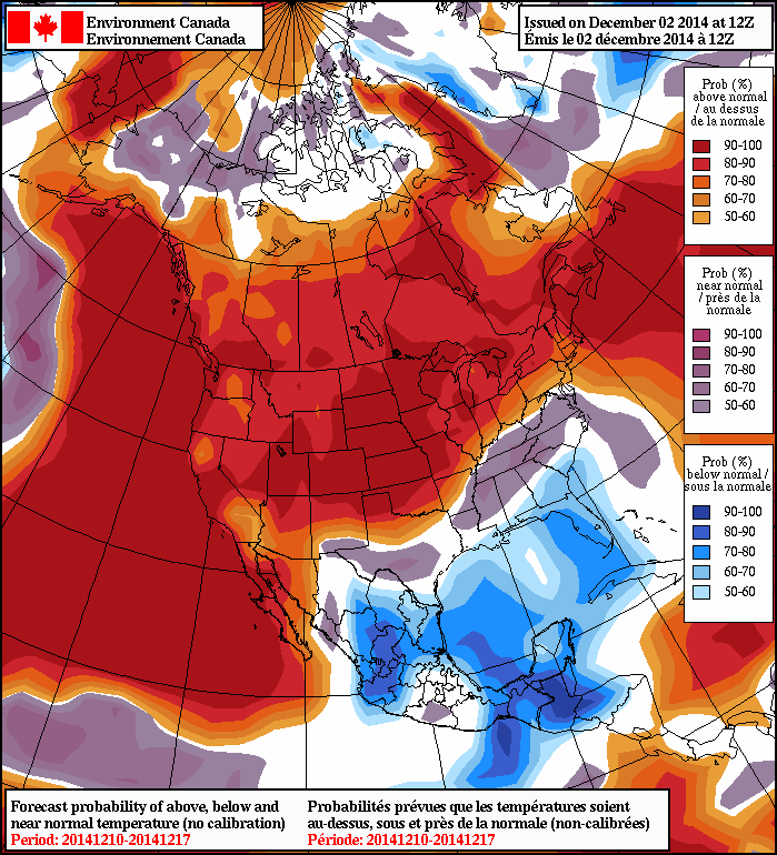
There’s no question about it: the biggest upcoming weather story is the big warm-up that’s in store not just for Winnipeg & the Red River Valley, but much of North America. After one more cold night tonight, temperatures will move towards seasonal values by the end of the week and then push towards above-normal by the end of the weekend. Given that November just finished up as the 22nd coldest on record that was some 4°C below normal[1], news of a prolonged warmer trend is likely very welcome news for many.
Wednesday
-15°C / -20°C
Mainly sunny; becoming partly cloudy in the evening
Thursday
-8°C / -15°C
Mix of sun and cloud
Friday
-9°C / -15°C
Mix of sun and cloud
Medium-range model consensus is showing high agreement in an above-normal temperature trend through the first half of December.
Today will be a relatively cool day courtesy a cold front that passed through Southern Manitoba overnight. Daytime highs will sit near -15°C through the Red River Valley today under mainly sunny skies and relatively light west to northwesterly winds. A ridge of high pressure moving through the region tonight will help temperatures dip to a chilly -20°C overnight.
Southerly winds will develop through the Red River Valley in advance of an approaching warm front quickly advancing across the Prairies. The winds – climbing to only around 20-30km/h – will help our overnight low as relatively “mild” as it is as well as begin ushering in warmer air. Temperatures will climb to around -8°C by Thursday afternoon as the winds gradually diminish under mixed skies. Temperatures will dip to the -15°C on Thursday night.
Looking to the end of the week, Friday appears to be a near-copy of Thursday with light winds, mixed skies and a high of -9 or -8°C and a low once again near -15°C.
Seasonal to slightly above seasonal temperatures will continue through the weekend alongside a slight chance for some light snow.
We’ll have our own climate summary on the fall of 2014 up later this month. ↩
A winter storm that is bringing all manner of treacherous weather to Alberta[1] will extend into Manitoba today and tomorrow in what could only be considered “a complicated setup.” Snow will arrive in multiple batches as weak upper-level impulses slide west-to-east across the province along a very strong mid-level warm front before the main low pressure system works its way into North Dakota spreading a final area of snow across Southern Manitoba alongside gusty northerly winds and colder temperatures. The whole system will push off into Ontario for Sunday leaving clear skies and cold weather to round out our weekend.
Friday
-11°C / ⇒ -11°C
Mainly cloudy with a chance of flurries; snow overnight
Saturday
⇓ -17°C / -22°C
Snow tapering off to a chance of flurries
Sunday
-19°C / -28°C
Clearing and cold
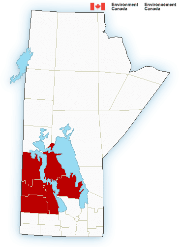
Environment Canada has issued snowfall warnings for the Parkland & Interlake regions.
While snow falls over Western Manitoba today, it will be a bit of a different story here in Winnipeg & the Red River Valley as some scattered morning flurry activity gives way to a fairly cloudy day with just a slight chance of some more scattered flurries. By late in the afternoon, however, more organized snow will begin building into the Red River Valley from the northwest, spreading southeastwards through the night.
This particular shot of snow will be courtesy of a very strong warm front in the mid-levels of the atmosphere that has been producing exceptionally snowy conditions in Alberta & Saskatchewan. Snow will continue through much of the night (a few breaks in the snow are possible) and into Saturday morning.
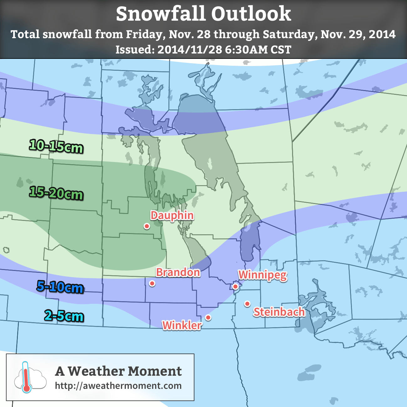
On Saturday, a strong cold front will push through the Red River Valley midday. This will lead to another distinct shot of snow associated with the cold front and the mixing zone behind it.[2] By the time all is said and done, around 5-10cm will likely have fallen here in Winnipeg and through much of the Red River Valley. If things really go off the rails, little could be seen as the first band of snow remains further north and the second band of snow passes to our south, but I don’t think that outcome is likely.
The “most probable” snowfall totals from the morning of Friday November 28th to the evening of Saturday November 29th, 2014.
The snowfall winners will be through Parkland Manitoba and the Interlake, where general amounts of 15-20cm are expected. Due to the terrain in the Parkland, up to a foot of snow could potentially fall in any areas prone to upslope enhancement.[3] The snow will taper off from northwest to southeast through Saturday afternoon.
Daytime highs today will range from around -10°C near the international border to -11°C here in Winnipeg to the mid-minus teens in the northern Interlake westwards into the Swan River region. Temperatures will remain fairly steady tonight through the Red River Valley, perhaps dropping a degree or two. Tomorrow will bring falling temperatures throughout the province as that cold front sweeps through; by the end of the afternoon temperatures will likely have dropped to around -17°C or so and then continue on an overnight low dropping into the -20 in range.
Sunday will bring clear and cold conditions to Winnipeg & Southern Manitoba. Highs will climb just above -20°C before dropping back down into the low -20s on Sunday night.
At one point yesterday, Environment Canada had issued winter storm warnings, heavy snowfall warnings, freezing drizzle advisories, and snow squall watches simultaneously for various parts of Alberta. ↩
It’s not uncommon to have what’s known as a “mixing zone” behind strong cold fronts in the winter time; the intense temperature contrast between the Arctic air and the air its replacing can result in as much as several hundred kilometers of low cloud and light-to-moderate snow in the wake of the front. ↩
…which essentially means anyone near the Riding Mountains or the escarpment. ↩
The coldest temperatures so far this season will be settling in for a short stay in Southern Manitoba before a powerful series of clippers move across the Prairies at the end of the week, bringing what may become one of the most potent winter storms seen so far this winter.
Wednesday
-18°C / -30°C
Mainly sunny
Thursday
-17°C / ⇑ -14°C
Increasing cloudiness
Friday
-10°C / -13°C
Chance of flurries
The deep freeze settles over Manitoba today as a potent high pressure system moves in from Northern Saskatchewan, bringing with it a fresh shot of Arctic air. Temperatures will warm to around -18°C from the mid-minus-twenties present this morning under mainly sunny skies. Tonight will bring the coldest temperatures of the season to Winnipeg and the Red River Valley with overnight lows dropping dangerously close – or even just below – the -30°C mark. Tonight’s record low for Winnipeg is -36.1°C set in 1891, so some solace can be had knowing it’s been colder.[1]
Tomorrow will see the cold air exit the region as a major system making landfall in British Columbia begins pushing warmer air eastwards across the Prairies. Temperatures will be on their way up, up, up with a daytime high near -17°C followed by a rising temperature trend overnight that brings temperatures up to around -14°C by Friday morning. While Thursday will start off clear, cloud will start spreading into the Red River Valley sometime midday or into the afternoon, with things becoming completely cloudy sometime in the evening.
Some light snow is possible on Thursday night along a mid-level trough in the region. While more consistent snow is likely over southwestern portions of the province, here in the Red River Valley little is expected in the way of accumulations. We’ll keep an eye on it, but it looks like amounts will remain less than 2cm in any activity that develops.
Friday Brings Winter Storm to Portions of Manitoba
Friday will likely be a bit of a mess of a day…somewhere. A potent low pressure system will track eastwards near the international border, spreading an area of snow ahead of it and another area of snow to its north. It’s really too early to make too many accurate predictions other than a whole host of weather being possible on Saturday. Some areas of the Red River Valley will likely see some snow while a more organized snow event occurs (once again) through Parkland Manitoba eastwards through the Interlake and into the Berens River Region. There’s simply too much uncertainty with the track and strength of the low at the moment to create a snowfall forecast; it looks like a possible snowfall warning event will occur through the Interlake[2] while lesser amounts track along and south of the Trans-Canada corridor. We’ll be making a snowfall forecast graphic a little closer to the event when we can have more confidence in the amounts.
Just one of many model solutions, the GDPS shows lighter precipitation amounts (just 2-5cm of snow, generally) in Southern Manitoba from Friday morning to Saturday morning.
On Friday evening, temperatures will continue to rise with southerly winds into the mid-minus single digits, but then the low will pass and the winds shift around to northwesterly at 30-40km/h. Ample low-level moisture coupled with an incoming – and very dry – 50kt jet at 700mb may result in some freezing drizzle or snow grains overnight. The northwesterly winds will bring in substantially colder air with temperatures dropping to around -12 or -13°C after the evening rising trend.
Colder Air Returns for the Weekend
Saturday will bring clearing skies as another ridge of high pressure moves into the province. Temperatures will only recover slightly from Friday’s overnight low thanks to a fairly breezy northwesterly wind before dropping into the mid-minus 20’s on Saturday night under clear skies. Sunday looks sunny with a high in the low minus teens and calmer winds.
A breakdown in the upper-level ridge over Western North America that has locked Manitoba into an unseasonably cold regime for the past 10 days will result in a significant shift in the weather for the coming weekend as warmer air finally makes its way inland from the Pacific coast. The weekend is set to end with a bang as a low pressure system taps into the warmer air and brings the first major widespread snowfall event to the Prairies.
Friday
-3°C / -5°C
Partly cloudy with a slight chance of light late-day flurries
Saturday
-1°C / -4°C
Mostly cloudy
Sunday
0°C / -13°C
Mainly cloudy; snow possible
Today will be one of those slightly unpleasant transition days into a warmer air mass being brought into the region by a low pressure system tracking across the Central Prairies. Southerly winds to 30-40km/h with gusts up to around 50km/h will make things feel a bit chilly, even though we see a warmer-than-anything-recently high near -3°C or so. If the winds manage to shift more southwesterly, then we could see several degrees added onto that high, jumping up to 0 or +1°C, however the deep layer of cold air and outflow from the ridge to our southeast will likely keep things on the cooler side.
There will be a slight chance of flurries late this afternoon into early this evening as the warm front passes by. Otherwise tonight will see mostly cloudy skies as temperatures drop to around -5°C.
Saturday looks like a fairly quiet day. Mostly cloudy skies, light winds and a high near -1°C will make for a fairly pleasant day. Temperatures will drop to around -4°C under cloudy skies and increasing east-southeasterly winds.
Sunday Brings Major Snowfall to Portions of Southern Manitoba
A low pressure system tracking along the International border is set to bring a substantial snowfall to portions of the Parkland & Interlake regions as a weak inverted trough persists through the region for much of the day. Snow is expected to push into Western Manitoba late Saturday and spread eastwards into the Interlake and onwards across the lakes into eastern Manitoba by Sunday morning.
A Weather Moment snowfall forecast for November 22-23, 2014. Up to 20cm of snow is possible through portions of Southern Manitoba.
Snowfall will be fairly heavy at times, and in general amounts will likely fall into the 10-15cm amount for a large swath from Dauphin to The Pas extending eastwards. For portions of the Swan River region eastwards through the northern Interlake and into Berens River, slightly higher amounts will likely be seen with up to 20cm possible.
Further south in the Red River Valley, some light snow is likely, however there’s some considerable uncertainty in how the evolution of this system will take place which is resulting in quite a spread of results. The general consensus at the moment is that little snow will be seen with amounts generally less than 2cm on Sunday, however some guidance suggests that strong low-level instability and strong lift behind the passage of the cold front in the afternoon could result in fairly intense snow over the region.
As we get closer to the event, we’ll be able to refine this forecast a little more, particularly for the Red River Valley.
Other than the snow, Sunday will be fairly mild with a high near 0°C in Winnipeg while winds starting off relatively light out of the east-southeast backing to northwesterly at a gusty 30-40km/h with some blowing snow in rural areas by Sunday evening. Much cooler air will push in through Sunday night which should allow the overnight low to drop into the minus teens.
Next week looks to start off a little unsettled with some flurries hanging on in Southern Manitoba while another shot of Arctic air begins working into the region.