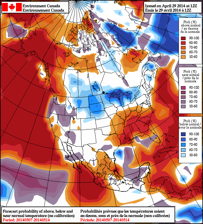
A Blast of Winter to Start the Week

We’ll get an early taste of winter today as an arctic high settles in over Manitoba.

It Will be a Cold Start to the Week with a Large Arctic High Over the Region

It Will be a Cold Start to the Week with a Large Arctic High Over the Region

Monday

Monday

Mainly Sunny
-10°C / -15°C

Today will be a cold day by early November standards. Temperatures will remain well below zero for the duration of the day thanks to an arctic high over the region. Thankfully the wind won’t be very strong, which is some slight consolation for what will otherwise be a rather algid day.

Tuesday

Tuesday

Mainly Sunny
-2°C / -6°C

Temperatures will begin to recover on Tuesday as a surge of warmer air begins pushing in from the west. Temperatures on Tuesday will be around or just below zero in Southern Manitoba, with a breezy wind out of the south-west.

Wednesday

Wednesday

Increasing Cloudiness
4°C / -2°C

Wednesday looks to be one of the warmer days this week, with temperatures in the mid positive single digits. The wind will be from the west or south-west and skies will be on the cloudy side.

Long Range

The late week period looks to remain on the warm side, with daytime temperatures staying above zero. Weather models suggest that another push of arctic air may be on the way for next weekend, though we can always hope that the models are wrong. At least we can say that no significant snow is currently in the forecast – but as today’s weather has shown us, winter is certainly not far off.

Snow On The Way

A low pressure system pushing eastwards across the Southern Prairies and the Northern Plains will spread snow and rain into Southern Manitoba today.  Amounts are not expected to be significant in the Red River Valley – especially in areas near the international border – but it will be one of the first “snowy” days of the year.


Total forecast precipitation (liquid-eqivalent) from Friday morning to Saturday morning.

Today

Friday

2°C / -2°C
Cloudy with light snow beginning this afternoon.

Precipitation will begin pushing into the southern Red River Valley later this morning and into the northern half of the valley, including Winnipeg, this afternoon as the low pressure system begins working it’s way into the region.  Precipitation will fall mainly as snow through the northern half of the Red River Valley while in the southern half of the valley some light rain will be more likely. Naturally there will be a transition zone somewhere in the central RRV where amounts will not be too significant with only a cm or two falling here in Winnipeg at most.  Further south, up to a 3–4mm of rain could fall.  Light snow will taper off in the evening leaving behind a chance of some flurry activity through the overnight hours.  We’ll see a low dipping just below 0°C.

The Weekend

Saturday

2°C / -6°C
Mainly cloudy; chance of flurries.

Saturday will be a mainly cloudy day with a slight chance of flurries throughout as cool, somewhat unstable air continues to push south behind the low.  No significant accumulations are expected and we’ll climb to a high of around 2°C.  The winds will be a somewhat gusty 30km/h out of the northwest through the day.  Through the overnight things will be mainly cloudy, although a few breaks in the cloud are expected, as we dip to a low of about –6°C.

Sunday

-2°C / -13°C
Mixed skies; slight chance of isolated morning flurries.

On Sunday skies will improve while temperatures do not.  We’ll see a mixed sky with a high of only –1 or –2°C.  A few light flurries may be possible in Winnipeg in the morning as we may be just grazed by a weak system passing through the Interlake.  Cooler air will continue to filter southwards through the day and drop us to a very chilly –12 or –13°C on Sunday night under mainly clear skies.

After that, a fairly sunny, cool and quiet week is ahead next week as a large arctic ridge dominates the weather over the Eastern Prairies.

Cool & Quiet; Light Snow To End the Week?

We’ll stay the course with cool, benign weather through the remainder of the week as weather systems stay well to our north and south.

Wednesday

1°C / -8°C
Cool; mixed skies.
Thursday

1°C / -7°C
Mainly sunny.
Friday

1°C / -5°C
Cloudy; chance of snow in the afternoon.

Today and tomorrow with both bring a high near 1°C, albeit with mixed skies today and mainly sunny skies tomorrow.  Tonight and tomorrow will both drop down into the low minus single digits.

Friday will bring the next chance for snow to our area as a low pressure system pushes across the Southern Prairies.  Skies will cloud up early in the morning and temperatures will climb to 1 or 2°C.  By the afternoon, the chance for some light snow will push into Winnipeg and the Red River Valley.  The chance for light snow looks to last through Friday night and into Saturday morning, perhaps even into Saturday afternoon.  The snow potential for Friday and Friday night looks the best with the chance for some stronger bands, while on Saturday it seems like there’s just a slight risk for some light flurry activity.  That being said, it still only looks like perhaps a cm or two at most would fall over the region, if any at all.

The main uncertainty with the snow for Friday centres around the fact that as the system approaches Southern Manitoba, a second low is forecast to develop through the Dakotas which will consolidate the heavier snow down towards it. At this point, it looks like the heaviest snowfall (perhaps as much as 1-1.5 inches) will fall through North Dakota. If the Dakota low ends up tracking a little further north, it’s possible that we’ll see some accumulating snowfall in areas close to the US border. We’ll keep an eye on this system and have an in depth look in Friday’s post.

After that things look like we’ll be settling back into a benign pattern with little activity expected until mid-week and cool temperatures with highs near 0°C.

Cool and Calm

The weather this week will be cool and calm, meaning no big weather makers are in the forecast.

Early Week

Monday

Mix of Sun and Cloud. Slight Chance of Flurries.
4°C / -1°C
Tuesday

Mainly Cloudy
2°C / -8°C
Wednesday

Mainly Sunny
0°C / -8°C

Monday will be a seasonably warm day in Southern Manitoba. A cold front will pass through in the morning, causing the wind to shift to westerly. Temperatures will be in the low to mid single digits.

Tuesday should see seasonable conditions continue in Southern Manitoba. Temperatures will be in the low single digits with a light westerly wind.

Wednesday will be very similar to Tuesday, with temperatures once again in the low single digits and winds being light.

Long Range

The long-range forecast looks to feature mostly seasonal weather. However, we’ll likely see our first snowfall of this fall at some point in the next 5-10 days. It probably won’t be a significant snowfall, but a snowfall nonetheless.