Temperature Roller Coaster On The Way to A Prolonged Mild Spell

After a bit of a chilly start to February, this week will bring a transition into a prolonged period of significantly above-normal temperatures. Before we get there, though, Winnipeg will be going through a bit of a temperature roller coaster through the first half of the week.

More warm weather is on the way today thanks to a westerly flow that will bring partly cloudy skies and high temperatures just above the freezing mark across Winnipeg & much of the Red River Valley. Winds will be a bit breezy out of the southwest to west at 20-30 km/h.

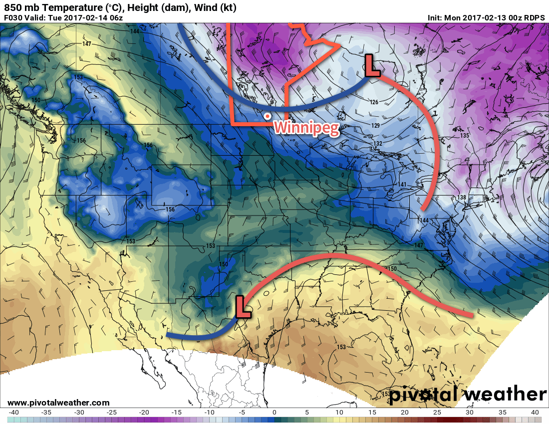
Temperatures will continue to be mild tonight with partly cloudy to mixed skies. A cold front will move through late overnight, ushering in moderate northwesterly winds to around 30-40 km/h that will drop temperatures to -4 or -5°C by Tuesday morning.

A cold front will sweep southwards through Winnipeg on Monday night.

The breezy northwesterlies will continue on Tuesday with temperatures falling to around -9°C by the end of the afternoon. Winds will taper off in the evening alongside some clearing skies. Temperatures will dip to a low near -16°C. Cloud cover will move back in overnight, moderating the temperature slide; should the cloud come in a bit earlier or later, the overnight low may be warmer or colder.

Wednesday will bring warmer weather back into the region as winds swing around to the south and skies remain mainly cloudy. Temperatures will reach a high near -4°C. Temperatures will dip to a low near -8°C under partly cloudy skies on Wednesday night.

Long Range

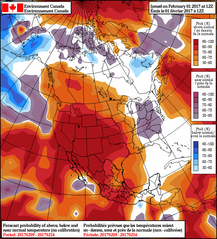
It’s in the second half of the week the warmer weather really sets up. Daytime highs will be at or above the freezing mark beginning Thursday and persisting all the way into next week. Overnight lows will also be very mild, hovering just below the freezing mark.

Winnipeg’s seasonal daytime high is currently -8°C while the seasonal overnight low is -19°C.

After A Chilly Wednesday, Temperatures Set to Skyrocket

It will be a bitterly cold morning today across southern Manitoba with wind chill values dipping as low as -42 or -43 in some locations, but this cold weather is short lived as a rapidly building upper-level ridge allows mild Pacific air to flood eastwards across the Prairies.

A bitterly cold ridge of high pressure will bring well below-seasonal temperatures to the region with daytime highs across southern Manitoba struggling to climb much above the -20°C mark. Winds will also pick up out of the west to around 20-30 km/h, maintaining wind chill values below -30 all day. No question about it, it’s going to be a cold one.

Temperatures will dip to the mid-minus 20’s tonight with relatively south to southwesterly light winds as the ridge axis moves through.

Thursday will begin the warmup as a the Arctic ridge begins moving off to the east and milder air begins pushing into southern Alberta & southwestern Saskatchewan. Here in Winnipeg, temperatures will climb to a high near -14°C with gradually increasing cloud cover. Winds will pick up out of the south in the late afternoon to around 30-40 km/h ahead of the incoming warm front. Snow will then spread into the region overnight with winds tapering off and temperatures rising to around -9°C by Friday morning.

A low pressure system will spread snow across southern Manitoba on Thursday night, however there is some uncertainty of how far north the snow will fall.

The snow will taper off on Friday morning, leaving behind mostly cloudy skies with a chance of freezing drizzle. Temperatures will continue to climb to a high near -2°C, although temperatures could climb above the freezing mark near the US border. Skies will become mixed as temperatures drop to a low near -12°C on Friday night.

Long Range

In general, the future looks pleasant. Above-normal temperatures are expected to be in place throughout all of next week with daytime highs averaging in the mid-minus single digits.

Winnipeg’s seasonal daytime high is currently -9°C while the seasonal overnight low is -20°C.

Unsettled Conditions Lead to Short Mid-Week Cold Snap

More cloud & light snow is on the way today before cooler temperatures and sunshine move into the region midweek.

More snow is on the way for Winnipeg as the final disturbance in a rather active storm track moves into the region. Before that, though, Winnipeg will see any remaining light snow taper off this morning as Sunday night’s low moves out of the region. The rest of the day will bring cloudy skies with a very slight chance of some scattered flurries and a high near -15°C.

The last disturbance of the series will be moving through this evening, bringing another shot of snow to the Red River Valley. Amounts will be highest near the US border, with another dump of 5-10 cm expected. Amounts taper off heading northwards, with around 2-4 cm expected along the Trans-Canada Highway corridor, including Winnipeg.

Temperatures will drop to a low near -19°C tonight.

Another swath of snow will spread across Southern Manitoba tonight with general new snow totals of 5-10cm.
The snow will taper off midday Tuesday, followed by clearing skies. Temperatures will reach a high near -17°C, but they’ll begin to fall as soon as the clearing sets in. Temperatures will bottom out near -25°C on Tuesday night under partly cloudy skies.

Wednesday will see things finally settle down, with partly cloudy skies and a below-normal high near -17°C, all courtesy a ridge of high pressure swinging through. Skies will remain clear on Wednesday night as temperatures dip to a low near -23°C.

Long Range

The colder weather will be short-lived, fortunately, as warmer weather returns for the weekend. Alongside a couple chances fro some light snow, it appears that Winnipeg & the Red River Valley will be heading into a prolonged period of above-normal temperatures, with daytime highs in the generally between -10 and -5°C by the weekend and persisting through next week!

Winnipeg’s seasonal daytime high is currently -10°C while the seasonal overnight low is -20°C.

A Seasonal-ish, Cloudy Weekend Ahead

Temperatures will moderate slightly for a near-seasonal weekend as a series of disturbances tracking along or just south of the U.S. border spread cloud and a chance of flurries across Southern Manitoba.

Today brings increasing cloudiness as a bit of morning cloud thickens up from the west through the afternoon ahead of the first of several systems. Temperatures will climb to a seasonal -11°C with fairly light winds. Cloudy skies tonight will keep temperatures from falling too far; the overnight low will be a reasonable (for early-February) -18°C.

A low pressure system will track through North Dakota on Saturday with an inverted trough extending northwards from the low centre sweeping across Southern Manitoba. This will result in a fairly good chance of flurries or light snow with general amounts of 2-4 cm. Light winds will swing from south to northwest through the day.

Models suggest up to 2-4*cm* of fluffy snow is likely on Saturday.

Temperatures will reach a high near -9°C on Saturday with an overnight low near -19°C.

Sunday will be a bit of a mixed day as the main cloud shield from this system exits off to the east and the cloud shield from the next system begins moving in from the west. Thanks to cooler air pushing in behind Saturday’s system, daytime highs will be cooler at around -15°C, but the winds should be light. There will be just a slight chance of some flurries through the day. Expect a low near -20°C on Sunday night with winds beginning to shift out of the northeast by Monday morning.

Long Range

It appears that Monday and Tuesday will both bring chances for more organized snowfalls, with the second system showing some potential to be something that actually produces moderate widespread accumulations.1 After those two systems, a fairly potent ridge of high pressure moves in from the Arctic, sending temperatures well below normal for the middle of the week.

The NAEFS is trending towards higher probabilities of above-normal temperatures in mid-February.

The cold snap looks to be short-lived, though. By the weekend, models suggest a significant pattern change with a more zonal flow becoming dominant and spreading milder Pacific air eastwards across the Prairies.

Winnipeg’s seasonal daytime high is currently -10°C while the seasonal overnight low is -21°C.


  1. At this point, models suggest that it could produce up to 10-15 cm of snow in portions of Southern Manitoba.