The Cold Front is Coming!

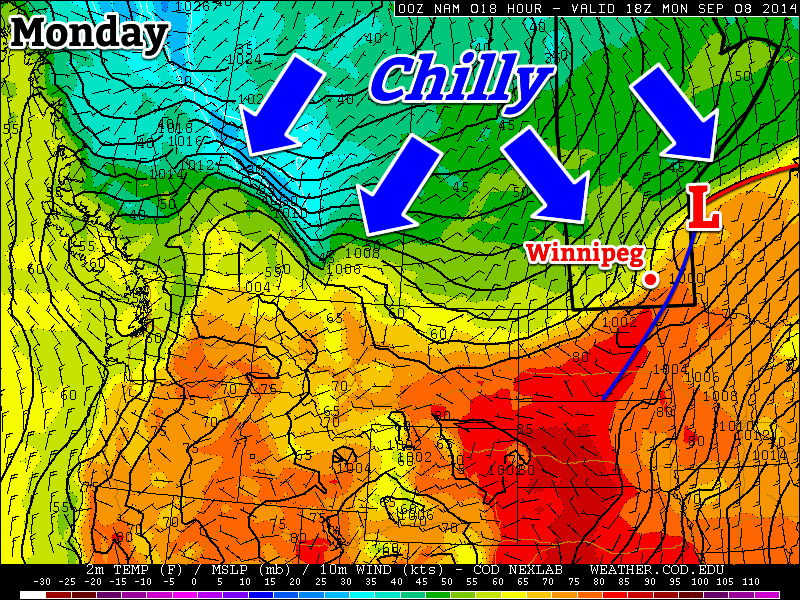
The cold front is coming! The cold front is coming! After a pleasant weekend, things will turn sharply cooler this week as a potent cold front plows through southern Manitoba today.

A cold front will bring sharply cooler weather to southern Manitoba on Monday

Monday

Monday
22°C / 7°C
Mainly cloudy with chance of showers

Today will see a strong cold front sweep through southern Manitoba. The front will move through western Manitoba early in the morning, exiting the province by late afternoon or early evening. There may be a few showers along this cold front, but no significant precipitation is expected. However, temperatures will drop significantly behind the front, and winds will increase as well, marking an end to summery weather, at least for now.

Tuesday

Tuesday
10°C / 4°C
Mainly cloudy with showers

Tuesday will be a nasty day. High temperatures will struggle to reach double-digits and there will be a breezy north wind. To add insult to injury, we may also see some showers throughout the day, just adding to that nasty fall feel. This will be our first taste of fall weather since, well, last fall!

Wednesday

Wednesday
12°C / 2°C
Mix of sun and cloud

Wednesday will be another cool day in southern Manitoba. High temperatures in the low double digits are expected, with a breezy north wind once again.

Long Range

After reading about the gloomy weather above, you’re probably hoping this isn’t it for summer…well, all hope is not lost, at least not yet! Long range models suggest that we may return to a more summery pattern at some point in the second half of September. Let’s hope the long range forecast is correct!

Pleasant Weekend Before Big Cool Down

After a dreary evening last night, conditions will gradually improve to quite a pleasant weekend for Winnipeg & the Red River Valley.

The RDPS model is forecasting a line of showers & thunderstorms through the Red River Valley by 5-7PM this evening.
The RDPS model is forecasting a line of showers & thunderstorms through the Red River Valley by 5–7PM this evening.

Today will start off with a bit of cloud through the Red River Valley thanks to the Manitoba lakes. We won’t see completely sunny skies, though, as a combination of increasing instability and some cloud moving in ahead of a trough moving across the province produce mixed skies through much of the day.

Friday
18°C / 5°C
Increasing cloud; a chance of showers or thunderstorms in the afternoon.

This afternoon into early this evening will bring a slight chance for showers or thunderstorms across the Red River Valley as that trough line works its way through the region. At this point it doesn’t look like severe weather is likely. Once the trough swings through, northerly winds at around 30km/h will move into the region and general clearing will take place.

Cooler air aloft will once again slump over Southern Manitoba tonight, bringing with it a chance for lake-effect cloud and drizzle once again. Winds, in general, don’t look particularly favourable which will likely limit or exclude their development. Winds will taper off overnight and low temperatures will be near 4 or 5°C.

Improving for the Weekend

Saturday
21°C / 8°C
Cloudy periods

Sunday
23°C / 12°C
A few clouds

Warmer weather will move in for the weekend as multiple low pressure systems draw warmer air eastwards across the Prairies as they move across Central Manitoba. Precipitation is expected to remain through Central & Northern Manitoba, leaving us dry with seasonal highs in the low 20’s. Overnight lows look to dip to around the 10°C mark, give or take a couple degrees.

Big Cool Down Next Week

Unfortunately, the pleasant weather will not be sticking around. Colder air builds into the Northern Prairies behind the systems tracking through during the weekend, which will then be driven southwards early in the week as an Alberta-clipper type system races across the Prairies.

The CPC 6-10 day temperature & precipitation anomaly outlook calls for below normal temperatures and near- to slightly above-normal precipitation.
The CPC 6–10 day temperature & precipitation anomaly outlook calls for below normal temperatures and near- to slightly above-normal precipitation.

850mb temperatures are forecast to drop into the 0°C to –5°C range by mid-week, resulting in daytime highs dropping towards the low teens and overnight lows likely dipping towards the 0°C mark. By mid-week, frost will be a definite concern across Western Manitoba and into the Red River Valley. The big question here in Winnipeg & the RRV will be exactly how much cloud the lakes produce when the cold air slides over them.

At this point it looks like a brief moderate at the end of the week before another cold blast potentially moves through.

Another Storm on the Way

Wednesday will be a brief reprieve from the showery weather before a fairly potent low pressure system spreads more rain & thunderstorm activity across Southern Manitoba tonight into tomorrow morning and brings dreary weather for Thursday with strong northwesterly winds.

Wednesday
23°C / 13°C
A few sunny breaks; rain overnight.

Thursday
19°C / 6°C
Rain and drizzle tapering off mid-day. Risk of a thunderstorm. Windy.

Friday
19°C / 5°C
Mainly sunny.

Today will be a fairly pleasant day with mostly cloudy skies and a high near 23°C or so. There’s a slight chance of an isolated shower or three through the Red River Valley, including Winnipeg, but for now it looks like the activity should mainly remain to our west over southern Saskatchewan and southwest Manitoba.

Tonight, an inverted trough extending NW from a low pressure system moving through the Dakotas will spread rain with the risk of thunderstorms eastwards into the Red River Valley. Rain will likely start sometime after 1AM and persist until mid-morning Thursday. The temperature will dip to around 13°C.

The Canadian RDPS is one of the models rather bullish on higher precipitation amounts Wednesday night.

Rainfall totals for tonight are still uncertain; the general agreement is for between 10–20mm, however if substantial elevated convection develops as much as local amounts of 40–50mm may be possible. The low end of precipitation forecasts produce only around 5mm of rain.

I feel fairly comfortable with 10–20mm of rain tonight, but we’ll reassess the elevated convection potential later today and update if necessary. We’ll try and have an update fairly early this afternoon.

Unpleasant Thursday

Thursday will be quite an unpleasant day as Winnipeg moves onto the back side of the low pressure system lifting northeastwards into Ontario. The bulk of the rain should taper off mid-day, but brisk northwesterly winds building to 30–40km/h will accompany cloudy skies and a high struggling to climb into the upper teens. It’s also fairly likely drizzle will persist after the main area of rain moves out, making for a generally dreary day.

Skies will clear out for the evening, although there may be some cloudy periods through the first half of the night with some cloud moving off of Lake Manitoba, and temperatures will drop to a chilly 5 or 6°C.

Fall-Like Friday

Friday will be fairly pleasant, albeit cool, with mainly sunny skies and a high near 19 or 20°C. Winds will be fairly light through the day.

Friday night should bring clear skies and a low near 5 or 6°C.

A Look Ahead to the Weekend

The upcoming weekend is looking fairly good with unpleasant weather staying to our north. It’s looking like plenty of sun is in store with daytime highs in the ballpark of the seasonal 21°C mark and overnight lows moderating by the end of the weekend.

Plesant End to the Long Weekend

This week will start off with pleasant conditions, as we experience a nice end to the long weekend.

Labour Day will be pleasant in southern Manitoba

Monday

Monday
23°C / 8°C
Mix of sun and cloud with a chance of showers or thunderstorms

Today will be a pleasant day in southern Manitoba. Temperatures will be in the low to mid twenties with a light westerly wind and partly sunny skies. There will be a slight chance of showers or thunderstorms, but any rain should be isolated and short-lived. Overall, it will be a good end to the last long weekend of summer.

Tuesday

Tuesday
24°C / 10°C
Mix of sun and cloud with a chance of showers or thunderstorms

Tuesday will be another nice day in southern Manitoba. Skies will be a mixture of sun and cloud, with temperatures in the mid twenties. There will once again be a slight chance of showers or thunderstorms, but they’ll again be isolated.

Wednesday

Wednesday
24°C / 13°C
Mix of sun and cloud

Wednesday will once again feature seasonably warm conditions in southern Manitoba. High temperatures will be in the low to mid twenties with light winds.

Long Range

The long range forecast is a bit uncertain at this time. It looks like we’ll generally see near seasonal conditions in the short to medium term, which means temperatures in the lowish twenties. There will however be some days warmer, and some cooler, than seasonal values.