More summery weather is in store this week, just what you were hoping for I’m sure!
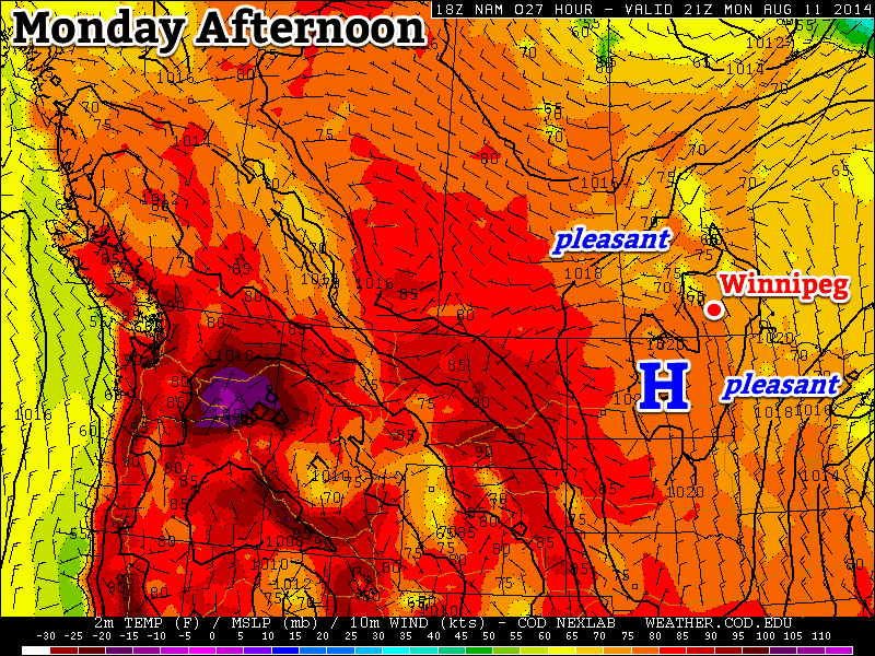
Monday will be a pleasant day in southern Manitoba
Monday
Monday
24°C / 10°C
Mainly Sunny
Today will be a pleasant and uneventful day weather-wise. Temperatures will be in the mid twenties with a light northerly wind and mainly sunny skies. You can thank the surface high pressure system over top of us for the nice day.
Tuesday
Tuesday
28°C / 16°C
Mainly Sunny
Tuesday will be another nice day in southern Manitoba. Temperatures should once again climb into the upper twenties with a light northerly wind and mainly sunny skies. There may be a few pop-up showers or thunderstorms in the afternoon and evening, but they will be highly localized. The most favoured area for one of these storms is in the Interlake.
Wednesday
Wednesday
28°C / 18°C
Mainly Sunny
Wednesday will be fairly similar to Tuesday, with temperatures in the upper twenties and mainly sunny skies. The wind will veer to easterly, but won’t be too strong. No precipitation is expected during the day on Wednesday.
Long Range
The long range forecast is looking pretty good. Some models continue to hint at a cool-down sometime in mid to late August, but there are no indications that cooler weather is imminent. In the mean time, normal to above normal weather should continue, which means high temperatures in the mid to upper twenties.
More unsettled weather is on the way as another generally unstable day gives way to the passage of a low pressure system and associated cold front that will finally result in a shift in the larger-scale weather pattern.
Friday
30°C / 18°C
Partly cloudy
Saturday
28°C / 16°C
Mainly sunny; evening thunderstorms likely
Sunday
25°C / 12°C
Mainly sunny
Generally unsettled weather will be in place over Southern Manitoba today as an unstable air mass continues to preside over the region. Shower activity will likely continue to remain elusive here in Winnipeg, but elsewhere, particularly northwards into the Interlake may see a few showers or thundershowers today. It will be hot with high temperatures near 30° combining with dewpoint values near 20°C making it feel more like the upper 30’s. Temperatures will dip just below the 20°C mark overnight under mainly clear skies.
Saturday will be another hot and humid day with plenty of sunshine. Increasing cloud in the afternoon ahead of an advancing cold front will restrain the daytime high to a couple degrees cooler than today. Winds will be the strongest they’ve been in a while, strengthening to 30-40km/h out of the south by late in the afternoon.
A line of showers and thunderstorms will develop along a cold front stretching from the northern Interlake into southwestern Manitoba late in the day and gradually push eastwards through the evening. It’s very likely that most places in the Red River Valley, Winnipeg included, will see some shower or thunderstorm activity as the front passes through. Rainfall amounts will be quite variable; it looks like 5 to 15mm will be fairly common, however higher amounts will be possible in thunderstorms. Skies will clear behind the cold front with temperatures dropping to the mid-teens.
Sunday will be a beautiful, albeit cooler, day. Southern Manitoba will see just a few clouds and a high near 24 or 25°C. Much of the humidity will be flushed out by the cold front, so it should also be a much more comfortable feeling day as well. There may be a slight chance of some isolated shower activity on Sunday night as a weak disturbance ripples southeastwards across the province. Temperatures will drop into the low teens on Sunday night.
The warm, dry weather that has dominated over the past week will continue through the remainder of this week as an area of high pressure continues to stake its claim over the Red River Valley.
Wednesday
27°C / 17°C
Mostly cloudy
Thursday
28°C / 17°C
Mixed skies with slight chance of isolated showers
Friday
27°C / 15°C
Mainly sunny
Wednesday
Today will bring a fair amount of cloud, but it appears that any precipitation will likely remain west of the Red River Valley in Southwestern Manitoba northwards into the Parkland region. There will likely be a small chance of some isolated showers through the Red River Valley, but the odds look slim and even if there were, the total rainfall amounts would be minimal.
While the dry weather is generally appreciated given the wet spring and start to summer, some rainfall would be welcome in the Red River Valley. Winnipeg’s July ended as the 14th driest on record while, in general, the southwestern Red River Valley has now fallen to between 75–90% the normal accumulated precipitation for the growing season. For crops that are near harvest, the dry weather has been welcome, but some crops will be beginning to undergo some stress due to the lack of rainfall. Unfortunately, no significant rains are in the forecast in the coming week.
Percentages of the normal seasonal accumulated precipitation show below-normal rainfall developing in the southwestern Red River Valley.
Cloud and precipitation aside, today will be pleasant. Daytime highs will sit in the upper 20s with light winds. There’s significant disagreement as to what will happen overnight, though, as some models produce no precipitation whatsoever – which is what I’m leaning towards – while others develop an area of showers in the evening and move it through the Red River Valley.
While the possibility certainly exists for some rain tomorrow night, or even an isolated thunderstorm, it’s most likely that the weather will remain dry in the Red River Valley. We’ll be sure to provide an update in the comments below as things become more clear later today. The temperature will drop into the upper teens overnight.
Thursday & Friday
Warm temperatures will continue Thursday with daytime highs once again in the upper 20s. Skies will be mixed with an outside chance of isolated showers in Winnipeg & the Red River Valley. Winds will continue to be light.
Partly cloudy skies with a slight chance for isolated shower activity returns Thursday night as temperatures dip into the upper teens.
Friday will bring partly cloudy skies with a high once again in the mid-to-upper 20’s. Friday night will bring partly cloudy skies with a low in the mid-teens.
Weekend Look-Ahead
The GDPS is forecasting some rainfall on Saturday night as a weak cold front sweeps through the region.
Summer weather continues right through the weekend with plenty of sunshine on Saturday and Sunday with daytime highs in the upper 20’s. A cold front will advance through the Red River Valley late Saturday afternoon through the evening and bring a chance for thunderstorms to the region, otherwise the weekend into the start of next week looks dry.
Another nice week is in store, as warm weather sticks around for the beginning of August.
Monday
27°C / 14°C
Mix of sun and cloud
Tuesday
29°C / 16°C
Partly cloudy with slight chance of thundershowers
Wednesday
28°C / 15°C
Mainly sunny
Today will be very nice as temperatures climb into the upper twenties. Skies will be mainly sunny with light winds. There will be a slight chance of showers, but these will be hit and miss.
Tuesday will be similar to Monday, with temperatures once again in the upper twenties under mainly sunny skies. There will again be a slight chance of showers and risk of a thunderstorm. Any rain will be brief, so it shouldn’t be a big deal for most people.
Wednesday will be another pleasant day. Temperatures will be in the upper twenties, with light winds once again. There may be a few showers as well, but mainly in western Manitoba.
Long Range
The remainder of the week looks good, with temperatures staying at near to above-seasonal values. Long range modelling is hinting at cooler weather by mid-month, but we’ll have to see if that ends up panning out.