March Woes Continue

There aren’t too many positive things one can say about this March so far. It’s been cold, it’s been snowy, and there’s still a week of it left. Unfortunately for us, this March will end just as it started – like a lion.

Monday will see more cold weather in southern Manitoba

Monday

Monday
-10°C / -24°C
Increasing Cloudiness. Chance of Flurries.

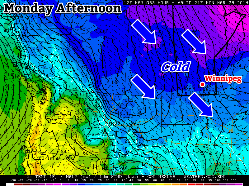
Today will see the continuation of well below normal weather. This morning’s lows were more akin to January than March and today’s highs will be similar to the normal lows for this time of year. That is to say we’ll see highs near the -10C mark, with this morning’s lows having been in the -20s. If the cold wasn’t bad enough, we may even see a bit of snow along a cold front today – just what you were hoping for I’m sure. This cold front will usher in some gusty north-west winds too, so any snow that does fall will be sure to blow around a bit.

Tuesday

Tuesday
-11°C / -20°C
Mainly Sunny

Tuesday will be similar Monday temperature-wise with temperatures once again well below normal. It will be a bit less windy than Monday however, with little threat for snow, which will make it slightly nicer day overall.

Wednesday

Wednesday
-6°C / -10°C
Flurries possible

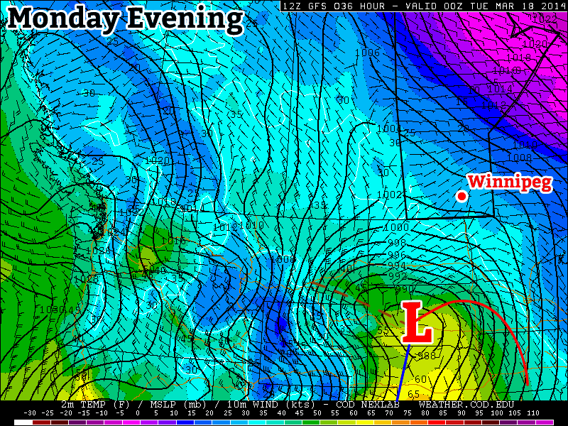
Wednesday looks to be one of the warmest days this week, with highs in the mid single digits. This warmer air will be brought north by a low pressure system passing to our south. This low pressure system may even bring some snow to southern Manitoba, but it’s too early to say.

Long Range

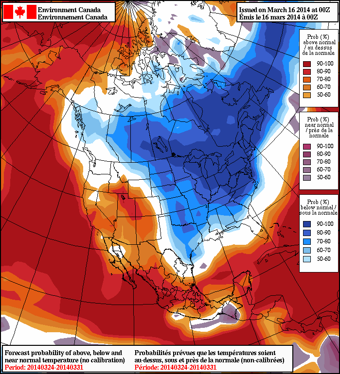
The long range forecast continues to look abominable. Long range models continue to strongly suggest that below-normal weather will last at least through the end of March. At this point we can only hope that April will see some improvement.

Welcome Back, Winter

Below-normal temperatures return for the long haul as yet another Arctic air mass settles in over the province. At least we’ll see some sun.

Friday
⇓ -15°C / -22°C
Clearing & windy.

Saturday
-13°C / -24°C
A few clouds.

Sunday
-13°C / -21°C
Mainly sunny.

If I’m really digging for a positive angle for today’s weather, then we’ll go with the fact that it won’t be quite as bad as it looked like it might be. With last night’s system tracking further south than previously expected, significantly less snow has fallen over the Red River Valley and, thanks to that southern track, the winds today won’t be quite as bad as it had looked.

The main story today will be the temperatures and the wind. Our temperature this morning around -10°C will be about as warm as it gets; strong northwesterly winds to 30-40km/h with gusts near 60km/h will usher in very cool air and result in temperatures dropping through the day to around -15°C. Skies will clear fairly early this morning and then we’ll spend the rest of the day under mainly sunny skies. There may be some blowing snow in the Red River Valley today, but the reduced snowfall and winds, coupled with the warmer temperatures of the past few days, should keep its impact fairly minimal. Under clear skies, temperatures will drop to around -22°C tonight.

Tomorrow will bring mostly sunny skies, albeit with a few afternoon clouds, and a high near -13°C. Temperatures will drop to around -22°C again tomorrow night. Sunday will be another sunny, cool day with a high near -13°C and a low of around -21°C.

This cool weather, while not the bone-chilling temperatures we saw in January and February is still quite remarkable. Daytime highs will be nearly 15°C below normal while overnight lows follow suit at around 10-15°C below normal[1].

Below Normal – Get Used to It

While I’d love to say this cold snap is short lived, apparently winter isn’t quite willing to let spring move in yet. While the extreme departure from normal will only last through the weekend, it looks like (for the most part) we’ll see below normal temperatures right through the end of the month.

Below-normal temperatures are forecast through to the end of March for Manitoba.

Temperatures look to warm up to only around 5°C below normal by the middle of next week, but in general don’t expect to see any prolonged springtime warmth until we get into April.


  1. For March 21st, seasonal daytime highs for sit at +1°C and seasonal overnight lows sit at -9°C .  ↩

Unseasonably Cool Weather Returns

After enjoying a few days with daytime highs near the seasonal 0°C for this time of year, cooler weather is on its way to Southern Manitoba by the end of the week as a late-week disturbance ushers in cooler air as a northwesterly flow returns.

A low pressure system passing through the Northern Plains on Friday will usher in northwesterly winds and cooler weather.

Fortunately, seasonal weather is on tap for the next couple days with little in the way of weather expected. Today will be pleasant with a high near 0°C under mixed skies. Winds will remain calm through the day. Skies will gradually clear tonight as some drier air works into the Red River Valley from the west. Temperatures will drop to around -8 or -9°C.

Thursday will be a pleasant day with cloudier skies and a high near 0°C once again. Winds will be light out of the east. The cloud cover is thanks to an incoming low pressure system that will track out of Southern Alberta into the Northern Plains of the United States and eastwards towards the Great Lakes. At this point, no precipitation is expected through the daytime on Thursday.

Wednesday
0°C / -8°C
Mixed skies.

Thursday
0°C / -10°C
Mostly cloudy. Chance of flurries in the evening & overnight.

Friday
-9°C / -24°C
Mainly sunny and windy.

Colder Weather Arrives Thursday Night

Thursday night will bring a chance for some flurry activity as a cold front slumps through the region. It looks like any snow that occurs will be relatively disorganized and not particularly intense, so no significant snowfall accumulations are expected. Winds will increase to around 20km/h out of the north by the end of the night as temperatures drop to around -9 or -10°C.

The northerly winds will continue on Friday, increasing out of the northwest to around 30-40km/h, marking the arrival of significantly cooler air to the Red River Valley. Temperatures will stay steady or recover only slightly under mostly sunny skies. Winds look to taper off Friday night with the temperature dropping to an overnight low of around -24°C.

Cool Outlook

The NAEFS continues to forecast a high probability of below-normal temperatures in Southern Manitoba.

Unfortunately, it doesn’t look like the cold air is going to go anywhere quickly. Cold air will be entrenched through the weekend giving us daytime highs 10-15°C below normal. By the beginning of next week, the coldest air will shift off into Ontario, however cool air will still remain leaving us around 5-10°C below normal.

The below-normal temperatures are forecast to stick around through most of the rest of March. I suppose we can all take solace that below-normal temperatures in March aren’t nearly as cold as below-normal temperatures in January.

Mild Start to the Week, Stormy to the South

This week will start out with mild weather in southern Manitoba while a major storm system passes just to our south.

A major weather system will pass just to our south on Monday

Monday

Monday
-1°C / -4°C
Increasing Cloudiness. Chance of Flurries.

Today will feature nice weather in southern Manitoba. Temperatures will be near the zero degree mark with light winds. However, just to our south a major storm will be taking shape. This storm is expected to bring heavy snow to the Dakotas and Minnesota. There is still uncertainty about where the heaviest snow will fall, but if you have travel plans into the northern United States early this week you’ll definitely want to check the weather forecast along your route.

Tuesday

Tuesday
-1°C / -10C
Mainly Cloudy

Tuesday will be another mild day in southern Manitoba. Temperatures will once again be near the freezing mark with a light northerly flow. As you might expect, this north wind will be generated by that big storm to the south.

Wednesday

Wednesday
-1°C / -12°C
Mainly Sunny

Wednesday will be another mild day, with temperatures generally just below freezing. We should finally be clear of the storm system from earlier in the week, with clear skies being the order of the day. The wind will be from the north-west, but it won’t be particularly strong.

Long Range

The long range forecast calls for below normal temperatures in southern Manitoba for the end of March

Unfortunately, the long range forecast suggests a return to more wintry conditions for awhile. Most long-range guidance shows cool to cold conditions for the end of March. It remains unclear how the month of April will unfold.