Cooler Weather Returns

After a roller-coaster ride for our temperatures over the past week, cooler weather will settle in over the Red River Valley for the weekend. Temperatures will be around 10°C below normal over the next couple days before warmer & unsettled weather begins to push in by the end of the weekend.

Friday
⇒ -12°C / -23°C
Mixed skies. Winds tapering off this afternoon.

Saturday
-14°C / -23°C
Mainly sunny.

Sunday
-7°C / -12°C
Increasing cloudiness with a chance of snow late day.

Cool, Sunny Start

A ridge of high pressure will build into the Red River Valley through the day today, tapering off the northerly winds and bringing with it cooler air from Northern Manitoba. As temperatures remain steady near -12°C, strong northerly winds at 30-40km/h will diminish to 15-20km/h by the afternoon. Skies will remain mixed through most of the day thanks to some lingering instability behind the cold front that pushed through overnight.

Temperatures will drop to around -23°C tonight as the clouds mostly clear out. Winds will be light out of the north.

Tomorrow looks very similar to today; temperatures may climb a degree or two higher under a partly cloudy sky, but we’ll still be a good 10°C below normal for this time of year. Saturday night’s temperatures will be similar to tonight’s.

Warmer, Unsettled Weather Returning

An update on Sunday’s system is available in the comments below. Click here to jump to it.
Expected snowfall accumulations through Sunday night.
Update: Expected snowfall accumulations through Sunday night.

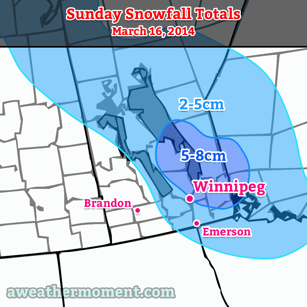
Sunday will bring warmer weather as milder air begins pushing eastwards thanks to another low pressure system set to track from northern Alberta through southwest Manitoba. Temperatures will climb to around -7°C with increasing cloudiness and moderate southerly winds to 30-40km/h. There will be a chance for some light snow here in Winnipeg through the evening and overnight period; amounts are still quite unclear, but it seems likely to be no more than a few centimetres. Cloudy skies will continue through Sunday night as temperatures drop to about -12°C.

Through the beginning of next week it looks like we’ll be returning towards seasonal temperatures[1] with mainly cloudy skies. It looks like there will be multiple chances for snow next week, but at the moment none of them look like significant snowfalls of any sort.


  1. Seasonal temperatures for mid-march are around -2°C.  ↩

Incoming Mild Air Brings Unsettled Weather

A textbook frontal passage is in store for the Red River Valley over the next few days as an incoming warm front brings a chance of flurries and another mild day before the cold front slumps through the region at week’s end, bringing another windy chance for snow.

Wednesday
-10°C / ⇑ -3°C
Cloudy, light flurries starting midday.

Thursday
+4°C / -7°C
Warm with mixed skies. Windy with flurries overnight.

Friday
-6°C / -20°C
Chance of early morning flurries, otherwise mainly sunny.

We’re off to a cold start this morning, but temperatures will soar today as a strong warm front pushes across the Red River Valley. Southerly winds will pick up through the day to around 30-40km/h by mid-afternoon. There will be a chance of flurries beginning midday and lasting through the early evening. No significant accumulations are expected and thanks the warming temperatures and recent melting, blowing snow should be minimal. Temperatures will climb to around -10°C by evening but continue rising through the overnight period to nearly -2°C by Thursday morning.

Mild air is set to push into Southern Manitoba again on Thursday.

Thursday will be another beautiful day very reminiscent of Monday this week. Winnipeg will see relatively light winds and mixed skies as the temperature climbs all the way to 4°C. Similar to Monday, there will probably be significant variation across the city with some places climbing several degrees higher to 7-8°C.

Things will take a less pleasant turn on Thursday night when a cold front slices through Southern Manitoba. Gusty winds out of the northwest to 40km/h will accompany some flurry activity that will spread into the Red River Valley from north to south through the mid-to-late evening hours. The wind and any straggling flurries should taper off early Friday morning.

Friday sees an Arctic ridge of high pressure building into Manitoba bringing cooler temperatures with it. In Winnipeg, temperatures will be some 10°C cooler than Thursday with a daytime high only near -7 or -6°C under mainly sunny skies.. Winds will remain light and the temperature will drop close to -20°C on Friday night.

Cool Weekend Ahead

Temperatures will remain well below normal through the weekend in the Red River Valley. Saturday’s high looks to be near -15°C under mainly sunny skies while Sunday sees the coldest axis of air shifting off to the east, allowing temperatures to climb to the low minus single digits with a few cloudy periods.

In the southwest corner of the province, flurries will be possible numerous times over the next 5 days as the main frontal zone sets up across the region and weak disturbances ripple along it.

Warmer for Awhile

We’ll continue to see warm weather persist this week, but our snow won’t be disappearing any time soon.

Warm air will move across the Prairies on Monday

Monday

Monday
3°C / -10°C
Mix of Sun and Cloud

Today will be one of the warmest days this week. High temperatures will edge above zero as a brisk westerly wind allows Pacific air to pour into Manitoba. Naturally, there will be some melting today, but it will do little to dent the massive snowpack in the region.

Tuesday

Tuesday
-7°C / -17°C
Mainly Cloudy. Chance of Flurries.

A high pressure system will slide down from the arctic on Tuesday, bringing a temporary return of chiller weather. It won’t be cold by any means, but it will be cool enough to halt the snow melt. There may be a few flurries around due to the presence of low cloud.

Wednesday

Wednesday
-2°C / -4°C
Mainly Cloudy

A strong southerly flow will develop in southern Manitoba on Wednesday, signaling a return to warmer conditions. Wednesday will be a fairly mild day, but those gusty south winds will make it feel quite a bit cooler than it would otherwise seem.

Long Range

The long range forecast is somewhat ambiguous at this point. Long-range weather prediction models are struggling to figure out what type of weather we’ll see for the rest of March. It appears the most likely outcome is an up and down pattern, with periods of mild weather followed by periods of colder weather. Thankfully, there is no sign of a return to the extreme cold we experienced at the beginning of the month.

A Sunny Reprieve

After being inundated with disturbance after disturbance and many areas in the province seeing a fresh 10-20cm of snow, a ridge of high pressure is building into the region and will bring a benign break from the snow at the cost of slightly cooler temperatures.

Friday
-10°C / -22°C
Clearing early & breezy.

Saturday
-9°C / ⇑ -7°C
Mainly sunny.

Sunday
+1°C / -5°C ⇑
Partly cloudy.

Skies will clear early this morning as breezing northwesterly winds – at 30-40km/h – draw in cooler air to the Red River Valley. Here in Winnipeg we’ll see a high around -9°C. Temperatures will drop into the -20’s tonight as we sit under that ridge of high pressure mentioned above. Saturday will bring mainly sunny skies with a high near -8°C and winds around 15-20km/h shifting to be out of the southwest.

Saturday night will drop to only around -10°C early in the night and then warm up to around -7°C as warmer air starts pushing into Manitoba from the west. We’ll enjoy a warm day with cloudy periods on Sunday as temperatures climb above the freezing mark to +1°C. Temperatures will fall only around -5°C thanks to cloudy skies overnight.

Those cloudy skies Sunday night will be the result of low pressure system pushing across the Prairies. It will bring the potential for some shower or flurry activity to Winnipeg on Monday, however the bulk of precipitation looks to remain further north.

Overall, a nice weekend ahead! Get out there and enjoy it!