Small Warm-Up

We’ll see warmer conditions for the beginning of this week. Temperatures may even climb above normal!

Shower activity on Monday

Light rain over parts of Manitoba on Monday

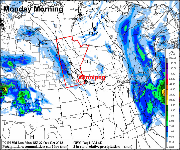
While Sandy hits the eastern coast of the United States hard during the early part of this week, the weather in Southern Manitoba will be very quiet. Temperatures on Monday will be in the mid to upper single digits in Southern Manitoba, which is near to slightly above the average daytime high of 5C. In terms of precipitation, a passing upper-level disturbance on Monday will generate cloud and some light showers in Southern and Central Manitoba. The most favoured area for shower activity is Western Manitoba, though other parts of Southern Manitoba stand a small chance of seeing a light rain shower. On Tuesday a passing trough of low pressure may once again generate a few showers, though they will be very light and scattered in nature. Tuesday’s high temperatures will be very similar to Monday’s, once again being in the mid to upper single digits.

Halloween Wednesday will be a chilly day, as cool north-westerly winds flow out of a surface ridge over Saskatchewan. Temperatures during the daytime will only be slightly above zero, but will drop near to or slightly below zero by the trick or treating hours. No precipitation is expected on Wednesday.

Conditions through late week will remain fairly seasonable, with daytime highs hovering near to or slightly below 5C. No major shifts in our weather are expected in the foreseeable future. In general, seasonable to slightly below seasonal values are expected over the next while.

Cool Weekend Ahead

Arctic air will keep temperatures cool through the weekend with daytime highs some 5-7°C below normal. Scattered flurries will be common through the weekend, while a significant lake-effect snowfall event will impact portions of the Whiteshell and Eastern Manitoba.

850mb Temperatures Valid Saturday Morning

850mb temperatures valid Saturday morning. A deep pool of Arctic air will flood across the Prairies this weekend.

As the low that brought rain to Southern Manitoba the past few days pushes northwards into Hudson Bay, it will intensify quite considerably1 and induce a strong northwesterly flow over the Canadian Prairies. This cold air will likely produce isolated scattered flurries, however the largest effect will be strong lake-effect snow bands, primarily from the basins of Lake Winnipeg. These lake-effect bands will mainly effect the Bisset region and slowly push northwards towards Berens River as the winds back slightly to westerly through the weekend. Substantial amounts of snow are possible with these bands, with the potential for anywhere from 15-30cm of snow possible in areas that see a band have a particularly long residence time over them.

Daytime highs over the next few days will sit within a degree or two of 0°C, with overnight lows near -6 or -7°C. No significant improvement in temperatures is expected until potentially early next week as a low pressure system moves through the Central Prairies and brings ever so slightly warmer air back to the region.


  1. It’s currently forecast to deepen from a 982mb low this morning to a 967mb low tomorrow morning. 

Cooler Air Pushing Southeast Across Southern Manitoba

The powerful low pressure system that has brought rain to Winnipeg over the past couple days and is bringing 10-20cm of snow to portions of Northern Manitoba has pushed north and east of the Red River Valley, setting the stage for cooler air to filter into the region.

700mb Temperatures for Thursday Morning

NAM forecast of 700mb heights & temperatures valid Thursday morning.

The Red River Valley will be moving into a strong northwesterly flow aloft that will advect cooler air into the region. While earlier in the week, models were projecting a very potent arctic blast, things have become a little more pleasant due to a more significant amplification of the upper-level pattern. The net result of this is a cut-off upper low over the central Prairies that will, in effect, block the coldest air from being able to push southwards. This will give us more cloud than sun with daytime highs near 5 or 6°C through the rest of the work week.

The upper low begins to push eastwards for the weekend, allowing slightly cooler temperatures to the area for the weekend, with highs near 0°C, and a chance of some light snow. Accumulations will be light-to-none throughout the RRV, however a few cm may pile up in the Interlake region.

More Active Weather

More active weather is in store for this week with multiple chances for precipitation. The question is whether that precipitation will be solid or liquid.

Low pressure system passing to the south-east on Thursday

A low pressure system is currently expected to pass to our south-east on Thursday, generating minimal impacts in Manitoba

The weather to start the week will be fine, with temperatures generally in the high single digits on Monday and perhaps a few double-digit readings here and there. There will be increasing cloudiness during the day as a weather system approaches. This system will begin to spread rain over Southern Manitoba on Monday night with precipitation persisting into the day on Tuesday. Highs on Tuesday will remain very similar to Monday, but the rain will make it a considerably more miserable day. Total accumulations from this system will generally range from 5 to 15mm. As Tuesday’s system departs our region on Wednesday, cooler air will sweep in from the west making for a chilly and windy middle of the week. Temperatures on Wednesday will be in the mid single digits with a gusty west wind.

There has been much talk about the weather for later this week. Some models have been showing a significant Colorado Low system hitting portions of Manitoba on Thursday and Friday. However, other models show little or no precipitation for us later this week. At this point the consensus seems to be that it is unlikely Southern Manitoba will be getting a major blizzard later this week. Most models depict a moderate strength low system sliding past us through Minnesota and up into North-Western Ontario, perhaps bringing a few flurries or rain showers to Southern Manitoba, but not a major winter storm. Some models still show a fairly deep low pressure system to our east over Northern Minnesota and North-Western Ontario later this week, but it looks like it will be sufficiently far away to prevent us from seeing its main impacts. So at this point it appears unlikely that we’ll be seeing any significant amount of the white stuff later this week. However, expecting the unexpected as always a good saying to live by in the weather business.