Pleasant Start to the Weekend, Rainy End

After unsettled weather moves through this morning, Winnipeg will enjoy a pleasant start to the weekend. On Sunday, unsettled weather will return as the next disturbance moves into the province.

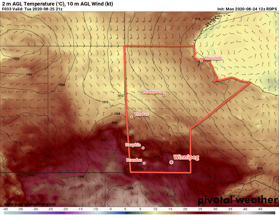
Today will start with a cold front pushing through the region early this morning. As it moves through, it will push a line of showers and thunderstorms southeastwards across the region. Behind them, skies will clear and northwesterly winds will strengthen into the 30–40 km/h range for the rest of the day. These winds will usher in a return to seasonal temperatures and Winnipeg will see a high of just 22 °C this afternoon.

A ridge of high pressure moving into the province will bring cooler temperatures into the province tonight. Winnipeg will see a low near 10 °C under clear skies with winds gradually easing.

That ridge will also give Winnipeg plenty of sunshine on Saturday. With light winds and mainly sunny skies, the city will see temperatures climb to around 23 or 24 °C. Heading into Saturday night, an approaching complex of low pressure will strengthen southeast winds into the 20–30 km/h range. These winds will help keep temperatures a bit milder with a low near 13 °C.

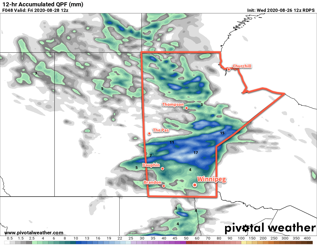
On Sunday, the approaching disturbance will spread cloud into the region as temperatures climb to a high near 23 °C. Forecasts show a broad area of rain developing in the afternoon, producing widespread amounts of 10–25 mm of rain across the Red River Valley by the time it tapers off overnight. Locally higher amounts may end up possible depending on how much elevated instability develops over the region.

NAM 24hr. Precipitation Accumulation Forecast valid 12Z Monday August 31, 2020
Much of southern Manitoba is forecast to see accumulating rainfall on Sunday afternoon and night.

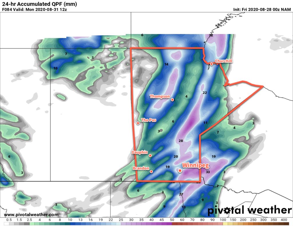
Along with the rain, it will be a breezy day as well. The southeasterly winds will persist through the day before switching to the northwest in the evening behind a passing cold front.

Temperatures will dip to a low near 11 °C on Sunday night under mostly cloudy skies as the rain tapers off.

Long Range Outlook

Next week looks to bring a spell of seasonably cool weather. Winnipeg will see mixed skies through the week with daytime highs in the upper teens or low 20s. Overnight lows look to hover near a seasonal 10 °C. Some rain is possible mid-week as a couple disturbances are forecast to move through southern Manitoba.

Today’s seasonal daytime high in Winnipeg is 23 °C while the seasonal overnight low is 10 °C.

A Return to Seasonal Temperatures

A large-scale pattern change will bring an end to the prolonged summer heat alongside cloudier conditions.

Winnipeg will see a cloudy start to the day with northwest winds around 20 km/h. After a cloudy morning, the sun should make an appearance for the afternoon, helping it warm up to a high near 25 °C. Winds will diminish tonight as an area of high pressure builds across the province. The city should see a low near 11 °C under clear skies.

On Thursday, Winnipeg will enjoy a sunny start to the day, but an approaching low will begin to spread cloud into the region in the afternoon. Temperatures will reach a seasonal high near 24 °C. On Thursday night, the Saskatchewan low will push into Manitoba. Its arrival will keep skies mostly cloudy through the night and bring rain through WestMan and the Interlake. For Winnipeg and the RRV, it will bring a chance of showers after midnight. Temperatures will dip to a low near 15 °C.

RDPS 12hr. Precipitation Accumulation Forecast valid 12Z Friday August 28, 2020
A low pressure system crossing the province on Friday night will bring rain across the Interlake and showers to southern Manitoba.

On Friday, a few showers are likely in the morning as a cold front pushes through the region. In its wake, northwest winds will strengthen to 30 gusting 50 km/h as skies clear. It will mark a return to seasonal temperatures in Winnipeg with a high near 22°C. Temperatures will dip to a low near 11 °C on Friday night with the winds easing off.

Long Range Outlook

The weekend will bring a mixed bag to the region with near seasonal temperatures. Winnipeg will see highs in the low to mid-20s both days with overnight lows of 10–15 °C. Saturday should bring mainly sunny skies to the region, but another low moving through on Sunday may bring rain and/or thunderstorms to the region into Monday. Next week will bring variable cloudiness and highs near 20 °C.

Today’s seasonal daytime high in Winnipeg is 23 °C while the seasonal overnight low is 10 °C.

Summer Warmth Continues

Winnipeg will see summer warmth continue through the first half of the week followed by a return to more seasonal temperatures.

Winnipeg will see mainly sunny skies today courtesy a ridge that extends south through Manitoba from a high near the 60th parallel. With light winds, temperatures will climb to a high near 29 °C this afternoon. Along with the warmth, humidity levels will stay comfortable and make for a beautiful afternoon. Temperatures will dip to a low near 15 °C tonight with clear skies.

On Tuesday, temperatures will again climb to a high near 29 °C but a warm front will spread cloud into the region through the day. There will be a chance of scattered showers as the warm front passes midday, and again as a cold front sweeps southeast on Tuesday night. After the warm front pushes through, winds will increase out of the southeast to 30–40 km/h for the afternoon. The winds will ease after midnight, then pick up out of the northwest with the cold front early Wednesday morning.

RDPS 2m Temperature Forecast valid 21Z Tuesday August 25, 2020
Winnipeg will see another warm day on Tuesday before cooler, more seasonal temperatures move in for the second half of the week.

With both the warm and cold fronts, there will be a chance of a thunderstorms. The environment will not likely support a widespread severe weather threat, but isolated severe thunderstorms may be possible. If any severe thunderstorms develop, the primary threat associated with them would be large hail and damaging wind gusts. For any thunderstorms at night, the primary threat will be hail.

On Wednesday, northwest winds will persist at 20–30 km/h through the day and usher in more seasonal temperatures. Skies will be on the cloudier side through the morning, but should clear out for the afternoon. Winnipeg will see a high near 25 °C in the afternoon and a low near 13 °C on Wednesday night.

Long Range Outlook

A cooler air mass will move into the region for the second half of the week. Winnipeg will see highs cool to the low 20s and lows to the mid- to low teens. Skies will be variably cloudy through the second half of the week with another chance for showers or thunderstorms later Thursday.

Today’s seasonal daytime high in Winnipeg is 23°C while the seasonal overnight low is 10°C.

Warm Weather Continues With A Chance of Thunderstorms

The warm temperatures will continue in Winnipeg right through the weekend, but a couple disturbances moving through will bring several chances of showers or thunderstorms to the region.

Temperatures will soar back into the low 30s in Winnipeg today with slightly humid conditions. Mainly sunny skies this morning will give way to increasing cloud this afternoon as a disturbance approaches the region this afternoon. By mid-afternoon, the Red River Valley will begin to see a chance of thunderstorms spreading eastwards. Today’s storms could produce severe weather across the region; the main threats will be torrential rainfall and large hail, but isolated severe wind events will also be possible. While a tornado is possible today, it will not be a primary threat.

3km NAM Forecast Simulated RADAR Reflectivity valid 00Z Saturday August 22, 2020
Most forecasts show a line of thunderstorms entering the Red River Valley by 6 PM.

Showers or thunderstorms will continue to be possible into the night, although the chance is significantly less after midnight. Temperatures will dip to a low near 18°C.

Severe Weather Setup

Friday will pose a notable severe weather threat over southern Manitoba. The triggering weather feature will be a trough of low pressure pushing eastwards through the region. The thermodynamic environment will be favourable for severe weather. Surface dew points in the 17–18 °C range will support MLCAPE values near 2000 J/kg. There is a bit of uncertainty with the moisture depth, but mid-level drying between 700 and 500 mb will also support storm development.

Dynamics are a little less favourable, though, with a disjointed veering hodograph with relatively light winds. Bulk shear (0–6 km) values are forecast to sit around 25 knots, marginally supportive for severe storms. Thunderstorms will struggle with weak mid-level winds, though, and will have to rely on broader synoptic support to get organized.

Precipitable water is forecast to sit in the 30–40 mm range, high enough o support torrential rainfall. Fortunately, storm motion is forecast to be 25 to 40 km/h. Thunderstorms won’t likely be sitting over any one location for too long.

SHARPpy Forecast 3km NAM Sounding for Winnipeg valid 00Z August 22, 2020
Most forecast soundings show a moderately unstable environment by late Friday.

All this combines to produce a primary threat of damaging hail, supported by large MLCAPE values, marginal shear, and the potential for a favourable dry layer in the mid-levels. Torrential rainfall is also a threat but thunderstorms will likely be moving quickly enough that any one location won’t see problematic accumulations.

Damaging wind gusts will be a secondary threat, but will only be possible if thunderstorms are able to organize enough to produce upscale growth into some sort of MCS. In that case, wind profiles would support the potential development of bow echoes and the associated damaging winds. Lastly, a tornado is possible but would require extensive local-scale modification to the dynamics by a strong thunderstorm. The synoptic support resembles something that could support tornadoes, but a lot of the details aren’t entirely right. That said, be sure to keep watch for any alerts issued by Environment and Climate Change Canada later today for any potential severe weather.

The Weekend

Aside from the chance of an early morning shower, Saturday should be a dry day. Skies will start out fairly cloudy then gradually clear midday into the afternoon. By the evening, Winnipeg should see plenty of sunshine with temperatures in the upper 20s. The city will see a low near 16°C on Saturday night with mainly clear skies.

On Sunday, another surge of warmer air followed by a cold front will move through the region. Winnipeg should see a high back near 30 °C with partly cloudy to mixed skies. As the cold front pushes into the region in the afternoon, a chance for showers or thunderstorms will spread into the Red River Valley and persist into the evening hours. The cloud cover will break up overnight with a low near 16°C.

Long Range Outlook

Next week will bring a return to near-seasonal temperatures. Daytime highs will hover in the mid-20s with overnight lows cooling to the low teens. A zonal flow aloft will develop, meaning the region will see a fair amount of sun, but occasional disturbances bringing showers and thunderstorms will be possible.

Today’s seasonal daytime high in Winnipeg is 24°C while the seasonal overnight low is 11°C.