Mild Weather Continues

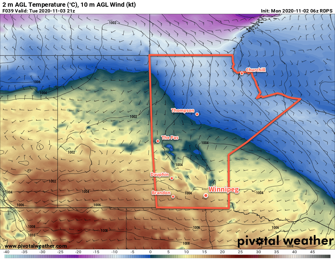
Warm temperatures will continue in Winnipeg as a slow-moving upper ridge continues its trek eastwards across the Prairies.

An upper ridge over the Prairies is bringing mild conditions to Winnipeg with plenty of sunshine. WIth the storm track deflected well to the north, the city will see dry conditions over the coming days. It will be easy to enjoy the late-fall warmth!

Winds will stay relatively light today out of the west up into the 20–30 km/h range. On Thursday, though, a low crossing the northern Prairies will strengthen winds in the Red River Valley out of the south into the 30–40 km/h range. On Friday, the city will likely see light winds to start the day then pick up out of the northeast as a large low complex begins to develop in the United States.

RDPS 2m Temperature Forecast valid 21Z Wednesday November 4, 2020
Much of southern Manitoba will see mild temperatures with daytime highs in the upper teens on Tuesday.

Overnight lows will also be mild over the coming nights with values in the low to mid-single digits.

Long Range Outlook

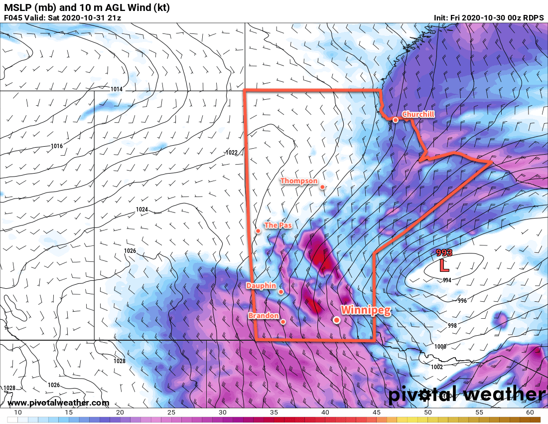
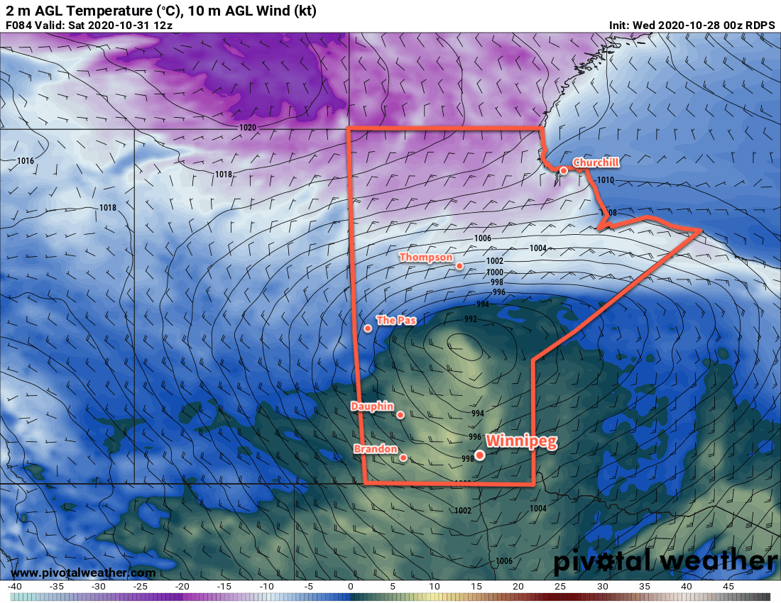
As we mentioned on Monday, a potent Colorado Low is forecast to develop this weekend and move into the southern Prairies. Forecast models are beginning to gather some consensus on the track of the system, trending towards a track that takes the low across southeast Saskatchewan on Sunday, western Manitoba on Sunday night, and northeastwards towards Hudson Bay on Monday.

This system will likely produce a swath of 20 to 50 cm of snow on its western and northern flanks, which would put it across southern Saskatchewan northeastwards into west-central Manitoba and onwards to Hudson Bay. This heavy snow combined with winds gusting up to 80 km/h would likely produce widespread blizzard conditions across the affected areas.

ECMWF Forecast Precipitation Type/Rate valid 00Z Monday November 9, 2020
All major forecast models have a potent winter storm moving into the Prairies on Sunday.

To the south and east of this low track, some light snow or rain is possible, as well as the potential for a broad area of low cloud and drizzle. Temperatures could stay rather warm in the southeastern quadrant of the storm with highs potentially climbing into the low teens.

Regardless of the storm track, this system will usher in much cooler weather for next week with daytime highs dropping below freezing for the rest of the week.

Today’s seasonal daytime high in Winnipeg is 2 °C while the seasonal overnight low is -6 °C.

Beautiful November Weather Ahead

The forecast is short and sweet to start the week: sunny and warm!

A broad upper ridge building across the Prairies has finally arrived in southern Manitoba. As a result, it will bring plenty of sunshine as temperatures climb into the low teens right through the next few days.

RDPS 2m Temperature Forecast valid 21Z Tuesday November 3, 2020
The southern Prairies will enjoy a late-year warm spell with temperatures in the teens across much of the region.

Winds will also be light through the coming days, generally no more than 15–25 km/h.

There really isn’t much to say! Enjoy this nice stretch of mild November weather!

Long Range Outlook

Conditions will turn cloudier towards the end of the week as the upper ridge begins to collapse and a couple lows track across the central Prairies. Temperatures will stay warm until Thursday, then begin cooling towards seasonal values.

Weather models are all showing a fairly potent winter storm developing this weekend in the form of a Colorado Low. There is still a large discrepancy on the track of the low, but there is good agreement that this storm could bring 20 to 30 cm of snow along a swath somewhere through the southeastern Prairies.

While there’s little agreement in where the snow will fall right now, but regardless of that, this system will usher in much cooler conditions for next week. Daytime highs will fall back below seasonal values through the first half of the week.

Today’s seasonal daytime high in Winnipeg is 3 °C while the seasonal overnight low is -6 °C.

Windy Weather Ahead

Winnipeg’s first effort at milder temperatures will come with plenty of cloud and wind, but sunnier and warmer conditions are likely next week.

Warmer weather will build into the region today ahead of a low pressure system forming over Alberta. Skies should stay mostly cloudy today as the low gathers steam and pushes into Saskatchewan. Temperatures in the city will climb to a high near +2 °C this afternoon. As the low begins moving towards the province this evening, southerly winds will strengthen up to 40 gusting 60 km/h and persist through the night. With cloud cover and moderate southerly winds, temperatures will stay fairly steady with a low near +1 °C.

On Saturday, the low will cross through the province, bringing the warmest air with it. Th wind will ease for the morning with temperatures reaching a high near +4 °C. A potent cold front will sweep through the region midday, ushering in strong northwest winds up to 50 gusting 70 km/h. A chance for midday rain will quickly change to a chance of snow as temperatures drop in the afternoon. The chance of light snow will continue into the evening, then end as a ridge moves into the area. Skies will clear out overnight with temperatures heading to a low near -8 °C.

RDPS 10m Wind Forecast valid 21Z Saturday October 31, 2020
Strong northwest winds will develop over southern Manitoba on Saturday.

Warmer air will already be pushing back into the area on Sunday as a broad upper ridge begins building across the Prairies. The city should see a high near +2 °C with partly cloudy skies. South-southwest winds will pick up through the day into the 20–30 km/h range, then gradually ease overnight. Temperatures will fall to a low near -2 °C on Sunday night under partly cloudy skies.

Long Range Outlook

The upper ridge will continue building across the Prairies through early next week, ushering in a warmer air mass. It looks likely that daily highs may climb up into the 8–12 °C range for a few days, but one unknown is how much low-level cloud the snowpack may generate as the warmer air arrives. In some cases, extensive stratus development can keep temperatures near the surface hovering close to the freezing mark.

We’ll have to wait and see, though, how much of an impact this has. If the winds are able to keep enough of a westerly component to them, they should stay dry enough to scour out any moisture from melting and keep the sun shining through.

Near-seasonal temperatures are forecast to return near the end of the week.

Today’s seasonal daytime high in Winnipeg is 4 °C while the seasonal overnight low is -5 °C.

Temperatures Trending Milder in Winnipeg

Milder weather will gradually build into the region over the coming days, but cloud cover will limit potential warmth.

The tail end of the weather system that brought snow to the region yesterday will move through the Red River Valley this morning, bringing with it a good chance of some rain showers or flurries. The precipitation should end by mid-morning followed by northerly winds of 20–30 km/h and a high of +1 °C. Skies will become mixed in the afternoon, then mainly clear in the evening. The winds will ease tonight with temperatures heading to a low near -11 °C as an Arctic ridge slides through.

On Thursday, skies will become increasingly cloudy with a light southerly wind. Temperatures will still be a bit cooler with a high near 0 °C as Arctic air lingers a bit longer in the region. Temperatures will head to a low near -5 °C on Thursday night with mixed skies.

RDPS 2m Temperature Forecast valid 12Z Saturday October 31, 2020
A strong low pressure system is forecast to push warmer temperatures into the region on Friday night.

A strong low pressure system will begin moving across the Prairies on Friday, pushing a warmer air mass across the southern Prairies. Unfortunately, an expansive area of cloud moving through the region will limit temperatures. Winnipeg will see a high of only 2 or 3 °C with southerly winds increasing to 30 gusting 50 km/h by the evening. These moderate southerlies will continue through the night as the low approaches. The region will see a chance of rain showers overnight with a low near +1 °C.

Long Range Outlook

Saturday will bring more cloud cover as the low continues moving through the region, along with another chance for some rain or snow. Temperatures will reach a high near +4 °C, but then a cold front will sweep through and usher in brisk northwesterly winds and a brief return to cooler temperatures. Sunday should bring mixed skies with a high in the low single digits.

Another push of warm air is forecast for the beginning of next week and the region could see daytime highs in the 7 to 10 °C range for the first half of the week.

Today’s seasonal daytime high in Winnipeg is 6 °C while the seasonal overnight low is -4 °C.