Southeast US Paralyzed by Storm
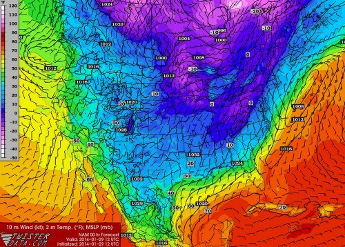
On Tuesday a large trough was in place over the eastern half of the US. The longwave trough extended all the way down to the southeastern states and brought adverse weather conditions along with it. This trough did not produce the typical severe weather the southeast would see around this time of the year; thunderstorms and flooding rain, but produced an event featuring snow, ice pellets and freezing rain.
Arctic air flooded in behind the cold front all the way down from Texas to the Gulf of Mexico to Florida, providing good environment for freezing precipitation right behind the front. Freezing rain fell as far south as Pensacola in the Florida panhandle where over 200km of interstate had to be shut down because it was deemed to be too dangerous for travel. The last time Pensacola saw snow was 2010 – it melted the same day it fell. In comparison, Atlanta saw a trace of snow in 2008. This time around the city received 6cm, which snarled traffic on the commute back home. Officials decided to not cancel schools and students were stranded in schools and buses overnight until the next morning. Commuters were in the same situation, being stranded on roads overnight as many commuters are not accustomed to winter weather leading to many accidents. The sub-freezing temperatures across the Deep South also wreaked havoc, bursting water pipes above ground.
Medium range models continue to show cold air entrenched across the Canadian Prairies and most of the United States, even infiltrating into the Deep South again next week. A persistent ridge off the West Coast, partially associated with the well above normal temperatures in the North Pacific, can be blamed for the persistent troughing and Arctic air over Canada and US the past few weeks. Longer range models do show the ridge eventually breaking down in a week but this remains to be seen as it’s still a long ways out.