Elsewhere in Weather News: December 13th, 2014

West Coast Hit With Strong Winds, Heavy Rains

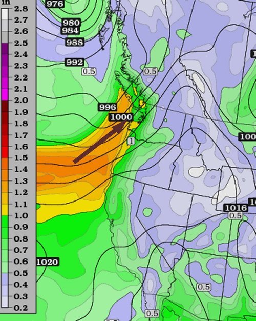
The West Coast of North America has been subject to several systems after coming onshore in the past couple weeks, bringing with them heavy rains and strong winds which has led to flooding. Once again, the culprit for the moisture-laden systems in this region has been the atmospheric river. This atmospheric river is a term used for streams of moisture typically originating in the tropics, which head Poleward. Eventually the water precipitates out – it is often enhanced along the west coast due to orographic precipitation, leading to flooding.

Higher PW values streaming from the tropics to the Californian coast are associated with the atmospheric river. (Source: CIMMS)

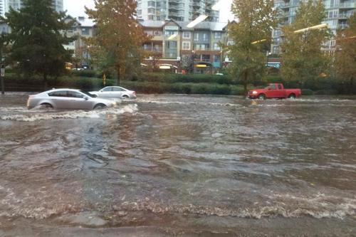
Earlier this week, the BC coast was hardest hit where over 400mm fell on parts of Vancouver Island in 6 days. Flood watches were issued as towns on the Island watched waters rise. The towns of Courtenay and Port Alberni were soaked with over 150mm by Wednesday – some residents were forced to evacuate their homes due to the rising waters. Strong winds were also a problem; gusts over 100km/h were recorded across the coast, even in large cities such as Portland, OR. These winds knocked out power to roughly 75,000 residents in BC alone. In addition to the wind and rain, landslides also became of concern in Southern California. Saturated grounds led to a large slide in Camarillo Springs, CA, which affected over a dozen houses.

Estimated rainfall along the BC coast from December 4 to the 10th. (Source: Environment Canada)
Estimated rainfall along the BC coast from December 4 to 10. (Source: Environment Canada)

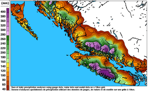
The system even brought a weak EF-0 tornado which was spun-up in one of the stronger rain bands that came onshore. The tornado passed through a small area in southern Los Angeles yesterday morning and stripped roofs of their tiles – no one was injured thankfully. Reports of 60-100mm were common along the Californian coast, but localized amounts of 200mm or higher did occur. The highest precipitation report as of Friday came from an area in the northern Sierra Nevada Mountains where 450mm of precipitation fell; the amounts here were enhanced by orography.

Unfortunately models are showing another system impacting most of the West Coast early next week, not leaving much time for things to dry out.

Elsewhere in Weather News: October 26th, 2014

Vancouver Sees Significant Rain Event

The city of Vancouver has seen its fair share of rainfall this past week, causing flooding problems throughout the metro. What was to blame for this event was an atmospheric river that came onshore the BC Coast, aided by a large upper level trough off the West Coast on Wednesday. Atmospheric rivers are narrow plumes of significant moisture which originate from the subtropics and flow from the southwest onto the shores of the west coast. On Wednesday morning fairly high PWAT[1]
values (>1”), a product of the atmospheric river, nosed into the Vancouver region which set the stage for the heavy rainfall event.

Atmospheric river making its way onto Vancouver island. (Source: Twisterdata)
Atmospheric river (high PWAT values) making its way onto Vancouver island. (Source: Twisterdata)

The rainfall started early Wednesday morning for Vancouver, including a thunderstorm that went through the city around 7am dropping heavy rain. With already saturated soil from the rain earlier in the week, flooding problems ensued. Metro Vancouver saw anywhere between 20-35mm, and pockets of locally higher amounts Wednesday. This event comes a day after the same system offshore brought very strong winds (gusts >100km/h) to Vancouver Island as well as downing power lines and snapping trees in metro Vancouver. It was reported that Tuesday night a total of 80,000 people in southern BC were without power at some time.

Flooding in Port Moody, just east of Vancouver, on Wednesday. (Source: Port Moody Fire Rescue)

As this mid-week system departs, it makes way for the next system upcoming system this weekend. This will be yet another fairly strong system to impact the west coast, bringing with it more heavy rains and strong northwest winds. Unfortunately, unsettled weather is expected to last for the Vancouver region into next week.


  1. PWAT stands for precipitable water, a measure of the amount of water contained in a column of air.  ↩