Elsewhere in Weather News: August 2nd, 2014

Weak Storm Forms in the Atlantic; Typhoon in Pacific

The second named storm of the Atlantic hurricane season spun up this past week and is still churning in the Caribbean. Tropical storm Bertha had sustained winds of around 80km/h as of Friday evening but had lots of dry air to its south and was not very well organized. By this evening it is expected continue its northwest track and pass between Puerto Rico and the Dominican Republic, bringing with it heavy rains as its primary threat. As much as 250mm of rain can be expected in the area which is a cause for concern in the mountainous regions. However, Puerto Rico has been experiencing drought for the past few months; the rain in the forecast is actually a welcome sight. On Sunday Bertha will have more of a northward track, curving up the Gulf Coast and likely dying off to the west of Bermuda due to cooler sea surface temperatures. None of the weather models show Bertha strengthening into a major hurricane and the US mainland is not expected to be impacted by this storm.

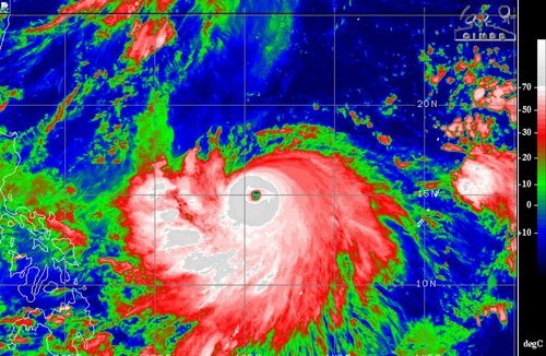
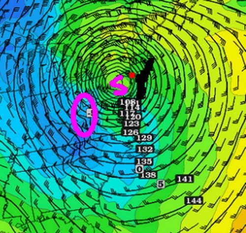
A large, more dangerous tropical disturbance has formed in the western Pacific this week and is already of category three status with sustained winds of 185km/h. Halong has a well-defined eye and eyewall in place, the only thing currently interfering with its development is some dry air to its north. The typhoon is currently located well east of the Philippines and is expected to be of no threat to the country as it will quickly curve Poleward this weekend. It, however, could pose a significant threat to Japan and China next week as it moves into the East China Sea as a strong typhoon. The islands of Okinawa could be in for a strong storm, as depicted by some models, but it is really too early to say for sure.

Typhoon Halong could become a super typhoon if it continues to strengthen at the rate it has been going. IR image taken Friday night.(Source: CIMSS)

Elsewhere in Weather News: October 27th, 2012

Hurricane Sandy – A Unique Storm

Even though hurricane season might be nearing the “official” end (November 30th), the largest and most threatening storm of the year is yet to come. This past week, what could be a historical hurricane for the United States, spun up in the south-east Caribbean and has already caused major damage to surrounding countries such as Cuba, the Bahamas and Haiti.

After initially making landfall near Kingston, Jamaica as a category one (winds of 130km/h), Sandy quickly skipped across the island to make a second landfall on the north-east side of Cuba, leaving significant damage in its wake. In Jamaica about 70% of the island lost power, curfews were issued and all public services closed until the coming week. Three lives were lost in Jamaica and the damage was significant; roads washed out and banana farmers reporting losses to over 50% of their crop. Haiti and the Dominican Republic were not left untouched either, with severe flooding in the deforested regions – it was predicted that widespread rainfall accumulation ranged between 200-255mm. Unfortunately, 10 deaths were related to Sandy in Haiti and three in the Dominican Republic, mainly due to extensive flooding.

Jamaica storm surge

House in Kingston, Jamaica gets inundated by water associated with Sandy’s storm surge. (Source: AP)

Sandy, fuelled by very warm waters, quickly strengthened to a category 2 hurricane between Jamaica and Cuba. With a second landfall in north-eastern Cuba, Sandy brought more grief as it ripped roofs off homes and damaged local coffee and tomato crops. It was also reported from Cuban state media that the hurricane was blamed for 11 deaths in the country.

Continuing its track, though now weakened to a category one hurricane, Sandy moved in a north north-easterly fashion into the Bahamas where similar damage to what was observed in Jamaica occurred as well as an additional three deaths.

Earlier in the week some weather models showed Sandy curving out to sea after moving out of the Bahamas, thanks to a large trough swinging through the Eastern US. Unfortunately, this will not be the case and all of the models now show a landfall somewhere on the East Coast – more precisely somewhere between Maryland and Southern New England. With Sandy being an unusually large storm, tropical winds spanning 450km from its centre, this storm will have to be taken very seriously by residents in the concerned area on the East Coast. The biggest problem with Sandy is that as it nears landfall, its south-easterly flow in the top-right quadrant of the storm will bring significant storm surge to the areas north and north-east of the storm. Models also predict up to 250mm of rain in some areas along the coast and sustained winds that will be at or near tropical storm force extending a significant distance out from the centre of the storm. The storm will also bring large amounts of snow into higher elevations of West Virginia. A state of emergency has been issued.

Sandy

GFS 850mb analysis of Sandy at 7am Tuesday morning, shortly after it makes landfall. Circled area is area most likely to have high snow accumulation, red square is New York City and black shoreline is the area at risk for severe storm surge. (Source: Twisterdata)

Most models predict a landfall on the East Coast just south of New York Tuesday next week, with lasting effects for many days. Updates will be forthcoming as the event unfolds this coming week.