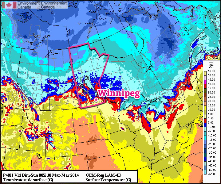
Clipper System Brings Brief Warm-Up

Temperatures are forecast to rise above 0°C by Saturday evening.

A low pressure system moving through the region on Saturday will bring a chance of snow and only slightly below normal temperatures to Winnipeg, however another Arctic ridge will plunge southwards behind the system returning us into the icy grip of winter as temperatures fall 10 to 15°C below normal. This is starting to look very similar to last year: the winter that wouldn’t quit, until suddenly it did. This December to March period will go down as one of the top 15 coldest on record, and not a single one of those top 15 coldest winters was followed by a notably above-normal April[1]. This means while milder weather is on tap, we’ll likely only be looking at returning to near-seasonal averages, especially while we still have such a significant snow pack on the ground.

Today will see temperatures climb to around -5°C by the late afternoon despite our fairly cold start this morning. Such large swings in temperature now are possible because our cold air is in a thin layer right near the surface[2] and the increasingly strong March sun is more able to effectively warm up all of the cold air. Winds will be light as we sit right underneath a ridge of high pressure.

Friday
-5°C / -13°C
Sunny.

Saturday
+1°C / -3°C
Mostly cloudy. Chance of light snow.

Sunday
⇓ -6°C / -20°C
Chance of flurries in the morning, then clearing & windy.

Saturday will be the warmest day we see for a while but unfortunately the weather won’t be all that pleasant to be outside. The temperature will start off around -13°C or so first thing in the morning and begin to climb as the approaching low pressure system pushes warmer air over the province ahead if it. The low pressure system will be running into a fairly stubborn ridge, however, and by mid-morning winds will begin to pick up and climb to 30-40km/h by the early afternoon with gusts to nearly 60km/h. A warm front should lift northeastwards through the Red River Valley through the afternoon, and temperatures behind the front will climb just over the freezing mark to around +1°C.

There will likely be some light snow produced ahead of the warm front as it lifts northeastwards, however right now it looks fairly weak and disorganized with no significant amounts expected. Skies will remain mixed-to-mostly-cloudy Saturday night as the temperature drops to around -2°C. The stronger winds will taper off behind the warm front and light winds are expected throughout the night.

Sunday will start off cloudy with a slight chance of flurries as the cold front associated with the system pushes through the region. Behind the cold front skies will clear and gusty northerly winds to 30-40km/h will pick up. The breezy winds will usher colder air into the province and temperatures will fall to around -5 or -6°C by Sunday evening. Temperatures will drop to around -20°C, or perhaps a bit colder, under clear skies on Sunday night.

That hope on the horizon? Still there!

On Wednesday we mentioned that there was some hope on the horizon for warmer weather, and it’s still there! The latest NAEFS 8-14 day temperature anomaly forecast is showing a general push towards seasonal temperatures across much of the Prairies as April gets going. Temperatures are forecast to climb into the low single-digits by the middle of next week, and the general “near normal” trend of the NAEFS hints that we may actually be heading into a more prolonged period of seasonal weather with daytime highs above 0°C.
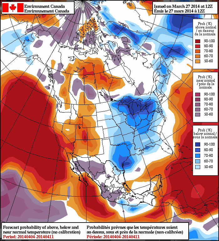
The NAEFS 8-14 day outlook is showing near-normal temperatures for Southern Manitoba.

Anything to melt the snow will be a welcome site to winter-weary Winnipeggers. As pointed out over by JJ over at his Winnipeg Weather blog, this December to March period will be the coldest one in 115 years with the next coldest being the winter of 1898-99. With last night’s low dropping below -20°C, Rob pointed out over at Rob’s Obs that it will mark the 15th time this month temperatures have dropped below -20°C; typically that only happens 5 times in March.[3]


  1. The 1872 to 2013 mean temperature – an average of both the highs and the lows – is 3.5°C.  ↩
  2. Instead of a very deep layer, like we would see in January or February.  ↩
  3. Apparently I’ve dropped the ball by waiting until March was <em>over</em> before calculating my March statistics!  ↩

Just enough time to mow the grass.

Enjoy the sun today and tomorrow because guess what, more rain is on the way.


June 3, 2011 Hand-Analysis of 12Z Sounding Data; Black lines are heights, coloured lines are θw values.

The broken record keeps on repeating in Winnipeg as rain gives way to sun gives way to rain with just enough time to mow the grass in between.  With the system that brought numerous damaging storms across Southern Manitoba yesterday moving out, the upper flow aligns itself to place the Southern Prairies directly along the main storm track.


Convective outlook for June 3, 2011.

Little significant weather is expected in Southern Manitoba today, with only the slight chance of a thundershower or two over the Parkland areas, mainly in the northern Minnedosa and Dauphin regions.  Sunny skies will prevail through the evening for areas in the Red River Valley and east before a few clouds move in overnight.  Get out there and enjoy the beautiful weather!


24hr. cumulative precipitation valid 12Z Sunday 5 June from the 12Z 3 June GEMREG; my personal opinion is that it drags the precipitation a little too far south across the Prairies and that the streak through Southern Manitoba will likely be further north.

Things change by tomorrow evening, though.  A new system currently moving into the Prairies from the Yukon Territory will arrive in the Southern Prairies by tomorrow afternoon and into the Red River Valley by tomorrow evening.  This system will produce a lengthy trail of precipitation, however it’s north-to-south width looks fairly narrow.  The exact position of this shortwave will determine where precisely the rain will fall, although all indications currently point to another 2-4mm of rain pushing through the Winnipeg/Gimli/Selkirk/Whiteshell areas with lesser amounts further south.

This precipitation looks to clear out by Monday morning, leaving behind general instability through the region due to an elongated surface trough hanging back from the main system.

The sun will then come out (hopefully) in full force Monday afternoon and Tuesday morning, before cloud moves back in on Tuesday afternoon ahead of yet another low pressure system.


12hr. cumulative precipitation valid 12Z Wed 8 June from the 12Z Fri 3 June GEM-GLB

This third system within a week will push in on Tuesday evening with a warm front positioned just south of the international border, draped west-to-east across North Daktoa.  Some light rain with the risk of elevated thunderstorms riding over the warm front with push into our area by Tuesday evening before developing into a large area of moderate rain overnight.  It looks to rain through Wednesday and most of Thursday night before tapering off on Thursday morning.

This system is still a ways off, so we’ll fire off another blog post in a couple days with some more details on that one.  We’ll update Sunday’s system right in the comments here.

Do you have any stories or pictures from the storms yesterday?  Feel free to leave them in the comments or fire a tweet off to our official Twitter account, @WeatherInThePeg.