Elsewhere in Weather News: November 29th, 2014

Widespread Floods Affect Southern France

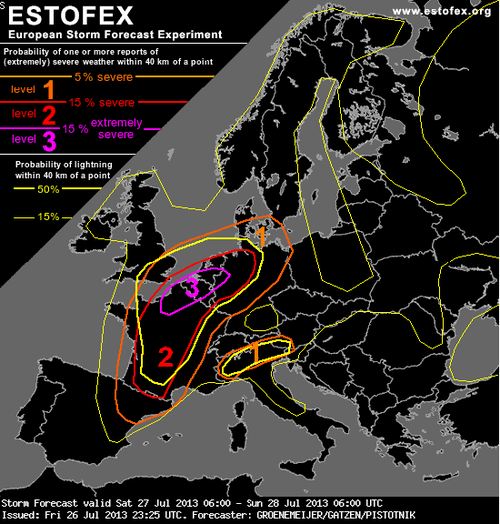
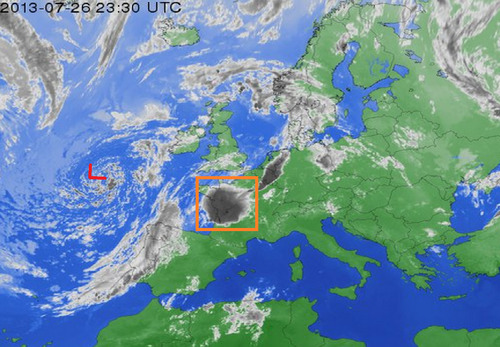
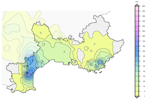
A low pressure system advecting plenty of moisture Poleward from the Mediterranean Sea was in place over south-central France on Monday making for a good setup of long lasting heavy rains. The rains, enhanced by scattered thunderstorms prompted Météo France to issue various warnings, from strong wind warnings to severe thunderstorm warnings in addition to the rainfall warnings. A few areas along France’s southern coast were particularly hard hit with rainfall totals between 180-210mm in six hours on Monday. In addition to that another general 40-50mm (some amounts higher locally) fell as the system was moving off on Tuesday. On Wednesday, another low pressure system quickly moved into the region, again bringing with it rain and more storms. There was also a report of a weak tornado accompanying the one of the storms.

With already saturated soils from earlier in the week, conditions were primed for overland flooding as the second system moved in. Helicopters and rescue workers were hard at work towards the end of this week as people got trapped in their vehicles and houses from the flooding in southeastern France. There were five deaths related to the flooding events and 6,000 households were without power. The damage from the unconfirmed tornado comprised of roofs blown off and trees uprooted.

Precipitation map (in millimeters) of the rainfall in Southern France on Monday only. (Source: Météo France)

Unfortunately the soggy weather is expected to stick around the region this weekend. The upper-level cutoff low located over Southern Spain will drift ever so slowly to the east but will bring with it more showers and rain to southern France.

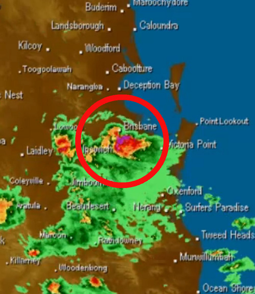
In other news, a supercell hit Brisbane, Australia this past week and knocked out power to 90,000 residents. The storm brought just about everything with it; golf ball size hail, strong winds and flash flooding – damages are in the hundreds of millions.

Radar image at the time the supercell was passing over Brisbane. (Source: BoM)

Elsewhere in Weather News: July 27th, 2013

France Faces Severe Storms; More Coming Today

France has had its fair share of severe storms this past week, with more of it expected to come today (Saturday). A level 3 “severe” thunderstorm, the highest risk possible, has been issued by ESTOFEX (European Storm Forecast Experiment) for the northern half of France. Conditions are favorable for tornadoes with a warm front draped across the region and incoming cold front from the west; an upper-level low spinning off the coast of France over the Atlantic will provide sufficient destabilization in the upper levels of the atmosphere.

ESTOFEX forecast

ESTOFEX forecast for today, risk 3 in northern France, Belgium, Netherlands and northwest Germany. Highest risk for large tornadoes resides here. (Source: ESTOFEX)

The only potential flaw in the setup could be due to the large MCS that fired up on Friday evening in west-central France as it continues to move northeast potentially leaving debris cloud in the region this morning. But with that said, as of Friday evening, the MCS was moving fairly quickly, and at this rate would be out of the region in time for tomorrow’s setup. With dewpoints in the low twenty Celsius range, shear plentiful with the approaching upper-level trough, and a great shear profile, all kinds of severe weather could be in play, including powerful tornadoes. The severe weather risk also extends into northwest Germany, Belgium and the Netherlands.

MCS and upper level low

Upper level low spinning off the coast of France and MCS in orange box that could hinder storm activity tomorrow. Infrared satellite image taken Friday evening. (Infrared satellite image source: Weather Online)

The expected severe weather follows a significant weather outbreak that occurred in France on Tuesday afternoon. Strong storms passed through the Burgundy region dropping large hail (between ping-pong and golf ball size) and causing significant damage to vineyards. In this region, crop losses are as much as 75% in the hardest hit areas. Flooding was also an issue, where some main roads such as the one between Pommard and Volnay were flooded out and impassable.

In 2008 an EF-4 tornado touched down around Hautmont, France and caused 4 fatalities and 18 injuries. Severe weather is not that common of an occurrence in France, with only a couple outbreaks per year.