Elsewhere in Weather News: August 10th, 2013

Potent Heatwave Strikes China; Possible Typhoon on the Way

A prolonged heatwave has been in place for this whole week and even a part of last week over most of Eastern China, including the megacity of Shanghai. An upper-level ridge centered directly over Shanghai (but covering the whole region) is contributing to abnormally high temperatures in the region. Scorching heat, ranging from the high thirties to low forties, covered the whole region while remaining in place yesterday. Numerous heat alerts were issued by the Chinese government urging residents to limit outdoor activities, spend time in air conditioned buildings and most importantly, to stay well hydrated. Unfortunately the death toll had risen to 10 people as of Friday, with Shanghai hardest hit.

China surface temperatures

Map of Eastern China’s surface temperatures for today at 4pm, dark orange is over 36 degrees Celcius. (Source: Wunderground maps)

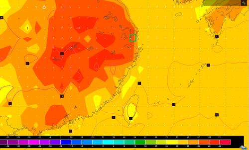
Such a potent heatwave in this region is not common – it has been said that this one is the worst in 140 years. On August 7th Shanghai broke its all-time record temperature, recording an official high of 40.8°C. Before the recent heatwave began, the highest temperature ever recorded in Shanghai was 40.2°C set in 1934. Shanghai’s average high temperature for August is 32°C. Drought concerns are now coming into play as water sources are starting to run low in the east-central region of China where little to no rainfall is expected in the coming week while the heatwave continues.

The southern coast of China could be under the gun for some drenching rains associated with an incoming typhoon: Typhoon Utor. Utor has still not passed over the Philippines but it is expected to make landfall to the northeast of Manila as a category two. Following its first landfall, it will continue travelling into the South China Sea though there is still a lot of uncertainty as to whether it will curve north into China’s mainland or simply brush the south coast.

Utor

Infrared satellite image of Utor on Friday evening, and it’s expected track. (Source: CIMSS)

Elsewhere in Weather News: July 20th, 2013

Severe Weather Outbreak in Southern Ontario; Numerous Warnings Issued Friday

On Friday, severe weather rolled across much of southern Ontario, southern Quebec and nearby states such as Michigan and New York. Severe weather was imminent in the region as a strong squall line of storms formed with some bowing segments in the morning and continued into a great thunderstorm environment as the afternoon wore on. CAPE values were quite high, shear sufficient and for any storms that remained discrete, a decent tornado potential was there before getting absorbed into the squall line. This prompted a plethora of warnings to be issued, including numerous tornado warnings throughout the day.

Wind damage was the biggest concern on Friday though, numerous reports of wind gusts exceeding 100km/h and even one report as high as 119km/h in Waterloo Ont., were reported. In turn, significant damage was reported across southern Ontario; mature trees knocked down, trees falling on homes and winds flattening crops. As of Friday night 550,000 people were still without power in Quebec and Ontario due to winds knocking down power lines and trees falling on lines. Storm survey teams are expected to head out to various spots across southern Ontario tomorrow to determine if damage was caused by straight-line winds or a tornado touching down. Two unconfirmed funnel clouds had been reported around the towns of Bradford and Barrie, Ontario. Unfortunately one person has died and ten more have been injured because of falling tree limbs; this is a reminder to people that even though a tornado might not be imminent, it’s better to take cover as a storm approaches.

Downed tree

Large trees downed in Toronto by strong winds produced in Friday’s storms. (Source: City News)

The cold front behind this system will put end to Ontario’s heatwave. Many cities in southern Ontario, including Toronto, had reached “official” heatwave status by reaching 32°C three days in a row. This combined with high humidity values made for excessive heat, therefore it’s likely that most residents will welcome the cooler and drier air on Sunday.

Elsewhere in Weather News: March 2nd, 2013

Strong Cyclone Affects Australia, Temperature Records Tallied

This past week a cyclone, Rusty, formed off the coast of north-western Australia and quickly spun into a strong cyclone by Australian standards. The cyclone made landfall as category one by Saffir Simpson Scale standards, (rated category 3 by Australian Bureau of Meterology) and even though it brought hurricane force winds, it affected an area of Australia that is sparsely populated. This meant that not much damage was caused by Rusty and only some overland flooding was reported as well as about a hundred houses without power. As Rusty moved inland, heavy rains and high wind gusts were the main concerns; over 450mm of rain fell and gusts of 150km/h were experienced around and south of the area where Rusty made landfall. Rusty’s quick strengthening off the north-western was aided by unusually warm waters – near 31°C and only about ten knots of shear present at the time.

Rusty Flooding

Flooding in an area just south of where Rusty made landfall. (Source: @Sturap)

This week the Australian Bureau of Meteorology also announced that the warmest summer on record (records since 1910) occurred this past summer. Australia’s average temperature surpassed the normal by 1.1°C and 95% of the country had above average temperatures this summer. Birdsville, Australia which typically has an average high temperature between 35°C and 38°C during summer had 31 consecutive days above 40°C. It has truly been an impressive summer 2012-2013 temperature-wise for Australia!

Average temperature anomalies

Average temperature anomalies for Australia summer 2012-2013. Much of Australia above average. (Souce: BoM)

In other news, another significant blizzard went through the Southern US Plains bringing more short-term drought relief to the area. Some areas in north-western Oklahoma and the Texas Panhandle received over 35cm of snow. Blizzard conditions were in place as strong winds and heavy snow fell along the deformation zone of the low pressure system. Almost all roads in the Texas Panhandle were impassable because of large snow drifts, residents were urged to stay home. Weather in the Southern Plains will be fairly calm this weekend and at the start of next week; no significant precipitation accumulation is expected.