Many areas in Southern and South-Eastern Manitoba dealt with the heaviest snowfall of the Winter 2011-2012 season. The powerful Colorado Low that impacted our region dumped up to 20cm of snow in some localities, however due to an extremly sharp deformation zone, many residents may have been asking themselves where the snow was.
Snow pushed into Southern Manitoba late in the afternoon from North Dakota as the main area of lift was advected northward and intensified by a developing low pressure area in Northern North Dakota. Forecasting the event was very tricky, as model guidance had little consensus, with some models painting a swath of 10-20cm of snow over the entire RRV and others keeping all snow in Minnesota and Northwestern Ontario. This situation wasn’t unexpected, though; models often have difficulty dealing with the huge energy transfer that occurs in Colorado Lows.
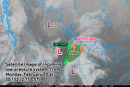
Heavy snow pushed into Southeastern Mantioba early in the evening with snowfall accumulation rates of 2-3cm per hour. As the system developed, it became more and more clear where exactly the snow was going to fall. What was surprising, though, was how exact one could be in their snowfall forecasts.
The areas that would recieve snowfall were completely dominated by what is known as the deformation zone. This is an upper-atomspheric feature that every low pressure system has; the clearest way to describe it is that it’s the feature created by a large area of air moving in one direction that is then split in two, with one stream heading 90° to the left and one stream heading 90° to the right.
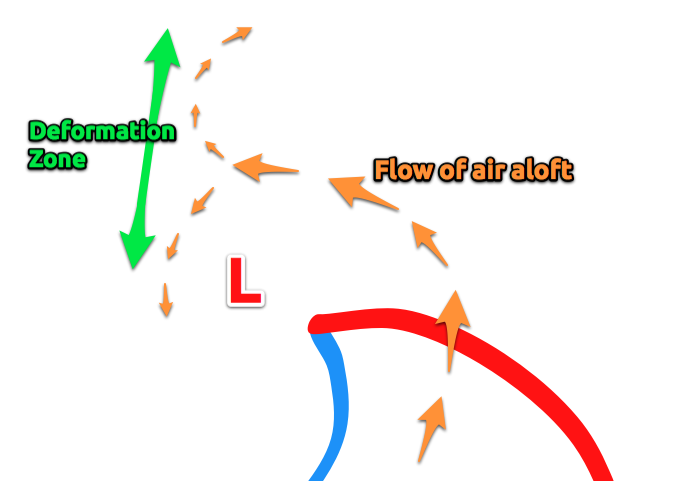
This feature often can be used to help forecast preicpitation because as air carries precipitation towards it, it is deflected in either direction and cannot push past that line. The strength of deformation zone varies, and how far past it the precipitation can penetrate is related to how strong the deformation zone is.
As the snow pushed into Southern Manitoba, it quickly became apparent that there was going to be a sharp line for where heavy snowfall occured. The following RADAR image shows how significant the deformation zone was:
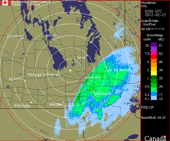
Typically precipitation will diminish over 50-100km across a deformation zone; on Monday night we were looking at distances of 10-20km dramatically altering how much snow any one location would recieve.
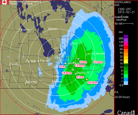
So! How much snow fell? It depends where you are. Snowfall totals:
| Location | Total Snowfall |
Winnipeg – St. Bonifice | 6.25cm |
|---|---|
| Winnipeg – Airport | 2.0cm |
| Winnipeg – Charleswood | 3.8cm |
| Winnipeg – Downtown | 3.0cm |
| Winnipeg – East | 9.1cm |
| Winnipeg – River Park South | 8.5cm |
| Beausejour | 15.0cm |
| Landmark | 14.0cm |
| Indian Bay | 17.0cm |
| Oakbank | 13.4cm |
| Pinawa | 15.4cm |
| Steinbach | 21.0cm |
| Woodridge | 20.0cm |
As the RADAR accumulations show, most areas within 15-20km of Highway 75 recieved 5-10cm of snow, and amounts dramatically decreased as you headed east, with essentially no snow in Morden. Even across the City of Winnipeg, snowfall amounts varied by almost 10cm.
The storm had far-reaching effects. Heavy snow on power lines knocked out power to much of Falcon Lake as well as parts of Sprague and St. Adolphe. 16 schools/divisions in SE Manitoba were closed today as a result of the snowfall. The storm left many roads in eastern Winnipeg as well as most highways south and east of the city slippery and snow-covered; icy conditions are suspected to be responsible for one fatal collision this morning on Lagimodier Blvd.
This snowfall was easily the largest one of the season, and was the largest single snowfall in Steinbach since the winter of 2009. If you were hoping for an early spring with a snow-free end to February…well, you may have to wait a little bit longer. The extensive snow cover will limit any typical warming we would get with southerly winds over the next while. The silver lining? The distinct lack of snowfall over the Western Red River Valley would allow warmer (above 0°C) temperatures to push into the Central and Eastern RRV if we were to be under a good westerly flow. We’ll have to shovel out and wait a bit for that, though…


