Elsewhere in Weather News: September 21st, 2013

Super Typhoon Usagi Takes Aim at Hong Kong

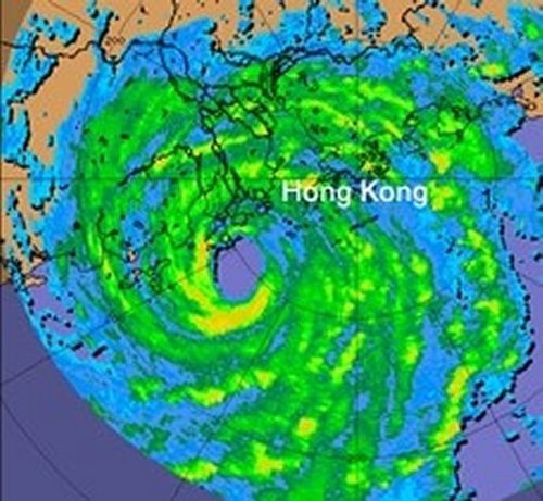
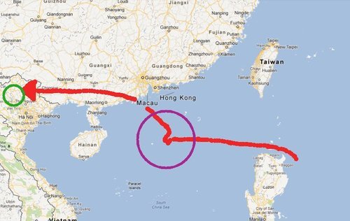
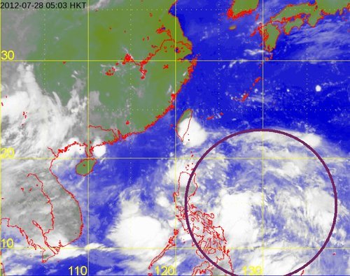
The strongest typhoon of the year up to date has formed in the Pacific and is taking aim at Hong Kong. Super typhoon Usagi is currently located in the Luzon Strait between Taiwan and the Philippines and is moving in a west north-westerly fashion. Thursday and Friday morning, Usagi was packing sustained winds of around 260km/h – considered category five strength. It has since slightly weakened but is still a dangerous category four super typhoon as it eyes (no pun intended) Hong Kong and the southern coast of China.

Usagi

Awesome image of Usagi Thursday afternoon. (Source: Colorado State University/Capital Weather)

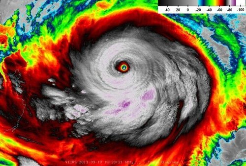
This super typhoon is not only a very powerful typhoon but also a very large one; its diameter reaching over 1,000km. A very distinct eye could be seen on satellite as well as more than one eyewall present; it is not as common for a tropical system to have more than one eyewall, though it does happen with storms of category three or higher.

Usagi is expected to make landfall sometime on Sunday along the south China shores. Its impacts remain to be seen though, with seas expected reaching 10 meters in the South China Sea all vessels will have to steer clear or dock. Another concern is the rainfall; already copious amounts of rain have fallen in Taiwan, especially on its east coast where about a meter of rain was not out of the question before the weekend’s end.

In addition to Usagi, a second typhoon is expected to form this weekend behind (to the east) of Usagi, it will be named Pabuk. Although still a ways out, Pabuk has a good chance at becoming a severe typhoon due to the warm sea surface temperatures and low shear in the area. Currently, the models show Pabuk reaching the eastern shores of Japan but then quickly curving back out to sea – this would suggest minimal impacts to Japan.

Elsewhere in Weather News: April 27th, 2013

Fairly Calm Week

It has been relatively quiet weather-wise across the globe this week with no significant events affecting heavily populated areas. However, there were still some extreme weather events that took place, although more localized.

This past Thursday, a cold front pushing south across Hong Kong and parts of south-east China dropped excessive amounts of rainfall, triggering flood concerns. The front had significant warm and moist air to work with as it slowly moved south towards the South China Sea. Several reports came in from south-eastern China showing 50mm of rain in a 24 hour period, concerning residents of increased flood risk this weekend and into next week thanks to another low pressure through making its way into the region.

In other news, isolated severe storms pushed through the state of Louisiana Wednesday. The long cold front extended from Southern Ontario all the way down to Louisiana; where dynamics were most favorable for severe storms midday Wednesday. A weak tornado even touched down in Keeling, a suburb of New Orleans, causing power outages and downing trees. After the storms moved through, 32,000 people in the area were left without power, but it has since been restored. There is a chance for more severe weather in the same area on Sunday and severe weather in the Plains region early next week. Following those events, there isn’t any indication of severe weather until at least next weekend as moisture gets flushed out. What comes after that remains to be seen as there is much uncertainty between weather models.

Dewpoints

Surface dewpoints (in Fahrenheit) Wednesday morning. Cold front is clearly visible and the circled area ahead of the front in Louisiana had the highest tornado potential. (Source: Twisterdata)

Elsewhere in Weather News: July 28th, 2012

Severe Typhoon Vicente Plows through Southern Asia

This past week, typhoon Vicente spun up in the Pacific Ocean and made landfall near Hong Kong on July 23rd. The severe typhoon, of category 2 hurricane strength, amassed winds of between 155km/h just before it made landfall about 100 kilometres to the south-west of Hong Kong’s city core. Although the typhoon first touched land outside of Hong Kong, its hurricane-force winds did extend out into the city. In consequence, the Hong Kong Observatory (HKO) issued a level 10 advisory – the highest possible on the scale – advising residents to stay inside and closing non-essential services as well as schools. The level 10 advisory had only occurred 13 times since 1946, with this most recent advisory being the first in the 21st century (the last level 10 advisory was issued in 1999). Vicente had somewhat of an unusual track, being stationary 300 kilometres to the south of Hong Kong for 15 hours then strengthening significantly before moving inland the following day. The strengthening that occurred with Vicente, within this short amount of time (48h), had never been observed this close to land with prior significant typhoons that struck the region.

Vicente

RADAR image of Vicente as he made landfall on the afternoon of July 23rd. (Source: HKO)

Although Vicente forced the HKO to issue a level 10 advisory, damage was fairly minimal in the city – only minor damage to buildings was reported, but no structural damage. Flights in and out of Hong Kong were either cancelled or delayed which did cause some grief to travellers in the region.

Vicente did not stop its tracks in Hong Kong. It continued westward towards Southern China and Northern Vietnam where it dumped large amounts of rain during its passage. This in turn caused landslides and flooding in the mountainous region of Northern Vietnam, killing seven people with three still missing. The Vietnamese government has sent out rescue teams to look for the residents still missing. Damage is quite significant in the region, with most houses and crops destroyed due to the flash flooding and landslides.

Vicente Track

Red line depicting Vicente’s track, green circle are the areas of Vietnam affected by the flooding and purple circle is the area where Vicente intensified quickly. (Map credit: Google Maps)

Another tropical depression appears to be forming to the east of the Philippines with some thunderstorm activity, which is something to keep an eye on in the coming week!

Tropical disturbance

The tropical disturbance east of the Philippines. (Source: HKO)