Elsewhere in Weather News: September 7th, 2012

Tropical Storm Leslie a Threat to Canada

With the hurricane season nearing its peak in the Atlantic, more tropical systems have spun up this past week. The first system which is not much of a concern (unless you are boating in the middle of the Atlantic) is Michael. Michael, once a category three hurricane, the strongest seen this year, has been spinning in the middle of the North Atlantic for a while now and is not expected to make a landfall.

Leslie

Leslie still not organized very efficiently with a broad circulation on IR satellite as of Friday evening. (Source: Wunderground/NASA)

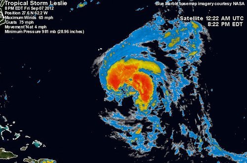
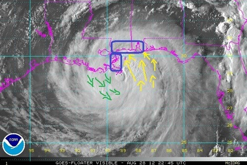
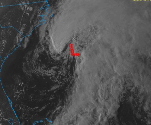
The second storm; Leslie, however, is spinning west of Michael and has a small chance at making a landfall somewhere on the south-eastern coast of Newfoundland, Canada. Bermuda is already experiencing high surf and there’s a good chance they’ll experience tropical storm force winds this Sunday since Leslie is such a large storm. By that time, Leslie will likely be upgraded to hurricane status of category one. It will slowly start moving north as the trough moving in from Eastern Canada approaches the storm. Though, with that said, Leslie still stands a slim chance at making landfall on Canadian soil and making a significant impact on the province. Since this possibility is still quite a ways away – five to six days – weather models are having trouble deciphering Leslie’s exact future track.

Leslie tracks

Model consensus appears to be leaning towards no landfall and more of a rain event for Newfoundland. (Source: SFWMD)

Even though Leslie might come close to Newfoundland within the next week or so, it appears the worst part of the storm will be well off to the east of the island as the top right quadrant of the storm where the strongest winds are located is not expected to affect land. The last time Newfoundland got struck by a tropical disturbance was back in October of last year where tropical storm Ophelia struck, dumping heavy rains on the Avalon Peninsula of Newfoundland. The most memorable hurricane to affect Newfoundland in recent memory had to have been Hurricane Igor, in 2008. This hurricane caused severe flooding to the eastern half of Newfoundland where in St. Lawrence, NFLD, 238mm fell. This was the most damaging hurricane to have ever hit Newfoundland in recent history.

Updates on Leslie will be forthcoming as it nears Canada!

Elsewhere in Weather News: September 1st, 2012

Tropical Depression Isaac: Update

What was once dubbed Hurricane Isaac when it made landfall as a category one hurricane, is now considered a ‘tropical depression’. Isaac continues to pose a threat a week after it made landfall but it has weakened significantly, and will continue to do so, as it penetrates further into the southern half of Continental United States. Although this hurricane was “only” rated a category one when it made landfall, comprising of maximum sustained winds of 135km/h at peak intensity, you would have not guessed the incredible amounts of rain it brought into Louisiana and surrounding Gulf States. Here are a couple of the most impressive rainfall totals recorded throughout the whole event:

-In Gretna, LA, the National Hurricane Center (NHC) unofficially reported 466mm of rainfall.
-In New Orleans, LA, 510mm of rainfall was reported, breaking New Orleans’ old daily rainfall record by 48mm (a record thsat was set by Hurricane Katrina).
-In Kiln, MS (west of Gulfport) 433mm of rainfall was reported.

Not only did Hurricane Isaac bring with it enormous amounts of rain, the storm surge that accompanied it was quite severe. Wind-driven storm surge is mostly caused by the severe winds accompanying a hurricane. These winds push ocean waters towards land similar to a wave but larger in size (in this case with south winds) and in turn, ocean levels are higher than the normal tide. This phenomena makes for serious flooding along the Gulf Coast since the terrain along the Gulf of Mexico is not mountainuous – it is more of a gradual slope. When ocean water then rises, it is easy for it to move inland quickly.

Isaac storm surge

Hurricane Isaac’s wind direction depicted with arrows. Blue boxes along the shoreline show areas where winds were favorable for storm surge. Green arrows (north winds) is where storm surge was less favorable because of the wind direction. Picture was taken just before landfall on the night of August 28th. (Source: NOAA)

In Louisiana, two people lost their lives in the Plaquemines Parish, one of the hardest hit parishes, as the tide rolled in and consumed their house. This now brings the Hurricane Isaac death toll in the United States to four, with damages listed in the hundreds of millions. In Louisiana and Mississippi, power was out to over a million people and it was estimated that 75% of New Orleans was out of power when the eye wall passed closest to the city. For a storm being of weak category one, it did an extensive amount of damage. This was in part caused by it’s broad area of precipitation, large area extending out from the eye of tropical storm force winds, extremely slow movement, and storm surge levels you would expect form a category two or three hurricane.

Flooding

Residents evacuating in Lafitte, LA by boat because of flooding. (Source: Yahoo News)

This week in the tropics there are three other notable storms: Hurricane Kirk out in the middle of the Atlantic which poses no threat to land; Tropical Storm Leslie which does not pose a threat to the United States but as it strengthens, could pose a threat to Bremuda; and lastly, Hurricane Ileana out in the Eastern Pacific poses no threat to land but could cause high surf to the Baja Peninsula.

Elsewhere in Weather News: August 4th, 2012

Another Typhoon Churns in the Pacific

Yet another typhoon, Saola, has made landfall in the Western Pacific this past week, this time hitting Taiwan hard. The “disturbed area” talked about in last week’s EIWN is the culprit for producing typhoon Saola, which made landfall Wednesday, August 1st (Thursday August 2nd Taiwan time), bore winds of around 155km/h. The capital city of Taipei was completely shut down because of this typhoon: financial markets were closed, all businesses were closed, and residents urged to stay inside.

Saola

Typhoon Saola just as the strongest part of the storm made landfall on Taiwan (taken August 1, 2:32pm). (Source: NEXSAT Satellite)

Saola swamped streets and downed large trees as it passed over Taiwan, not to mention the enormous amounts of rain it dumped. Since Tuesday, some areas of Taiwan have received more than 1,000mm of rainfall – that’s about double our yearly amounts here in Winnipeg! The death toll from the extreme flooding Saola caused has reached 27, mostly Taiwan and Philippine residents. The flood waters are still receding and in turn more casualties may be discovered. Taiwan has deployed 48,000 soldiers to the area to help with the cleanup of Taipei and surrounding regions, and rescue teams are also currently hard at work. The typhoon has disrupted flights going in and out of Taiwan and caused chaos in the railway industry.

Flooding

Snapshot of the flooding Saola caused in Taiwan. (Source: AFP)

Unfortunately, typhoons don’t seem to be letting up in this already battered region of the Pacific where yet another typhoon has spawned east of China and will make landfall somewhere north of Shanghai. Saola will continue west and is predicted to make a second landfall west of Taiwan on China’s south-east coast on Friday (Winnipeg time).

Typhoons

The tracks of typhoon Saola/Damray as of Thursday evening. (Source: HKO)

In other hurricane-related news (Atlantic basin), a tropical storm, Ernesto, has spawned in the Atlantic eyeing to the Carribean where it will dump massive amounts of rain on the Lesser Antillies. Early Thursday morning a 101km/h gust was recorded at St Lucia where a tropical storm warning has been issued for the Lesser Antillies and residents have bunkered down. Ernesto is expected to make a north northwesterly track and most models show it ending up in the southern Gulf of Mexico by early next week. However, that is still a ways away and hurricanes can sometimes make unpredictable turns, in consequence, a constant eye needs to be kept on the most current satellite and model data.

Elsewhere in Weather News: May 26th, 2012

Already an Active 2012 Hurricane Season

The first major hurricane of the year for the Eastern Pacific Ocean spun up on May 22 to the south-west of Mexico and will likely make landfall on the west coast. As of Friday afternoon, Hurricane Bud was cruising along at a northerly trajectory as a category one hurricane, packing winds of 120km/h in its core and releasing very heavy rains within its spiral banding.

Hurricane Bud Friday afternoon

Infrared satellite picture of Bud near Mexico’s coast on Friday afternoon. (Source: NOAA)

Bud is forecast to decrease slightly in intensity as it hits the mountainous regions of Mexico’s west coast and interacts with the dry air to its north. However, Bud is still predicted to bring winds from 90km/h to 110km/h, as it makes landfall just to the south-west of Puerto Vallarta, between a weak category one hurricane and strong tropical storm status.

Bud's track

Bud’s track and coastal warnings; in blue a hurricane warning, in red a tropical storm warning, in pink a tropical storm watch. (Source: HEWS/NHC)

The worrisome part of this storm, however, is not the winds that accompany Bud, but the rainfall associated with it. From 150mm to 200mm are expected to fall with even higher amounts locally along the coast. As it makes landfall on the hilly coast, mudslides are a big threat to towns in the vicinity. A hurricane warning has been issued for a small part of the Mexican coast that is sparsely populated in the area where Bud’s centre will make landfall.

Interesting facts on Bud:

  • Bud is the strongest hurricane ever recorded in the Eastern Pacific this early in the year; it reached category three (185km/h) late Thursday night.
  • Only 12 hurricanes have been recorded in the Eastern Pacific in May since 1949, Bud is one of them.
  • Two meter high waves were already experienced on the Mexican coast Friday afternoon ahead of Bud.

Mexico officials say they are ready for Bud; they have cancelled schools in 11 municipalities for Friday and have 15,000 spots ready in rescue shelters if evacuations are needed. Bud will reach land on Friday night and slowly curve back out to the Pacific as a tropical depression by the end of the weekend.

The hurricane season in the Eastern Pacific officially started May 15th and it has already been very eventful at its outset with two named storms. In the Atlantic, where the season officially kicks off on June 1st, an area of low pressure is already forming off the coast of Georgia and has a very good shot of becoming a subtropical/tropical storm by this weekend. So, lots to keep an eye on during this active start to this year’s hurricane season as there will certainly be more to come!

Low off the east coast

Possible tropical storm forming off the east coast in infrared satellite. (Source: NOAA)