Cold Weather Ahead

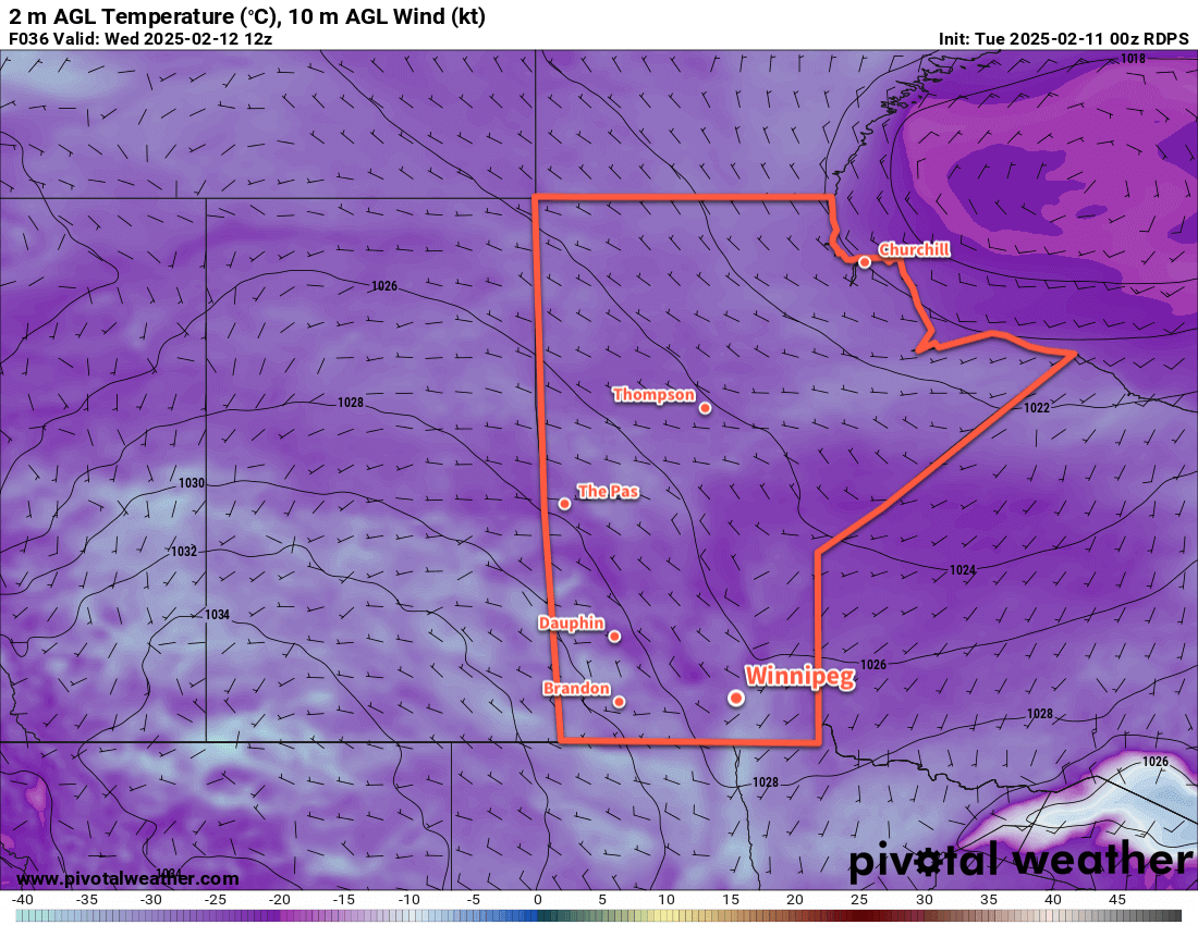
An Arctic ridge strengthening over southern Manitoba will bring bitterly cold weather to the region.

RDPS 2m Temperature Forecast valid 12Z Sunday February 16, 2025
Bitter cold will build into the Prairies this weekend.

The weather this weekend in the Winnipeg area will be influenced by three different weather systems. The first is an Arctic ridge re-strengthening across southern Manitoba, the second is a disturbance that will track across the northern United States, and the third is a low that will drop south out of Nunavut.

The Arctic ridge will bring colder weather to the Winnipeg area. Daytime highs will drop from the -20 to -15 °C range today into the -25 to -20 °C range this weekend. Likewise, overnight lows will dip from the -30 to -25 °C range down into the -35 to -30 °C range. These colder temperatures will combine with winds of 10 to 25 km/h and give wind chill values of -45 to -40 at times.

The other two features will bring cloud cover to the region. The disturbance passing to the south will bring mixed skies to the region today and on Saturday. Skies will clear on Saturday night, then mixed skies will redevelop on Sunday as the Nunavut low drops south.

A few flurries are possible on Sunday as the low passes through, but no accumulating snow is expected.

Long Range Outlook

Next week will bring a major change to the weather pattern in the region, but it will be in the latter half of the week. Temperatures will gradually shift to seasonal values through the first half of the week as the Arctic high in the region slowly drops south into the United States. In the second half of the week, the Polar Vortex will re-focus over the High Arctic while a lobe drops south into the United States. This will allow upper ridging to build east into the Prairies and send Pacific air back into the region.

This will allow temperatures to begin pushing back towards seasonal values by the end of the week, followed by the chance for daytime highs that climb above 0 °C on the weekend.

The above-normal temperature pattern looks like it should hold through the rest of February once it gets established. This may put Winnipeg back on the storm track and give a chance of mixed wintery precipitation from time to time.

The return of warmer weather and longer days will help it feel a lot more spring-like by next weekend!

Today’s seasonal daytime high in Winnipeg is -8 °C while the seasonal overnight low is -18 °C.

Cold Week Ahead for Winnipeg

With Arctic air firmly entrenched over the Prairies, the weather will be relatively quiet and cold for Winnipeg.

RDPS 2m Temperature Forecast valid 12Z Wednesday February 12, 2025
Very cold Arctic air with temperatures as low as the -30s will sit over the Prairies this week.

The forecast for this week will be a pretty straightforward one; little change is expected across the region through the work week. Arctic air will remain in place over the area, bringing cool daytime highs generally near -20 °C — perhaps a degree or two warmer at times — and overnight lows dipping down into the low -20s or the -30s. Wind chill values of -30 to -40 will be common through the week, with the change that some nights will bring wind chill values of -45 to -40, which would qualify for extreme cold warnings from the Meteorological Service of Canada.

The wind will be light out of the south at 10 to 20 km/h today, then shift to light and variable on Wednesday as a weak trough of low pressure moves through the region. It will exit later Wednesday and bring light northwest winds back to the area. Winds will then shift to the south and pick up into the 10 to 20 km/h range on Thursday as a surface high passes to the south and a weak low pushes towards western Manitoba.

Little weather will impact the region this week. The Winnipeg area will see sunny skies today, followed by some cloud cover on Wednesday as the trough moves through. Skies should clear up Wednesday night bringing sunshine back to the region for much of Thursday. Some cloud may begin to push in late in the day as that low pressure system nudges into the province.

When there is cloud cover, there’s a chance that the region could see some light snow or ice crystals; no notable accumulating snow is expected this week though.

Long Range Outlook

Heading into the weekend, another Arctic high will gradually shift across the Prairies. This will bring northwest to westerly winds with clearing skies. Temperatures will stay cold with similar temperatures through the weekend as seen during the week.

So it’s cold and quiet weather ahead. Fortunately it’s not as intense a deep-freeze as sometimes…I’ll take highs near -20 °C over those ruthless cold snaps where we barely reach -27 °C. That said, the nights will be cold and there will be little relief likely until the last week of February. Stay warm!

Today’s seasonal daytime high in Winnipeg is -9 °C while the seasonal overnight low is -19 °C.

Conditions Settling as Colder Temperatures Build In

Skies will gradually clear this weekend in Winnipeg as the Polar Vortex slumps towards the region.

RDPS 2m Temperature Forecast valid 21Z Sunday February 9, 2025
Temperatures will cool this weekend, but even colder weather will be pushing into the Prairies by the end of the weekend.

A weak disturbance dropping through the region will bring mixed skies to the Winnipeg area today. Temperatures will be similar to yesterday with a high in the -10 to -15 °C range, but winds will be much lighter at only around 15 to 20 km/h.

Skies will clear out a bit tonight, but a disturbance moving through the United States will spread a bit more cloud into southern Manitoba overnight into Saturday. Temperatures will dip down into the -25 to -20 °C range overnight with light winds.

On Saturday, Winnipeg will again see mixed skies with some morning cloud breaking up into the afternoon. Temperatures will be cooler with highs dipping to the -20 to -15 °C range with light winds.

By Saturday evening, the next big pattern shift for the region will be underway. An axis of colder air will begin building into the Prairies as the Polar Vortex begins to slowly drop southwards through the Arctic. This will entrench this first temperature drop into the region through the rest of the weekend.

Lows will dip into the -30 to 25 °C range on Saturday night with mainly clear skies and light winds.

On Sunday, a weak disturbance slumping through along the leading edge of colder air will slide through the region. It will bring mixed to cloudy skies with a chance of flurries to the region. For the Winnipeg area, a bit of snow will be most likely in the afternoon, while it will be earlier to the north and west. Daytime highs will climb back into the -20 to -15 °C range.

Some clouds will linger on Sunday night ad temperatures dip into the mid-minus 20s.

Long Range Outlook

Next week will be dominated by a single weather feature: the Polar Vortex. It will continue to drop southwards and build into the Prairies, bringing cold weather to the entire region.

Daytime highs will drop below -20 °C early next week with lows dipping close to -30 °C. There will be little change in the following 10 days. Daytime highs will largely sit in the -20s, save for the occasional passing disturbance that brings highs into the low minus teens. Overnight lows will dip into the low -20s or -30s many times right into mid-February.

It will be a prolonged stretch of cold weather that shows little sign of breaking down until late in the month. Extreme cold warnings will likely be issued by the weather office at times next week for the region.

We hope you all have a great weekend and we’ll see you back here in the deep freeze next week!

Today’s seasonal daytime high in Winnipeg is -10 °C while the seasonal overnight low is -20 °C.

#awm/below_seasonal_temperatures #Winnipeg #MBwx

Warming up in Winnipeg, but Colder Temperatures Lurk Nearby

Temperatures are warming up in Winnipeg, but a battle between warm and cold air is setting up over the province.

RDPS 2m Temperature Forecast valid 06Z Saturday January 25, 2025
A cold front will sweep through southern Manitoba on Friday night, bringing gusty northwest winds and some blowing snow.

To end the work week, a warm front will push through the Winnipeg area this morning. This front will bring a couple centimetres of light snow and moderate southerly winds as it pushes through. The snow will ease midday behind the front with winds shifting to the west. Temperatures will climb to a high near -2 °C this afternoon.

More snow will move into the region this evening, driven by a cold front following the warm front through the province. Another couple centimetres of snow will fall along with northwest winds up to 40 gusting 60 km/h. These winds will send temperatures back down into the mid-minus teens tonight and bring some blowing snow to the region.

Saturday will bring cooler, near-seasonal temperatures back to the region with a high just under -10 °C. Northwest winds will continue through the day at around 30 gusting 50 km/h, then ease off in the evening. A few flurries will be possible in the morning, then skies will clear. Another warm front will push into the region overnight, warming temperatures from a low in the mid-minus teens up to around -10 °C by Sunday morning.

On Sunday, a southwesterly breeze will bring mixed skies as temperatures climb into the -5 to 0 °C range. Temperatures will continue to warm towards the freezing mark on Sunday night as westerly winds of 20 to 30 km/h continue.

Long Range Outlook

Heading into next week, long-range forecasts show mild conditions for Winnipeg with daytime highs regularly near the freezing mark. There’s some uncertainty, though, as to whether the warmth will be able to stay in place over the region.

RDPS 2m Temperature Forecast valid 21Z Monday January 27, 2025
A sharp temperature gradient will set up over Manitoba next week, with above-freezing highs and the south and Arctic cold in the north.

The Polar Vortex is forecast to dip southeast into eastern Canada, and a strong temperature gradient will likely set up across Manitoba as a result. Daytime highs could reach above freezing over parts of southern Manitoba while temperatures into the -20s and -30s will be possible over northern Manitoba. With such a strong temperature gradient in place over the province, minor changes in front location could result in large swings in expected temperatures.

It will likely be a mild week next week, but minor features could also result in brief outbreaks of rather cold temperatures later in the week.

Today’s seasonal daytime high in Winnipeg is -12 °C while the seasonal overnight low is -23 °C.