Alberta Clipper to Bring More Snow This Week

An Alberta Clipper will bring more snow to Southern Manitoba this week. The system will also bring moderating temperatures, followed by another arctic blast.

Map of Tuesday's Alberta Clipper System - NAM Model

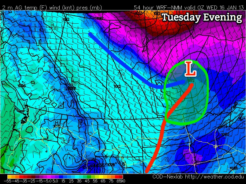
Before the Clipper arrives on Tuesday, we’ll see cold weather again on Monday. High temperatures on Monday will be in the high minus teens with light winds. A southerly flow will begin to develop over Manitoba on Monday night ahead of the next low pressure system. The south wind will become quite strong during the day on Tuesday, with wind speeds of 30-40km/h gusting to 50-60km/h in most areas (except in the Red River Valley where speeds may be a bit higher than that). These strong south winds will bring in much warmer air, with highs on Tuesday likely to be in the low to mid minus single digits in most areas. The Alberta Clipper is expected to begin spreading snow into Southern Manitoba on Tuesday afternoon. Areas in western Manitoba can generally expect 2-4cm of snow, with lower amounts the further south you go. In eastern Manitoba the highest amounts are expected, with total accumulation of 4 to 8cm expected (with higher amounts the further north you go). In the Red River Valley generally 2-5cm is expected, with Winnipeg and Selkirk having the best chance at higher end amounts. As the clipper moves past on Tuesday night, north-westerly winds will develop. These winds will be fairly strong, with readings of 40km/h gusting to 60km/h expected. This will generate blowing and drifting snow in open areas on Tuesday night. Blizzard conditions are not expected, but poor road conditions are still probable.

Models are suggesting that we may see another weaker Alberta Clipper pass by on Wednesday. At this point it’s too early to say exactly how much snow it will produce, but it has the potential to produce amounts similar to those experienced on Tuesday.

Beyond Wednesday it’s hard to tell what will happen next. It appears that Southern Manitoba will be right near the boundary between very cold arctic air to the north and somewhat milder air to the south. If this boundary ends up a bit further south than expected we’ll be firmly placed in that arctic air mass, but if the boundary is further north than expected we may get into the milder air. More weak Alberta Clipper systems are forecast to ride along this arctic boundary, so our position near it suggests we may see more light snowfall events later this week.

A Seasonal Start To The Week

Seasonal temperatures will be in place for Winnipeg & the Red River Valley for the start of the week as a continued weak southerly flow keeps the Arctic air locked up to our north.

The CMHR on a Snowy Winnipeg Morning

The Canadian Museum for Human Rights on a snowy Winnipeg morning.

Temperatures will sit near -10°C today through Winnipeg & the RRV, perhaps climbing up to -9 or -8°C briefly. We’ll see light snow through much of the morning with a chance for it to redevelop this evening for a few hours. Accumulations will sit around 2-4cm from this very light, fluffy snow, but it will likely have significant impact on roadways. Combined with the warmer temperatures, fog, and patchy freezing drizzle, some roads in Winnipeg and some provincial highways are already quite icy. As this light, fluffy snow is driven on, it tends to compact to a thin layer of ice; this will likely make it so that some highways, including the Perimeter Highway, side-streets and intersections are quite slippery by the evening commute. Be sure to leave yourself some extra time if you need to drive this evening.

Temperatures will remain fairly steady tonight or even climb a degree or two and another push of warmer air moves in. Once again we’ll likely see dense fog patches and patchy freezing drizzle redevelop tonight as this warm air advances towards the RRV.

Tomorrow, temperatures will climb to about -5°C with scattered flurries through the RRV. Winds will remain light, so it will be another great day to get outside. Some light snow will move through Winnipeg & the RRV tomorrow evening/night as a weak disturbance passes to our south. We’ll get another 1-2cm of snow as temperatures drop back towards -10°C.

Wednesday looks to be almost a carbon copy of today, with some light snow and highs around -9°C. The rest of the week is a little more uncertain; models all hint that the upper-level flow pattern will begin to break down, but how quickly that will happen is uncertain still. While the next few days will almost certainly be cloudy, we’ll probably see the sun start to make an appearance later in the week, if not having the clouds completely clear out. We’ll have more details on the second half of the week on Wednesday.

Mild Weather To Bring Cloudy Skies…Again

A southwest flow aloft is bringing warmer air back to the Prairie provinces, however with plenty of snow around to melt, our sunshine won’t last long…

A shot of sunshine in Winnipeg; a rather elusive feat as of late. The sun will go back into hiding this weekend. Photo credit: Instagram user @shwaahall.

We’ll see mainly sunny skies today as temperatures climb to right around the 0°C mark with winds out of the south at 30km/h. As winds subside this evening after sunset, stratus clouds and fog will begin to develop in the Red River Valley as all the moisture from melting snowpack is stuck underneath the inversion and is forced to condense as the temperatures drop. Expect an overnight low of –5°C tonight. The fog patches will stick around the RRV into Saturday morning before lifting.

Clouds will stick around for the day on Saturday as temperatures climb to about –1°C. Fog patches will likely redevelop on Saturday night as temperatures dip down to –5°C again. Sunday looks to be a mainly cloudy day as well, with a daytime high once again right near the freezing mark.

For now it looks like we may see the cloud get scoured out of the Valley as a surface trough moves through on Monday; for now, enjoy the sunshine today…we likely won’t see it for another couple days.