Fall Weather

Fall has officially begun and, rather fittingly, fall weather is in store for the next few days.

High pressure will be in place over much of Manitoba for the first part of the week

High pressure will be in place over Manitoba for the first part of the week

Temperatures for the first few days of this week are expected to be around or slightly below normal. Monday, Tuesday, and Wednesday will all have high temperatures in the low to mid teens (normal high is 16C). Monday will have a cool north wind, but on Tuesday and Wednesday the wind should not be much of a factor. No notable precipitation is expected for the first half of this week as we remain under a surface ridge of high pressure.

Models have been hinting at some warmer weather towards the end of this week into next weekend. As the high pressure system from earlier in the week moves off to the east it appears that a southerly flow will develop over Southern Manitoba, allowing us to see some more above-normal weather before the end of the month.

Frosty to Start the Week

We’ll be in for a couple of chilly, perhaps you could even say frosty, days to start this week. Cool daytime highs and sub-zero nighttime lows are on tap.

GEM-REG 3hr. Precipitation Accumulation

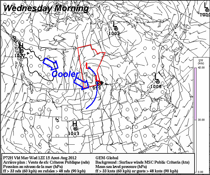
Some light lake effect showers (shown in blue) are expected to develop on Monday as cold air flows over the relatively warm lakes winnipeg and manitoba.

After a rather chilly Monday morning, temperatures won’t make a dramatic recovery for the afternoon. Daytime highs on the first day of the week are expected to barely make the double digits in most areas, with highs generally in the 9-12C range expected. A breezy north wind and perhaps a couple of lake-effect showers won’t make the day any more pleasant. Tuesday night should be another cool one in Southern Manitoba. However, it appears frost will be isolated to areas around and east of the Red River Valley as some warmer air moving in from the west will keep temperatures above zero overnight in Western Manitoba. Daytime highs on Tuesday will be an improvement from Monday, though except for South-Western Manitoba where 20C values are expected, temperatures will generally remain stuck in the mid teens.

Yet another cold front will swing through overnight Tuesday into Wednesday ushering in another cool airmass to end the week. It appears high temperatures will be relegated to the teens from Wednesday through Friday. There appears to be slim odds of any significant precipitation this week, though we may at least get some measureable rain later in the week as a few strong impulses rotate through the region.

NAEFS Ensemble 8-14 day outlook

The NAEFS ensemble doesn’t give a strong indication of what type of weather we’ll see moving forward…

At this point the long range forecast looks fairly status quo. We’ll see some cooler than normal days and some warmer than normal days, but in general the pattern for the next week or two generally looks to be near normal on average. However, there will certainly be a fall feel to the air as nighttime temperatures regular drop down to the freezing mark and daytime highs stay close to the average high for mid-September of 18C.

The Week Will Start Hot! Then Fizzle…

This week will start out with some nice hot weather, but then rapidly cool off from there. Fall weather appears to be here to stay.

Temperatures are expected to reach the 30C mark in much of Southern Manitoba on Monday

The NAM model is predicting that temperatures will reach the low thirties in much of Southern Manitoba on Monday

Monday will be one of our last hot days of the year as temperatures climb up around the 30C mark in Southern Manitoba. However, the heat won’t last long, as a cold front will sweep through on Tuesday, bringing cooler weather for the rest of the week. Temperatures from Tuesday through Friday are expected to be fairly typical for mid-September, with values in the upper teens or lower twenties expected. No significant precipitation is expected for the first part of this week, though an odd shower is possible.

At this point most long-range models don’t give a clear picture for how September will proceed temperature-wise. For the most part is looks like we’ll see many normal weather, with some ups and downs here and there. A more interesting long-range weather feature to watch is the development of El Nino conditions in the Pacific Ocean. Most long-term forecasts are calling for the development of weak El Nino conditions in the central Pacific Ocean for this fall and winter. El Nino events tend to bring warmer and drier than normal weather to Western Canada. The stronger the El Nino is, the greater the chance we’ll see a warmer and drier than normal winter here in Southern Manitoba. As we move into winter you will no doubt be hearing more about this topic.

Change Is Coming

This week will start out with more of the same normalish weather we’ve had for the past week or so…but it looks like a change in the pattern is coming…

A cold front will swing through Manitoba on Wednesday

A strong cold front (blue line) will swing through Manitoba on Wednesday ushering in cooler weather

Temperatures on Monday and Tuesday are expected to be around normal (or slightly below), with highs in the low to mid twenties expected. Our normal high for this time of year is 25C. We will be under a surface ridge of high pressure during this time period so rain appears unlikely.

A change in our weather is in store around midweek. It appears that a major cold front will swing through Southern Manitoba at some point on Wednsday. Models disagree with the timing of the cold front, but it looks most probably that the front will enter Western Manitoba sometime early Wednesday morning and be out of the province by Wednesday afternoon or evening. Regardless of the exact timing it looks like Wednesday will be a chillier day, with highs struggling to reach 20C and rain being likely. As we move closer to Wednesday the details of the frontal passage should be better known.

After the cold front passes through on Wednesday we’ll be in for a couple of cooler days with temperatures only in the upper teens or lower twenties for Thursday and Friday. Beyond this work-week there is some uncertainty in terms of what will happen next. Many models portray us sticking with more normal weather through the remainder of August, while others show us warming up again. As always, time will tell which forecast is correct!