Elsewhere in Weather News: July 12th, 2014

Atlantic and West Pacific Oceans See Storms

Hurricane Arthur
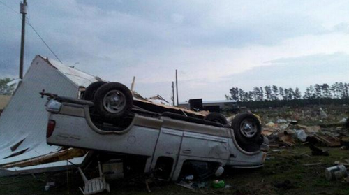
The beginning of July started off on an active note as hurricane Arthur spun up just off the coast of Florida. Arthur quickly organized, pushing out the dry air that was initially a problem on the northwest side of the storm. Following the short bout with the dry air, Arthur formed a well-defined eye. The storm “only” reached category two as it made landfall on the Carolina coast near Cape Lookout, shortly after forming the well-defined eye. It brought with it sustained winds of 160km/h, whipping up a significant storm surge as high as 1.4m on the outer banks.

Base reflectivity radar image of Arthur shortly after it made landfall on the outer banks of North Carolina very early on July 4th. (Source: GRlevel3)

In the aftermath of the storm 41,000 residents from North Carolina had lost power, in addition to some minor damage to houses. Flooding was also a concern where a few areas received over 100mm of rain from the storm. Thanks to much warning in advance, no residents were injured or killed with this storm. Arthur brings an end to the lull in hurricane activity the United States has seen in the past couple years. The last hurricane to have made landfall in the United States prior to Arthur was in August, 2012.

Arthur further continued its trek up the East Coast bringing miserable weather to the US Northeast as well as Atlantic Canada, but was less of a threat (still significant) as a post-tropical storm.

Super Typhoon Neoguri
Super typhoon Neoguri was another significant storm that spun up to start off the month of July, this time in the western Pacific Ocean. With the help of very warm sea surface temperatures as well as little shear to tear it apart, Neoguri strengthened to a super typhoon producing sustained winds of 250km/h and bottoming out at a pressure of 930mb. Six deaths have been attributed to Neoguri as well as over 100 injuries. After passing through the Ryuku Islands, Neoguri got caught up in the polar jet stream and curved back east towards Japan as it started its transition to an extratropical storm over Japan. Satellite observations indicated rainfall totals of over 500mm in a few mountainous regions of Japan. Neoguri was officially declared an extratropical storm yesterday.

Another disturbed area is currently over the Pacific and is expected to become of tropical storm strength this weekend, however, is not expected to impact any landmasses in the near future.

Elsewhere in Weather News: April 26th, 2014

Tornadoes Tear through North Carolina

It was an active day severe weather-wise for parts of East Coast yesterday, where tornadoes, large hail and strong winds were all experienced. These severe storms were triggered by a shortwave racing across the mid-section of the US and approaching the East Coast. Moisture was plentiful streaming up from the tropics which promoted low cloud bases and sufficient amounts of Convective Available Potential Energy (CAPE). In addition to this, wind shear was significant enough to support supercells as well as an approaching cold front from the west acting as a trigger mechanism. Considering all of these, conditions were primed for supercells in North Carolina and Virginia.

Trucked flipped in Chicod, NC. (Source: WITN)

Supercells quickly formed Friday afternoon across eastern parts of North Carolina and Virginia as the atmosphere destabilized. Elizabeth City appeared to be the hardest hit, likely by straight line winds and not a tornado. As of Friday evening, several injuries were reported because of the strong winds downing trees and power lines in the city. According to the SPC there were 10 different tornado reports which appeared to account for three different tornadoes. Fortunately, no injuries or deaths were reported to be associated with any of the tornadoes.

This event comes at the same time a significant negatively-tilted trough arrives ashore on the west coast. The trough is expected to bring severe weather from the US plains this weekend, to the East coast for the beginning of next week. Sunday through Tuesday look to be the most dangerous days where numerous tornadoes could touch down across Dixie Alley and the Midwest. As of Friday evening, the SPC had already issued a Moderate Risk, mentioning strong tornadoes in their discussion and suggesting a high risk (highest tier) upgrade could be in order in future updates.

With only 89 tornadoes reported in the US as of April 13th, that number could easily double within the next few days.