Warm Weekend Ahead for Winnipeg

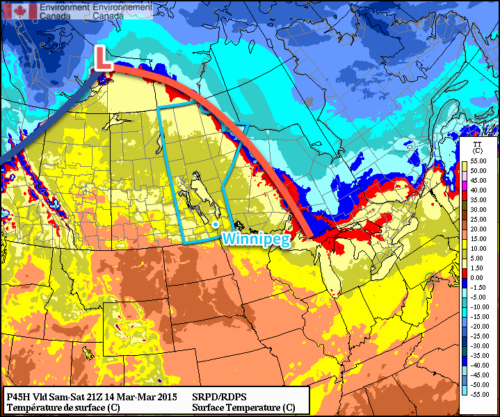
Winnipeg & the Rest of Southern Manitoba will see a beautiful weekend ahead thanks to a powerful low pressure system set to track through the Arctic, drawing warmer air northwards into the Prairies. The result will be a dry weekend with temperatures soaring well above normal with a fair amount of sunshine to enjoy. The pleasant March weather continues!

RDPS Surface Temperature – 21Z March 15, 2015
The RDPS clearly shows a powerful low pressure system moving north of 60° with a broad frontal system pulling warmer air northwards into the Prairies.

Today will be the coolest day of the next few with a high temperature near 5°C. Skies will start off cloudy but should clear out as the day progresses. Winds will be out of the northwest to 20-30km/h. Expect temperatures down to around -1°C overnight.

Friday
5°C / -1°C
Clearing

Saturday
9°C / 5°C
Mainly cloudy

Sunday
12°C / 0°C
Partly cloudy

Saturday will a transition day as the warm front moves through Southern Manitoba. It will be warmer than Friday, but accompanying those warmer temperatures will be gusty southerly winds to around 40km/h. Skies will be mainly cloudy as temperatures climb to 9°C with no chance for precipitation. With warmer weather moving in, overnight lows will be quite mild near 5°C.

Sunday will be a gorgeous day. Any remnant cloud from Saturday’s warm front will clear out by the end of the morning and we’ll be left with mainly sunny skies with high temperatures climbing into the low teens. Winds will be relatively calm until later in the day when winds will pick up out of the northwest to around 30km/h. Cooler temperatures will move in bringing overnight lows back towards the 0°C mark.

Next week continues to bring mild weather with no signs of any potential precipitation until the end of the week. With much of our snow likely gone by the end of the weekend – and the snowpack pretty much gone in North Dakota – it’s a fairly safe bet to say that spring has arrived in full!

Nice Week Ahead!

This week will be quite nice, as a fairly consistent summer-like pattern takes hold.

Monday will be a pleasant day in southern Manitoba

Monday

Monday
24°C / 12°C
Mainly Sunny

Today will be coolest day of the week, but that isn’t actually a bad thing in this case. We should see temperatures climb into the low to mid twenties with light northerly wind. Some smoke from forest fires in northern Canada may trickle into southern Manitoba, but otherwise skies should be mainly clear.

Tuesday

Tuesday
26°C / 14°C
Mainly Sunny

Tuesday look very similar to Monday, except it’ll be slightly warmer. Temperatures in the mid twenties are expected once again, with a light northerly wind. Again, there may be a bit of smoke around, but otherwise it’ll be another great day.

Wednesday

Wednesday
28°C / 16°C
Mainly Sunny. Slight chance of a shower or thunderstorm.

Wednesday should see pleasant continue continue. Temperatures will likely reach the upper twenties in most areas, once again under a light northerly flow. Wednesday’s airmass looks to be a bit more humid than what we saw earlier in the week, so a few pop-up showers and/or thunderstorms are possible in the afternoon and evening. However, these will be very hit and miss, so most people will not be affected.

Long Range

The long range forecast is looking good. Models depict a large upper ridge building over the Prairies this week. That should mean generally hot and dry weather for us. Long range models suggest this ridge may stick around for most of the next 10 days.