Elsewhere in Weather News: February 15th, 2014

US East Coast Experiences another Blast of Winter

Yet another winter storm has affected the US Southeast and eastern seaboard this past week. The low pressure quickly organized just offshore over the warm waters of the Gulf Stream, but at the same time dragging down brisk Arctic air all the way down to the southern states such as Georgia and Alabama. As the low pressure system moved north, just off the coast it quickly became a “meteorological bomb”. A meteorological is defined by a low pressure deepening 24mb in 24 hours, which means deep intensification is occurring. It’s not uncommon to see this occur off the coast in winter because of the large contrast between ocean and land temperature, but is uncommon to see this happen in the middle of the continent.

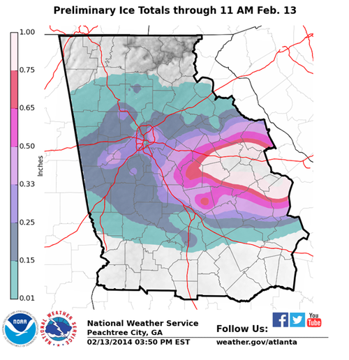
Due to this storm, over 6,000 flights had been cancelled across the eastern seaboard and services totally shut down in the south for 36 hours because of the storm. It appears that the worst damage occurred from Augusta Georgia, westwards, to just south of Atlanta. Here ice accumulation totals approached 2.5cm which made trees and power lines top heavy and eventually collapsing. Snow amounts in the northeast US were also impressive, where snow rates of 10cm/h fell in the heaviest bands. The highest reports were 70cm in South Berne, NY and 61cm in Shrewsbury, VT. Thundersnow was also reported just west of New York City as multi-cell thunderstorm clusters drifted north of the warm front and transitioned to snow producers.

Ice accumulation with the latest winter storm affecting Georgia. (Source: NWS Atlanta)

Residents should not put their shovels away quite yet though as a strong low off the coast is expected in the Wednesday-Thursday timeframe next week which will be another big weather producer for the East Coast.

Elsewhere in Weather News: December 23rd, 2012

From Snow to Tornadoes in the US this Week

This past week a large trough of low pressure swung through the eastern half of the United States bringing a wide range of weather; from blizzards in the Midwest, to tornadoes in the South-East and even dust storms in Texas.

The tornado, confirmed by the National Weather Station, occurred in the early morning hours on Thursday and cut a path of destruction through Mobile, Alabama. Preliminary reports indicate that the tornado was of EF-1 strength (between 138km/h and 178km/h winds) and had a path spanning 11 kilometers. It tore down roofs, uprooted oak trees and cut power off to about 10,000 residents. Most of the power was restored by Friday but the cleanup will certainly still be underway this weekend.

Blizzards, spanning from Nebraska to Michigan, accompanied this potent trough of low pressure and thundersnow was even experienced at times. Over 600 flights out of Chicago were cancelled and officials had to close various interstates across the Midwest, simply because it was too dangerous to travel. Here are a few of the higher snowfall amounts recorded as of Friday:

  • Gaylord, MI: 50cm
  • Madison, WI: 34cm
  • Des Moines, IA: 32cm

On Wednesday, near Amarillo, Texas, as the front came through it was accompanied with very strong winds (gusting to 80km/h) which managed to stir up a large dust storm. This dust storm was caused in part by the severe winds but also the severe drought currently occurring in the Southern Plains, including Amarillo, where the dirt is loose and can easily be picked up. The dust storm went through Interstate 27 producing near zero visibility and triggered a 23 vehicle pile-up.
By Saturday the trough will have moved off to Atlantic Canada, much of the US Midwest and Plains will experience below-normal temperatures as arctic air floods in from the Canadian Prairies.

Drought

Significant drought throughout the US Plains, both long-term and short-term. (Source: Drought Monitor, NDMC)

We again wish you happy holidays and all the best in the New Year!