Conditions Settling as Colder Temperatures Build In

Skies will gradually clear this weekend in Winnipeg as the Polar Vortex slumps towards the region.

RDPS 2m Temperature Forecast valid 21Z Sunday February 9, 2025
Temperatures will cool this weekend, but even colder weather will be pushing into the Prairies by the end of the weekend.

A weak disturbance dropping through the region will bring mixed skies to the Winnipeg area today. Temperatures will be similar to yesterday with a high in the -10 to -15 °C range, but winds will be much lighter at only around 15 to 20 km/h.

Skies will clear out a bit tonight, but a disturbance moving through the United States will spread a bit more cloud into southern Manitoba overnight into Saturday. Temperatures will dip down into the -25 to -20 °C range overnight with light winds.

On Saturday, Winnipeg will again see mixed skies with some morning cloud breaking up into the afternoon. Temperatures will be cooler with highs dipping to the -20 to -15 °C range with light winds.

By Saturday evening, the next big pattern shift for the region will be underway. An axis of colder air will begin building into the Prairies as the Polar Vortex begins to slowly drop southwards through the Arctic. This will entrench this first temperature drop into the region through the rest of the weekend.

Lows will dip into the -30 to 25 °C range on Saturday night with mainly clear skies and light winds.

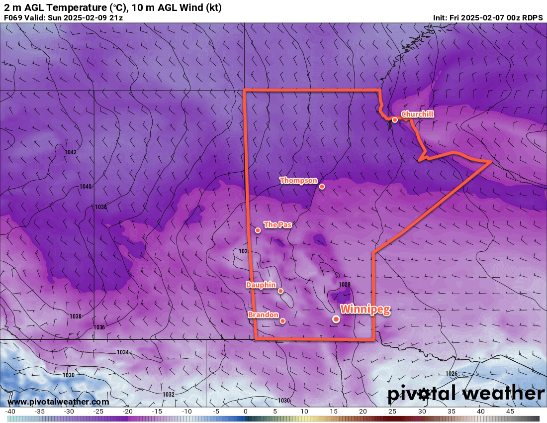
On Sunday, a weak disturbance slumping through along the leading edge of colder air will slide through the region. It will bring mixed to cloudy skies with a chance of flurries to the region. For the Winnipeg area, a bit of snow will be most likely in the afternoon, while it will be earlier to the north and west. Daytime highs will climb back into the -20 to -15 °C range.

Some clouds will linger on Sunday night ad temperatures dip into the mid-minus 20s.

Long Range Outlook

Next week will be dominated by a single weather feature: the Polar Vortex. It will continue to drop southwards and build into the Prairies, bringing cold weather to the entire region.

Daytime highs will drop below -20 °C early next week with lows dipping close to -30 °C. There will be little change in the following 10 days. Daytime highs will largely sit in the -20s, save for the occasional passing disturbance that brings highs into the low minus teens. Overnight lows will dip into the low -20s or -30s many times right into mid-February.

It will be a prolonged stretch of cold weather that shows little sign of breaking down until late in the month. Extreme cold warnings will likely be issued by the weather office at times next week for the region.

We hope you all have a great weekend and we’ll see you back here in the deep freeze next week!

Today’s seasonal daytime high in Winnipeg is -10 °C while the seasonal overnight low is -20 °C.

#awm/below_seasonal_temperatures #Winnipeg #MBwx

Seasonably Cool Weather Ahead With Chance of Snow Mid-Week

A stubborn Arctic High will keep temperatures on the cool side this week across Manitoba. Sun will give way to cloud, though, as a developing low in the United States looks likely to bring snow to the region.

RDPS 24hr. Snowfall Accumulation Forecast (Kuchera SLR) valid 12Z Thursday February 5, 2025
A disturbance tracking through the United Staes will spread a swath of fluffy snow across southern Manitoba this week.

An Arctic high over the region will keep winds light and temperatures cool in Winnipeg today. A sunny start to the day will give way to mixed skies as some high-level cloud begins to stream into the area from the southwest. This cloud cover is part of a low pressure system developing in the United States that will continue to extend its influence northwards over the next couple days. The Winnipeg area should see a high in the -20 to -15 °C range this afternoon with westerly winds of 10 to 20 km/h.

Mixed skies will continue overnight, gradually clouding over by Wednesday morning. Temperatures will dip to a low in the -25 to -20 °C range.

Through the night, snow will spread out of Montana and across southern Saskatchewan and into Manitoba. A broad area of snow will gradually work its way across southern Manitoba through Wednesday into the evening.

Temperatures will climb close to around -15 °C on Wednesday with light southerly winds. The winds will shift westerly in the evening and pick up into the 30–40 km/h range as this system exits the region. Temperatures will dip to a low close to -20 °C.

Indications are that this system will bring a notable snowfall to the region. As the snow pushes into the cold air over the region, its snow-to-liquid ratios (SLR) will climb. These values will likely reach into the 20:1 to 25:1 range and bring rather fluffy snow to the region.

For areas along and south of the Trans-Canada Highway corridor, it looks like 5 to 10 cm is likely by the time it tapers off. For areas north of this, a broad swath of 10 to 15 cm is likely for the Parkland and Interlake regions.

A few flurries will linger on Thursday as west-northwest winds continue in the 30 to 40 km/h range. Skies will gradually clear thorough the day with highs around -15 °C. The wind will drop off with clearing skies on Thursday night as temperatures head into the -25 to -20 °C range.

Long Range Outlook

The long range forecast for Winnipeg looks quiet with no major snow events on the horizon. Arctic highs will continue to dominate the weather pattern here and bring seasonably cool weather right through next week.

Today’s seasonal daytime high in Winnipeg is -10 °C while the seasonal overnight low is -21 °C.

Weekend Snow Brings Early-February Cold Snap to Southern Manitoba

A low pressure system crossing the Prairies will bring more snow to Winnipeg and area this weekend, but its cold front will usher Arctic air back into the region.

RDPS 2m Temperature Forecast valid 06Z Sunday February 2, 2025
A passing low pressure system will bring light snow and another day of seasonably mild temperatures before Arctic air pushes back into the area.

A cold front slumped through the region yesterday evening, northerly winds and cooler temperatures for the end of the work week. Daytime highs in the Winnipeg area will sit in the -20 to -15 °C range today as north winds of 20 to 30 km/h gradually ease. The seasonably cool weather will at least come with sunny skies.

The weather will turn this evening as a low pressure system building into the Prairies pushes cloud over into the region. The cloud cover will help keep temperatures warmer tonight, with lows staying on the warm side of -20 °C before beginning to warm overnight. A warm front will push into the region overnight, bringing some light snow into the region.

Heading through the weekend, a couple waves of light snow will move through Winnipeg with clouds and flurries between them. Temperatures will warm to a high near -5 °C on Saturday as this system pushes the Arctic front back north of the region , then drop to around -10 °C on Saturday night and hover around that mark on Sunday. The region will see southeast winds up to 30 gusting 50 km/h on Saturday ease to light overnight.

While the system moving through the Prairies this weekend will bring a total of 10 to 20 cm of snow to many areas west and north of Winnipeg, the Red River Valley will likely only see 5 to 10 cm of snow by the time it tapers off later on Sunday.

This system will push the Arctic cold front back south through the region on Sunday, bringing moderate northwest winds and colder temperatures. Skies will begin to clear on Sunday night with temperatures heading back down to -20 °C.

Long Range Outlook

Colder weather will settle into the region next week with daytime highs in the -20 to -15 °C for much of the week. A bit of moderation is possible mid-week as a system crossing the northern United States may spread some cloud and light snow into the region as it passes to the south. Cold weather will likely return for the end of thew eek as well with daytime highs possibly dipping into the -20s.

Today’s seasonal daytime high in Winnipeg is -11 °C while the seasonal overnight low is -22 °C.

Warming up in Winnipeg, but Colder Temperatures Lurk Nearby

Temperatures are warming up in Winnipeg, but a battle between warm and cold air is setting up over the province.

RDPS 2m Temperature Forecast valid 06Z Saturday January 25, 2025
A cold front will sweep through southern Manitoba on Friday night, bringing gusty northwest winds and some blowing snow.

To end the work week, a warm front will push through the Winnipeg area this morning. This front will bring a couple centimetres of light snow and moderate southerly winds as it pushes through. The snow will ease midday behind the front with winds shifting to the west. Temperatures will climb to a high near -2 °C this afternoon.

More snow will move into the region this evening, driven by a cold front following the warm front through the province. Another couple centimetres of snow will fall along with northwest winds up to 40 gusting 60 km/h. These winds will send temperatures back down into the mid-minus teens tonight and bring some blowing snow to the region.

Saturday will bring cooler, near-seasonal temperatures back to the region with a high just under -10 °C. Northwest winds will continue through the day at around 30 gusting 50 km/h, then ease off in the evening. A few flurries will be possible in the morning, then skies will clear. Another warm front will push into the region overnight, warming temperatures from a low in the mid-minus teens up to around -10 °C by Sunday morning.

On Sunday, a southwesterly breeze will bring mixed skies as temperatures climb into the -5 to 0 °C range. Temperatures will continue to warm towards the freezing mark on Sunday night as westerly winds of 20 to 30 km/h continue.

Long Range Outlook

Heading into next week, long-range forecasts show mild conditions for Winnipeg with daytime highs regularly near the freezing mark. There’s some uncertainty, though, as to whether the warmth will be able to stay in place over the region.

RDPS 2m Temperature Forecast valid 21Z Monday January 27, 2025
A sharp temperature gradient will set up over Manitoba next week, with above-freezing highs and the south and Arctic cold in the north.

The Polar Vortex is forecast to dip southeast into eastern Canada, and a strong temperature gradient will likely set up across Manitoba as a result. Daytime highs could reach above freezing over parts of southern Manitoba while temperatures into the -20s and -30s will be possible over northern Manitoba. With such a strong temperature gradient in place over the province, minor changes in front location could result in large swings in expected temperatures.

It will likely be a mild week next week, but minor features could also result in brief outbreaks of rather cold temperatures later in the week.

Today’s seasonal daytime high in Winnipeg is -12 °C while the seasonal overnight low is -23 °C.