Mild Weather Challenges Record, Then Slumping Towards Seasonal

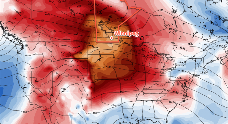
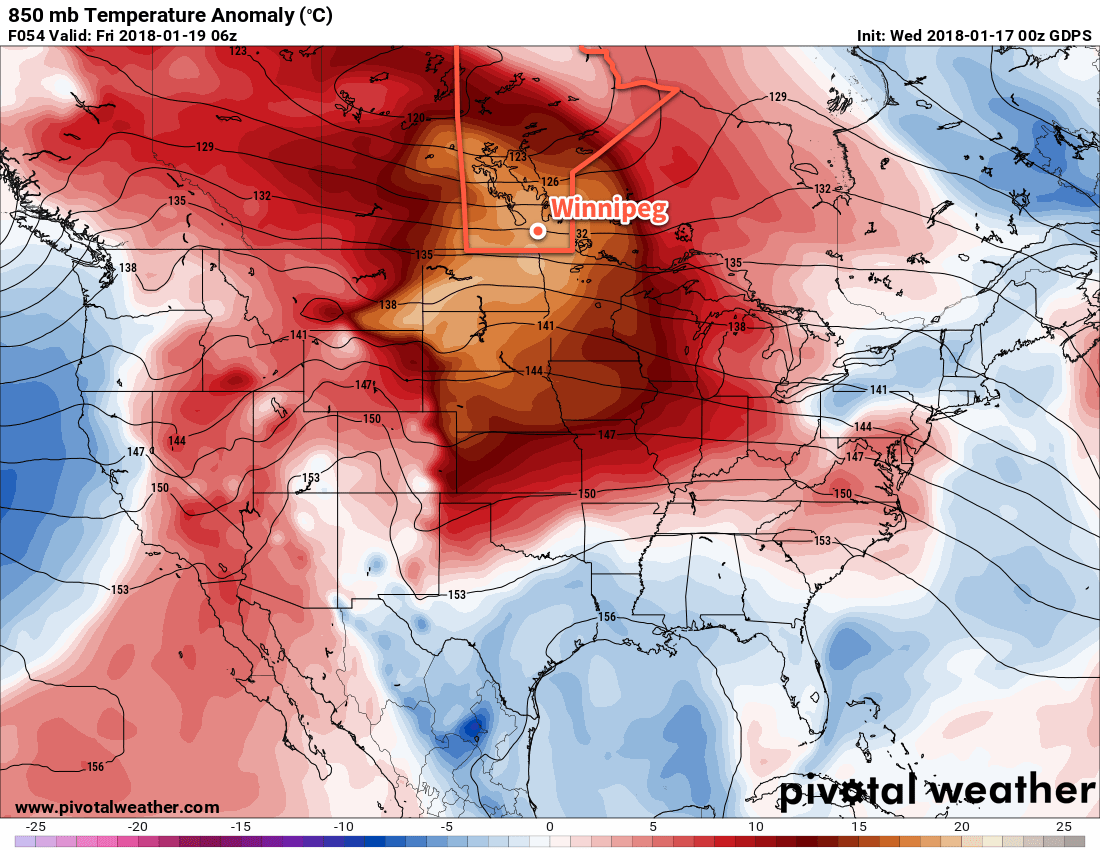
Temperatures will climb well above freezing today and challenge a daytime high record over 100 years old. The significant warmth will ease through the remainder of the weekend, but temperatures are still expected to remain above-normal into the beginning of next week.

Winnipeg will see a cloudy and mild start today with temperatures starting out near 0 or +1°C. Temperatures will climb through the day, reaching a high near +5°C as the sun starts breaking out from behind the clouds later this afternoon. This high will challenge the current daily record high for January 19th of 5.6°C, set first in 1900 and then tied again in 1908. Winds will be out of the southwest at 20 to 30 km/h, gusting at times to 40-50 km/h. Skies will remain partly cloudy for the evening, then cloud back up overnight as a cold front slowly slumps southwards out of the Interlake. Winnipeg will see a low near -8°C.

RDPS Forecast 2m Temperature valid 21Z Friday January 19, 2017
A mild air mass will bring daytime highs near 5°C to the Red River Valley today

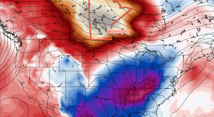
Saturday will bring mixed skies to the city – looking cloudier in the morning and a but sunnier in the afternoon – with a high near -2°C. It’s quite a bit cooler than Friday, but still well above the seasonal high of -13°C. There isn’t too much else to say! Saturday night will see mainly cloudy skies and a low near -8°C. Sunday will bring mixed to cloudy skies with a high near -5°C and a low near -10°C. Winds will remain light.

Long Range Outlook

The first half of next week will bring variable cloudiness to Winnipeg with temperatures continuing to trend towards seasonal values. No significant snow is on the horizon. All things considered, it’ll be beautiful January weather!

Winnipeg’s seasonal daytime high is currently -13°C while the seasonal overnight low is -23°C.

Mild Weather Arrives in Winnipeg

Winnipeg will finally get prolonged relief from the bitter cold as significantly warmer temperatures will be in place for the next 5-7 days.

Winnipeg will likely see the “best all-around” day of the next week today, as clear skies combine with relatively light west-southwest winds of 15-25 km/h and a high near -2°C to make for simply gorgeous January conditions. Cloud over tonight with a good chance for a bit of light snow to move through but no accumulations are expected. Temperatures will dip to a low near -11°C.

Thursday will bring slightly cooler temperatures to Winnipeg with a daytime high near -4°C and light southerly winds. Skies will remain mostly cloudy for the day, so it’ll end up a bit of a sloppier, dreary day particularly when compared to Wednesday’s bright sunny skies. The cloud will thicken up on Thursday night as a low pressure system races eastwards out of northern Alberta. Temperatures will actually rise to around -1°C by Friday morning as that Alberta low pushes warmer air into the region overnight.

Significantly milder air will spread across southern Manitoba on Thursday night

Friday morning may bring a complication to the morning commute: the potential for freezing rain. As the low pressure system passes through the Interlake, it is expected to develop an area of showers over the Red River Valley.1 The biggest uncertainty is when exactly the showers move in, as temperatures should climb above 0°C by mid-morning. With the day starting near -1°C, it’s likely that treated roads won’t have too much trouble if the rain begins before it climbs above freezing, but extra caution should be taken on side streets and bridges.

The forecast sounding for Friday morning shows moisture streaming in above a prominent above-freezing layer with sub-freezing surface temperatures

The chance of showers should taper off by afternoon, and temperatures will climb to a high near +2°C with winds out of the west-southwest at 10 to 20 km/h. Friday night may bring a bit of clearing as temperatures head to a low near -8°C.

Long Range Outlook

The weekend will continue to bring above-seasonal temperatures, but not quite as significantly as during the week. Daytime highs of -5 to -8°C are expected on Saturday and Sunday with overnight lows both nights near -13°C. Plenty of cloud will remain in place for the weekend. Fortunately, winds will remain light so all in all it should be easy to get outside and enjoy some winter activities!

Temperatures are then expected to return to near-seasonal values next week with daytime highs in the -10 to -15°C range and overnight lows approaching -20°C.

Winnipeg’s seasonal daytime high is currently -13°C while the seasonal overnight low is -23°C.

  1. At this point, it looks like the showers will develop along the upper-level jet that will run from southeastern Montana northeastwards into the Red River Valley then arc straight eastwards into Ontario, roughly aligning along the cold front, across the triple point, and down the warm front associated with the Interlake low.

Arctic Grip Gives Way to Mid-Week Warmup

Monday will kick off Winnipeg’s week with some bitter cold, but a major warm-up is on the way mid-week, sending temperatures well above seasonal values.

Winnipeg’s Monday morning is starting off with bitter cold entrenched in the Red River Valley as temperatures near -27°C combine with winds near 30 km/h to produce wind chills near -40. That biting cold will stick around much of the day with temperatures only expected to reach a high near -22°C and that northerly wind at 30-40 km/h persisting until midday before tapering off this afternoon. Skies will gradually clear through the day as an Arctic ridge builds in from the northwest. Tonight will be another cold one as temperatures dip down to around -29°C, but winds will be much lighter, making everything a little more palatable.

RDPS 250mb Wind Forecast valid 00Z Tuesday January 16, 2018
A large upper ridge will begin moving eastwards over the Prairies tonight, spreading significantly warmer air into Manitoba

Everything begins changing on Tuesday, though, as a warm front pushes southeastwards across the province behind the departing Arctic high. A major swell of milder Pacific air will be sweeping eastwards across the Prairies as and upper-level ridge builds across the region. The incoming milder air will bring with it a fair amount of cloud, but temperatures will climb to a high near -16°C with winds out of the south at around 30 km/h. Temperatures will remain relatively mild overnight as more warm air pushes eastwards, bottoming out around -18 or -19°C.

GDPS 850mb Temperature Anomaly Forecast valid 12Z Wednesday January 17, 2018
A significantly warmer-than-seasonal air mass will move into Manitoba on Wednesday, shown clearly here by the departure from seasonal 850mb temperatures

The warmth arrives in full on Wednesday as skies clear out, winds taper off, and temperatures climb to a high near -6°C. Wednesday night’s low near -10°C will even be warmer than the seasonal daytime high of -13°C!

Long Range Outlook

The mild weather will continue for the remainder of the week with highs in the -8 to -4°C range and lows near -10°C.

Temperatures are expected to return towards seasonal values for the weekend with cloudier skies and a chance for some light snow.

Winnipeg’s seasonal daytime high is currently -13°C while the seasonal overnight low is -24°C.

Cold Conditions Continue through the Weekend

A slight warm-up on Sunday won’t make much of a difference: cold weather continues into the first half of next week.

Winnipeg will be locked under the influence of a sprawling Arctic high that will keep daytime highs around -20°C both today and tomorrow under sunny skies. Temperatures will once again dip back down towards -30°C tonight, but some cloud pushing into the area late Saturday ahead of some warmer air pushing in will temper the cold a bit and keep overnight lows to around -25°C. Winds will be light at 10 to 20 km/h today, tonight and tomorrow. Winds will pick up out of the south on Saturday night to around 20 to 30 km/h as skies cloud over.

A few flurries will move thorugh portions of southern Manitoba on Sunday morning.

A passing low pressure system will bring some light flurries to the Red River Valley on Sunday morning as slightly warmer air pushes into the region. Temperatures should climb to a relatively balmy – but still below seasonal – minus 16°C or so with winds shifting to the northwest midday and picking up to around 30 km/h. Skies will clear out overnight as temperatures head to a low near -28°C.

Long Range Outlook

Early next week will see bitter cold return to the region as another Arctic high arrives. Highs will fall into the mid-minus twenties on Monday with overnight lows again near -30°C. A big change is on the horizon, though, as the large-scale weather pattern begins a pretty significant shift and an upper-level ridge starts building into the Prairies. By mid-week, daytime highs are expected to climb towards -5°C, with the potential of near-0°C highs by the end of the week!

This shift to milder weather will come with variable cloudiness with little chance of snow.

Winnipeg’s seasonal daytime high is currently -13°C while the seasonal overnight low is -24°C.