Weather Forecasts, Facts and News for Winnipeg & Southern Manitoba
Author: Brad
Brad lives in Winnipeg with his wife and two children and is the founder of A Weather Moment. He has loved weather from a very young age and has followed that passion through his life so far. He received a B.Sc. in Earth Sciences with Specialization in Atmospheric Sciences and is currently employed in the field of meteorology. You can find the author as WeatherInThePeg on Mastodon.
After cooler-than-normal weather set up over Winnipeg & the Red River Valley behind last Thursday’s low pressure system, it looks like more seasonal warmth is poised to return to our region as plenty of sunshine makes a return.
Today will see steady improvement with the gusty northerly winds in place this morning gradually tapering off as the cloud cover moves out of the region. By the afternoon we should see fairly sunny skies with a high near 20°C. Expect mainly clear skies and a low near 8°C.
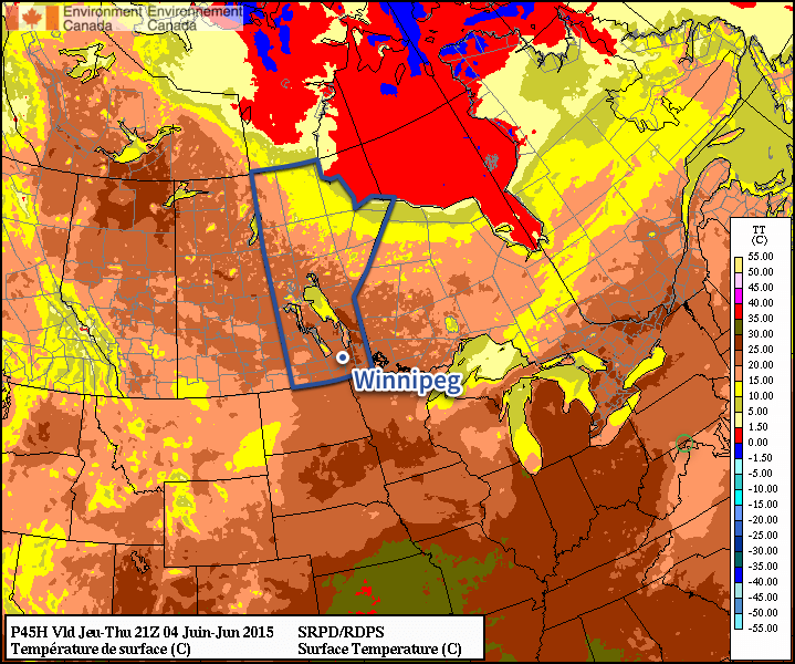
The RDPS is forecasting high temperatures near 25°C on Thursday across much of Southern Manitoba.
The second half of the work week looks great with both Thursday and Friday seeing highs in the mid 20’s and little in the way of significant wind. Thursday looks mainly sunny while a bit more cloud looks possible on Friday as a low pressure system moves north through Western Manitoba. No rain is expected.
Weekend Outlook
The weekend will bring back the chance for some rain with a system moving through on Saturday. Otherwise, the weather seems fairly nice with temperatures in the mid–20’s.
Just when it felt like Winnipeg was out of the woods and summer had arrived, conditions will make it feel like the clock has been turned back to the beginning of the month with temperatures 10°C below normal and a risk of frost returning for the weekend. The cooler weather is courtesy an Arctic airmass that is plunging southwards behind yesterday’s potent system that brought rain & thunderstorms to Saskatchewan & Manitoba.
Today will be a very cool day with brisk northerly winds at 30km/h with some gusts up to around 50km/h. Today’s high will top out at just 11–12°C through the Red River Valley with mixed-to-cloudy skies until the afternoon when things begin to clear up. Winds will ease tonight with temperatures plummeting towards the freezing mark. Winnipeg will just be ahead of the main ridge axis, making sub-freezing temperatures quite possible. Areas near the core of the city may escape frost, however anywhere closer to outskirts of the city will have a strong chance of seeing some frost. The low will vary depending where in the city the temperature is measured, but in general I expect it to be around 0°C with temperatures possible 1–2°C colder than than near the outskirts of the city. Rural areas will likely deal with overnight lows of –1 or –2°C.
The remainder of the weekend looks much calmer but still cool. Saturday and Sunday will see high temperatures returning back towards the mid-teens with mainly sunny skies. Some cloud will push through late Saturday through early Sunday which should help keep the overnight lows in the low-to-mid single digits.
A Glance At Next Week
The start of next week will bring a return to more seasonable high temperatures in the 20’s, however alongside the warmer weather comes the potential for more unsettled weather as multiple systems track through the Southern Prairies & Northern Plains.
As such, Southern Manitoba will likely be dealing with a decent chance for showers or rain through the first half of the week. Depending on how things develop, rainfall totals could be anywhere from a trace to over an inch, so we’ll be sure to track things as the weekend progresses. The weather looks to settle down for the second half of the week with daytime highs in the upper teens to lower 20’s.
The heat is on the way to Southern Manitoba as warmer air finally spills eastwards bringing positively summer-like weather to the area.
There is astonishingly little to say about the coming few days. Temperatures will climb into the mid–20’s Friday, Saturday and Sunday with overnight lows near 11 or 12°C all 3 days. Winds will be fairly light with the slight possibility of some breezier conditions on Saturday afternoon, but even there it would only likely be 20–30km/h. No precipitation is expected, although there will be a slight chance of some showers on Saturday north of Winnipeg along a very weak cold front from Dauphin eastwards across the Interlake.
All in all it will be a perfect weekend to get outside either here in the city or head up to the cottage for a truncated mulligan of the May long weekend!
Uncertain Start to Next Week
The beginning of next week presents another interesting forecast challenge as yet another Colorado Low forms and pushes northwards into the Dakotas. Model forecasts currently diverge quite a bit, demonstrated easily by the current forecasted storm-total precipitation for Winnipeg produced by each one:
Forecast Storm-Total Precipitation for Monday’s Colorado Low
Model
Storm-Total Rainfall (mm)
GDPS
16
NAEFS
8
GFS
0
In general, amounts increase to the south and east of Winnipeg in all the forecast scenarios. Why the big difference? The track of the Colorado Low will depend significantly on how it interacts with thunderstorm activity that develops through the Central Plains as it ejects northeastwards from Colorado. If the convection forms close to the upper-level low and has a significant amount of moisture wrap into it, it will strengthen more, tilting the entire upper-level trough and pulling the system further northwest. If the moisture from the convection pulls off to the east over the upper-level ridge, then the system will be a bit faster, weaker and further southeast.
At this point, there’s still far too much disagreement in the models to make much of a forecast. Overall, the GDPS – currently forecasting the highest amounts for Winnipeg & the RRV – tends to produce too much convection and over-develop lows. They’ve made significant improvements in the latest version of the GDPS, but it still tends to have that strong bias which results in slower systems further to the NW. I think the GFS solution of nothing at all to likely be missing the mark and not quite worth banking on.
That leaves us with the middle-of-the-road answer. Likely some rain on Monday, however not likely as much as advertised by some weather sources right now. We’ll certainly keep an eye on things as they develop and have some updates later in the weekend on how it looks like things are developing.
But for now, get out there and enjoy the hot & dry weather!
A quiet week is ahead weather-wise as an upper-level ridge over the region dominates the weather for the remainder of the week. No precipitation is anticipated for the rest of the work week while temperatures slowly climb to above-normal values.
Wednesday
19°C / 4°C
Sunny
Thursday
20°C / 9°C
Sunny
Friday
24°C / 12°C
Partly cloudy
The next few days will be mainly sunny with just a few more clouds working in on Friday. No rain is expected. Daytime highs will start near 19°C today and climb to 24°C by Friday. Overnight lows will remain chilly tonight with lows just near 4°C, but then push towards above-normal of 9–12°C.
Long-Range Outlook
Overall, the weekend is looking quite nice. Temperatures will be in the low-to-mid 20’s with overnight lows in the upper single digits. Some showers or thunderstorms will be possible along a weak cold front draped across the province – likely north of Winnipeg through the Interlake – but at this point anywhere along or south of the Trans-Canada Highway looks fairly dry.
Heading into the start of next week, though, some models are hinting at the possibility of another – albeit weaker – Colorado Low impacting southern Manitoba. The GDPS[1] is forecasting a very rainy Monday with elevated convecting drenching Southern Manitoba with over an inch of rain. The NAEFS[2] takes a more middle ground approach and pushes a weaker system a bit further east, with our region being grazed and getting something in the 5–10mm range. The GFS[3] produces the weakest solution with an even weaker low pushed even further east with little-to-no impact on Southern Manitoba.
It’s too early to say too much about that system other than we’ll be sure to keep an eye on it as we head into the weekend. There are numerous factors which make it look not nearly as bad as the storm we had over the long weekend, so even though it may be the 3rd Colorado Low in 2 weeks, it may not be a significant issue for the region.
Global Deterministic Prediction System – The Canadian long-range forecast model. ↩