Windy, Unsettled Weather Marks Pattern Shift

Windier, snowier weather is on the way for Winnipeg and the Red River Valley, marking the start of a large-scale pattern shift which will bring the latest – and hopefully last – deep freeze to an end and allow more seasonal weather and temperatures to take hold.

Wednesday
-9°C / ⇑ -6°C
Windy & cloudy. Blowing snow possible. Snow in the afternoon.

Thursday
-1°C ⇓ / -18°C
Snow ending midday; breezy with temperatures falling in the afternoon.

Friday
-12°C / -20 to -25°C
Mainly sunny.

A Windy, Snowy Shift

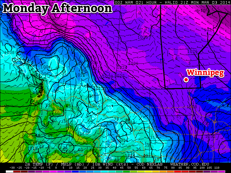
Warmer air trying to build its way into the Red River Valley will result in increasing southerly winds today. By early this afternoon, winds will be quite strong out of the south at 40-50km/h with gusts as high as 70km/h. These strong winds – coupled with a fairly deep boundary layer – will likely produce fairly widespread blowing snow in the Red River Valley. It’s severity may be limited by relatively mild temperatures, however it’s best that anyone travelling on area highways be prepared for poor driving conditions.

Warmer air at 850mb (denoted by the yellow/red colours) will be pushing northeastwards over the next 24 hours.

By late in the afternoon, the upper-level portion of the warm front will be approaching the Manitoba border. A strengthening jet[1] overriding the 850mb baroclinic zone will provide a fair amount of isentropic lift. As the jet intensifies, as will the area of light snow pushing into Parkland Manitoba this morning. It will progress eastwards through the day and push through the Interlake and Red River Valley mid-to-late this afternoon.

It seems likely that Winnipeg will see around 2cm of snow that falls as a fairly intense, but short, burst. Areas south of the city will be more hit and miss as to whether or not snow falls. The safe thing to say is that you’re more and more likely to see snow the further north you are in the valley.

By evening our temperature will climb up to our daytime high of about -9°C. Overnight will bring the continued chance for flurries/light snow while winds diminish somewhat and temperatures continue to rise to around -7 or -6°C here in Winnipeg.

Expected storm-total snowfall by Friday morning. Snow will fall in 3 main batches.

Thursday looks to bring more snow to Winnipeg & the Red River Valley as a clipper system races along the Canada-US border. Snow will move in fairly early in the day, spreading eastwards along the Trans-Canada corridor into Winnipeg, and end early in the afternoon. In total, around 5cm is likely to fall through the morning hours – with a little less to the south of Winnipeg – while accompanied by breezy winds out of the south at around 30km/h. Winds will become gusty out of the NW at 30-50km/h in the afternoon as the system tracks off to our east.

Temperatures will climb to a positively balmy -2 or -1°C by midday before the northwesterlies begin drawing in cooler air.

Flurries & Cooler

Thursday night will bring a good chance of seeing some flurry activity as another ridge of high pressure builds in from the NW and some favourable snow-making air slides southeastwards through the region. Any accumulations would amount to only a couple cm at most, and through the night the clouds will break up and we’ll be left with partly cloudy skies by Friday morning.

Friday itself will bring cooler temperatures with a high of only around -12°C and light winds. Some cloud cover Friday night will help temperatures from dipping too much, with overnight lows dipping just below -20°C.

Spring Ahead?

Hope finally lies in the long-range models. Almost all are showing a high probability of a return to seasonal temperatures[2] within the next 2 weeks. No significant cold snaps are in the foreseeable future, and with the sun getting stronger and stronger and the days getting longer and longer, it doesn’t seem likely that we’ll see any more brutal cold snaps for the miserable winter of 2013-2014.

Don’t forget that this coming Sunday, March 9th at 2:00AM we get to do that wonderful[3] tradition of changing our clocks! We spring forward an hour, so it’ll be time to cash in that extra hour you banked way back in the fall!


  1. A “jet” is a narrow ribbon of strong winds aloft.  ↩
  2. Which will be for daytime highs near -3°C and overnight lows near -13°C.  ↩
  3. Awful.  ↩

More Cold

This week will see below-normal temperatures continue, though it won’t be quite as cold as the weather this past weekend.

Cold weather will continue in southern Manitoba on Monday

Cold weather will continue in southern Manitoba on Monday

Monday

Monday
-18°C / -27°C
Increasing Cloudiness

Today is off to a cold start, but temperatures will increase a fair bit through the day. This afternoon should see highs reaching into the minus teens, a nice recovery from this morning’s low. The wind looks to remain light, making daytime conditions reasonable.

Tuesday

Tuesday
-15°C / -23°C
Mainly Sunny

Tuesday will see daytime temperatures improve a bit over Monday’s values. Highs will be in the mid minus teens with light winds, making for a generally pleasant day.

Wednesday

Wednesday
-11°C / -24°C
Light Snow

The warming trend will continue on Wednesday as a passing low pressure system ushers in a strong southerly flow. Unfortunately, the warmer temperatures brought in by this strong south wind will be largely offset by the cold wind chill values they will generate. We may also see a bit of snow on Wednesday in association with that weather system, making the day a mixed bag overall.

Long Range

The long range forecast continues to look bleak. There have been some hints of a warm up in about 7-10 days, but there is still too much uncertainly to get excited about that.

In Like A Lion

March will be coming in like a lion as one of the coldest winters in our lifetimes continues on with no end in sight. Some of the coldest temperatures of the season are poised to return as yet another reinforcing blast of Arctic air slumps southwards over the region.

Friday
-19°C / -35°C
Flurries ending midday then clearing and windy.

Saturday
-25°C / -32°C
Sunny & cold.

Sunday
-22°C / -30°C
Sunny.

Flurries Give Way to Deep Freeze

A weak inverted trough moving through Southern Manitoba this morning is spreading flurries across the entire region. The remainder of the snow and cloud will clear out midday as we head to a daytime high of -19°C. Unfortunately, the clearing skies are symptomatic of a brutal blast of Arctic air slumping southwards that will bring us yet another night with overnight lows dipping towards the -35°C range.

850mb temperatures show clearly the next lobe of very cold air slumping into the Southern Prairies.
850mb temperatures show the next lobe of very cold air slumping into the Southern Prairies.

As we move onto the backside of the inverted trough this afternoon, strong northerly winds will move into the region – increasing to 30-40km/h with gusts to 60km/h – and produce localized blowing snow throughout the entire Red River Valley. The situation will resemble the clearing and strong winds we received on Wednesday, however today won’t be as intense as that event.

Winds will taper off this evening alongside our plummeting temperatures as another Arctic ridge of high pressure makes its way into the region. This ridge of high pressure will be driven by a lobe of extremely cold air aloft rotating southwards over the Prairies. Temperatures at 700mb through the core of the cold air is forecast to be in the -35 to -40°C range which puts it as the coldest air in the entirety of the northern hemisphere. This extremely cold air will push our overnight low to around -35°C and combine with winds that will remain around 15km/h to produce extreme wind chill values in the -45 to -50 range.

Sunny and Cold Weekend

Conditions through the rest of the weekend will be benign and cold. Mainly sunny skies will dominate with winds generally between 15-25km/h. Saturday’s daytime high of -25°C will be some 20°C below the seasonal daytime high for this time of year. Sunday will warm to around -21 or -22°C for a daytime high, still well below normal. Overnight lows will dip just below -30°C both nights.

Cold Weather Continues

Unseasonably cold weather will continue through the next week as temperatures very slowly warm. By the end of next week temperatures look to climb back to around -10°C with the chance for a couple of shots of snow through the second half of the week.

The NAEFS 8-14 Day Temperature Outlook

It does look like this miserable pattern begins to break down next weekend into the following week, allowing more seasonal air to push back into our region. The NAEFS 8-14 day temperature outlook is also picking up on the pattern change and finally showing a return to seasonal temperatures.

So be brave; we only need to make it one more week and what is almost surely the last extreme cold snap of the season will be past. This winter has been brutal and will easily sit in the top 3 coldest winters of the last 100 years. Lets all hope that we can shift into a steadier mild pattern through mid-March and start getting rid of this snow.

Environment Canada Dates Changes to Warning Program

Environment Canada released a notice today that dates some significant changes to the weather warning program in Canada. The notice touches on several key areas, however the most noticeable will be the changes to watch/warning types:

WARNING AND ADVISORY CHANGES

BLOWING SNOW ADVISORY
REPLACES
BLOWING SNOW WARNING

FREEZING DRIZZLE ADVISORY
REPLACES
FREEZING DRIZZLE WARNING

FROST ADVISORY
REPLACES
FROST WARNING

EXTREME COLD WARNING
REPLACES
WIND CHILL WARNING

ALSO THE EXTREME HEAT WARNING
REPLACES THE FOLLOWING:
HUMIDEX ADVISORY
HIGH HEAT AND HUMIDITY WARNING
HUMIDEX AND HEALTH ADVISORY
EXTREME HEAT-WAVE ADVISORY

NEW ADVISORIES ADDED (ENGLISH):
=NEW= FOG ADVISORY
=NEW= WEATHER ADVISORY

Several warnings are being downgraded to “advisory” status: blowing snow warnings, freezing drizzle warnings and frost warnings. It’s unclear whether these advisories will be handled through a Special Weather Statement (SWS) or if a new bulletin type will be started. I’m guessing they’ll be addressed as a SWS which could be problematic since SWS visibility has always been a bit of an issue. I can’t complain too much about the changes, although I feel that the blowing snow warning is being mishandled.

In 2012, Environment Canada tightened up the requirements for blizzards[1] to the point where warning-eligible events rarely ever happen on the Prairies. As a seeming acknowledgement of this fact, the blowing snow warning was introduced with slightly more lax requirements[2]. The blowing snow warning has been used substantially in Southern Manitoba where ground blizzards – blizzards that occur with no falling snow – are relatively frequent through the winter months. They generally don’t qualify for blizzard warnings because they are too short-lived or difficult to verify – especially since no weather sites along/south of the Trans-Canada Highway other than Winnipeg, Portage la Prairie and Brandon have visibility sensors.

These events can be quite significant and end up closing major highways. The idea that they’ll be regulated to a special weather statement seems disingenuous to their potential impact. Granted, this is mostly speculation at this point, so it will be interesting to see how they decide to handle advisories going forward[3].

Regarding Extreme Cold Warnings replacing wind chill warnings, I recently wrote a lengthy post that addresses this change and explores, in depth, the problems with wind chill and wind chill warnings.

The Extreme Heat Warning looks like an attempt to unify the way extreme heat is handled across the country. Currently some regions do humidex advisories (we use those here in the Prairies), some use high heat and humidity warnings, some use humidex and health advisories and some use extreme heat-wave advisories. The unification into a single banner for hot, humid weather seems like smart housekeeping.

Lastly, Fog Advisories and Weather Advisories will be added to the repertoire. Fog advisories will be great since there’s currently no official way to highlight significant fog events that can have dramatic impacts on transportation. I’m not entirely sure what a “weather advisory” will be, and as such I imagine we won’t see it much.

One of the other small changes which will likely be most obvious in severe thunderstorm warnings will be the inclusion of certainty of predicted severe weather hazards. This means that in a warning they could tell you that 2” of rain is certain, nickel-sized hail is likely and that there’s a slight chance of a tornado; or they could say that a tornado is certain and there’s a slight chance for dime-sized hail. This is a great step forwards into beginning to convey context in the weather forecast.

All of these changes will be implemented on April 8, 2014.


  1. Changed the required visibility from 1/2SM or less to 1/4SM or less. The requirements of sustained winds ≥ 40km/h and a duration of 6hr. or longer remained unchanged.  ↩
  2. A blowing snow warning requires visibilities of 1/2SM or lower (as opposed to 1/4SM for a blizzard), winds ≥ 30km/h (as opposed to 40km/h for a blizzard) for at least 3 consecutive hours (as opposed to 6 for a blizzard).  ↩
  3. From a developer standpoint, there’s no easy way to even check to see if a special weather statement is in effect for a site. It would be nice if Environment Canada included them in the same feeds for watches and warnings.  ↩