The Week Will Start Hot! Then Fizzle…

This week will start out with some nice hot weather, but then rapidly cool off from there. Fall weather appears to be here to stay.

Temperatures are expected to reach the 30C mark in much of Southern Manitoba on Monday

The NAM model is predicting that temperatures will reach the low thirties in much of Southern Manitoba on Monday

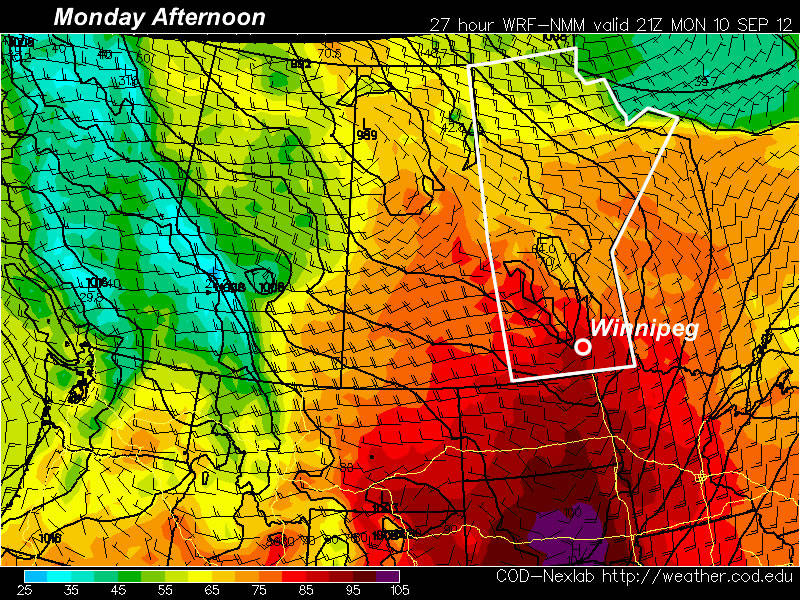
Monday will be one of our last hot days of the year as temperatures climb up around the 30C mark in Southern Manitoba. However, the heat won’t last long, as a cold front will sweep through on Tuesday, bringing cooler weather for the rest of the week. Temperatures from Tuesday through Friday are expected to be fairly typical for mid-September, with values in the upper teens or lower twenties expected. No significant precipitation is expected for the first part of this week, though an odd shower is possible.

At this point most long-range models don’t give a clear picture for how September will proceed temperature-wise. For the most part is looks like we’ll see many normal weather, with some ups and downs here and there. A more interesting long-range weather feature to watch is the development of El Nino conditions in the Pacific Ocean. Most long-term forecasts are calling for the development of weak El Nino conditions in the central Pacific Ocean for this fall and winter. El Nino events tend to bring warmer and drier than normal weather to Western Canada. The stronger the El Nino is, the greater the chance we’ll see a warmer and drier than normal winter here in Southern Manitoba. As we move into winter you will no doubt be hearing more about this topic.

Streamers This Morning; Seasonal Weekend

After lake-effect streamers diminish this morning, we’ll see mainly sunny skies for the rest of the weekend with daytime highs near or just above 20°C.

GFS 500mb Wind Speeds

500mb wind speeds from the GFS model valid mid-day today. Faster winds are shaded. This clearly depicts how Winnipeg is in between the cooler air of the upper low, situated over James Bay, and the warmer air of the upper ridge/high, situated over the Western Prairies.

We’ll see clouds this morning with some showers over the Northern Red River Valley. These showers will be lake-effect streamers, so they’ll impact fairly long, narrow areas downwind of the lakes; where exactly will see showers will be highly dependent on the exact wind direction, so checking out where they are using our RADAR Viewer is your most reliable way to see if you’ll be impacted by them. Winnipeg will likely escape mostly unscathed from the streamers this morning, although should the wind shift to be a little more northerly (more favourable) or westerly (less favourable) we certainly could see some precipitation.

A ridge will slowly start building eastwards across the Prairies today which will bring a more westerly component into our winds across the province this afternoon and help start clearing out the clouds. By mid-to-late afternoon we should see sunny skies with a high right around 20°C here in Winnipeg. Tonight we’ll see clear skies with an overnight low dipping down to about 10°C.

Saturday will bring sunny skies and a high near 21°C as the ridge continues to try and build eastwards. A weak disturbance sliding SE across Manitoba will, however, pull some cooler air southwards across the province which will cause us to have our coolest overnight lows in quite a while across the Red River Valley. Here in Winnipeg, it looks like the overnight low will dip to 6 or 7°C in outlying areas, with temperatures a couple degrees higher near the core of the city.

Warmer air finally is able to push in on Sunday, which will give us a high near 24°C under sunny skies.

The beginning of next week looks to be sunny with slightly above-normal daytime highs.

Seasonable Weather with A Chance of Showers

Feeling chilly after the weather we’ve had lately, more seasonable weather has returned to Southern Manitoba with a slight chance of showers tonight across most areas of the RRV.

The large captured upper low over Northern Manitoba

A GOES East multispectral satellite imagery from Tuesday evening showing the large captured low (denoted by the red L) anchored over Northern Manitoba.

A large upper trough is entrenched over Manitoba, bringing with it cooler air and clouds. Over the next several days, our temperatures will only climb to around the 20°C mark, right around the normal daytime high at this time of year of 21°C.

For today, temperatures will climb to about 23°C before the sky clouds over as a weak cold front passes and our winds increase out of the northwest to about 20km/h with gusts to 40km/h. Clouds will clear out in the evening and we’ll drop to a chilly low of 8°C.

Skies will cloud up again on Thursday as we struggle to hit 20°C. Well have a slight chance of showers through Winnipeg and the Northern RRV through lunch and the early afternoon, however it won’t amount to much if it does materialize.

Temperatures will slowly climb at the end of the week into the weekend. Friday will see mainly sunny skies with a high of 21°C as we have one more day under the influence of the upper trough. As we move into the weekend, warm air pushes in once again, and we should see above-normal highs near 25°C under sunny skies.

A Cooler Weather Regime

Cooler, more seasonable, weather is going to move into Southern Manitoba for the week ahead as a large upper trough swings into the region.

GEM-REG 500mb Winds valid Tuesday Morning

GEM-REG 500mb wind field valid Tuesday morning. A deep upper low is straddling the SK MB border with a trough extending to the SW denoted by the dashed black line.

A strong upper low sitting over the northern Prairies is in the process of stalling out over Northern Manitoba as it’s been captured by a significant long-wave trough. While today will be quite pleasant with sunshine and daytime highs across the Red River Valley near 28°C, the aforementioned trough will be moving into our region tomorrow.

With this system stalled out over the province, we’ll be stuck under cooler air for the rest of the week; daytime highs will sit around the low-20’s under a mix of sun and clouds or cloudy skies. Winds are expected to be fairly light through the week and overnight lows will sit around 10-13°C.

While Northern Manitoba will be fairly wet this week, it looks like we’ll be relatively dry in Southern Manitoba. The best chance for rain looks to be on Wednesday night into Thursday as a small reinforcing trough swings through the Red River Valley. Things then look to improve slightly over the weekend as an upper ridge starts to push across the Prairies, however another powerful low pressure system is forecast to move through Southern Manitoba and bring another batch of cooler air across the Prairies next week as it ushers in another cold trough.