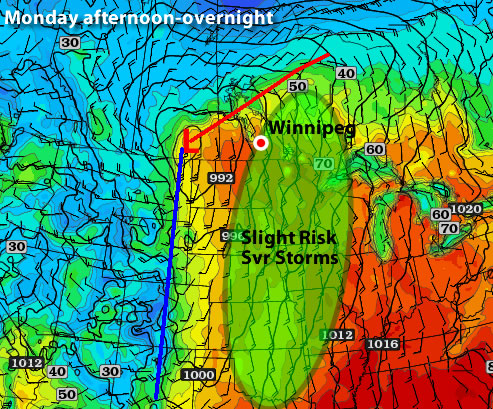
Last week saw Winnipeg bathing in historically abnormal warm weather that shattered numerous daily record high temperatures as well as breaking the record for the warmest day in March since 1872. Thunderstorms then pushed through Winnipeg Monday night, lighting the city up with intense lightning and settling the dust with 10-15mm of rain. On the back side of these storms, cooler air pushed over Southern Manitoba, giving us a daytime high yesterday around 13°C cooler than Monday, which amazingly was still ~10°C above normal for this time of year. Despite the “cool” day, the heat wave isn’t over yet, with temperatures set to rebound to threaten more daily high temperature records over the next few days.
Temperature Records Smashed
| Day | New Record |
Old Record |
Previous Record Year |
|---|---|---|---|
| Sun Mar. 11 | 12.8°C | 12.5°C | 1981 |
| Mon Mar. 12 | 9.7°C | 7.2°C | 1922 |
| Thurs Mar. 15 | 14.4°C | 11.1°C | 1927 |
| Fri Mar. 16 | 19.9°C | 12.4°C | 1981 |
| Sat Mar. 17 | 19.2°C | 12.8°C | 1938 |
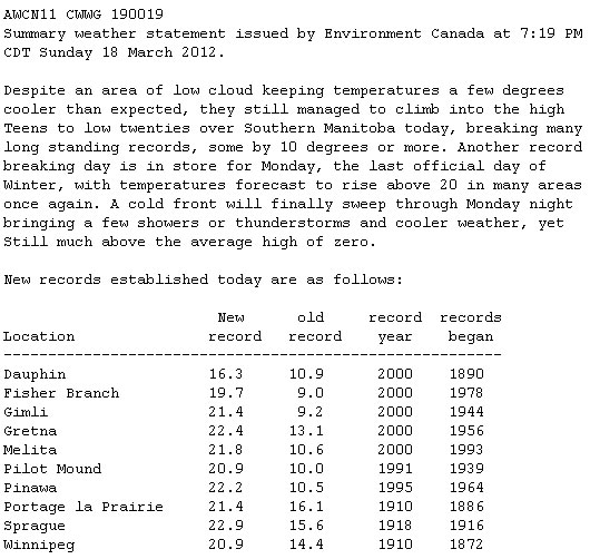
| Sun Mar. 18 | 20.9°C | 14.4°C | 1910 |
| Mon Mar. 19 | 23.7°C | 18.9°C | 1938 |
Winnipeg saw unprecedented heat for the middle of March which broke daily high temperature records on 7 of 9 days. Many records were broken by at least 5°C, and temperatures peaked on Monday, March 19 at 23.7°C, which broke the record high temperature for that day by 4.8°C and broke the old record for the hottest day in March in Winnipeg of 23.3°C set on March 27, 1946. On Sunday, March 18th, Winnipeg had a high of 20.9°C, which was the earliest 20°C reading on record.
Since Friday, Winnipeg has recorded 4 straight days over 19C. In the previous 140 years of March records, that mark has been reached on only 4 occasions in Winnipeg. In other words, it took only 4 days during this warm spell to match what took 140 years to accomplish.
– Rob’s Obs Blog
Perhaps even more impressive was how far above normal temperatures have been. Typically, for the second week of March, normal daytime highs are around -1°C to 0°C. With temperatures rocketing into the high teens, Winnipeg spent almost an entire week with temperatures at least 15°C above normal.
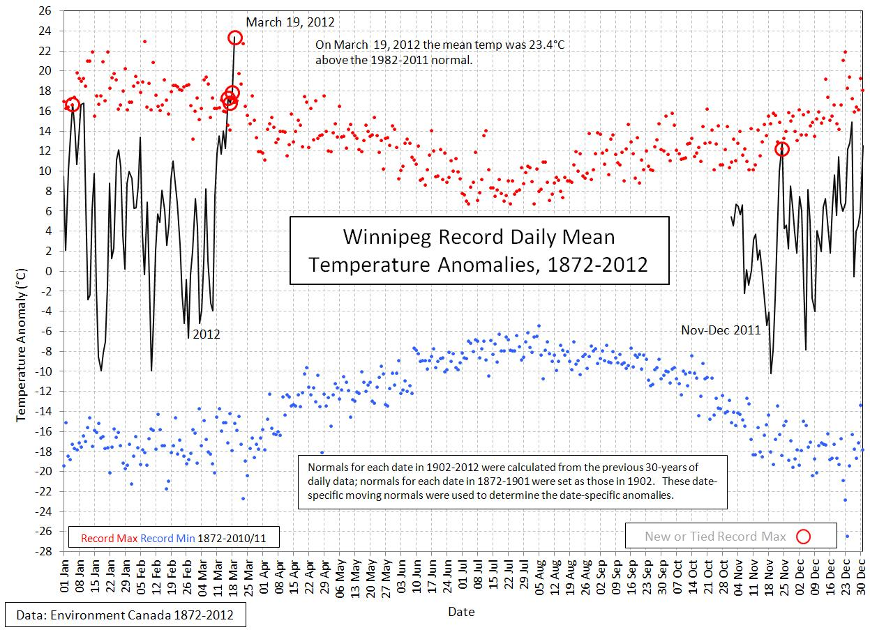
In fact, as the above graph shows, Winnipeg set a new all-time record for temperature anomaly. On March 19th, the daily mean temperature was 23.4°C above normal, which was a higher value than any other day of the year. Winnipeg had never been so far above normal temperatures as Monday.
The Weather This Week
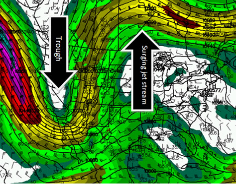
So what’s in store? After a cool Tuesday, temperatures are set to rebound today and tonight, with milder air once again pushing into our region. Today will bring plenty of sunshine with a breezy southwest wind around 30km/h and a high of 14°C. A warm front will push northwards through Southern Manitoba on Thursday, bringing a mix of sun and clouds and temperatures in the upper teens. This warmth will once again bring us the chance of breaking more daily record high temperatures. Currently, Thursday currently looks to be the most likely day we may break a record high temperature. For the next few days, the daily record high temperatures are:
| Day | New Record |
Old Record |
Previous Record Year |
|---|---|---|---|
| Wed Mar. 21 | ??.?°C | 19.4°C | 1938 |
| Thur Mar. 22 | ??.?°C | 18.3°C | 1878 |
| Fri Mar. 23 | ??.?°C | 22.8°C | 1910 |
How about the long term? Ensemble guidance continues to smother central and eastern North America with 90-100% chances of temperatures being above normal.
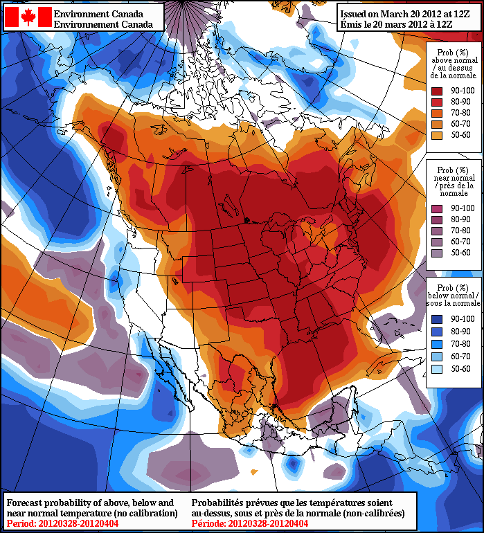
With probabilities that high, while we may have a chilly day here or there, we’ll be hopping right towards summer with little risk of a disheartening return to winter.