After a cloudier Tuesday with a chance of showers, sunny skies will build into southern Manitoba as temperatures climb into the 20s.
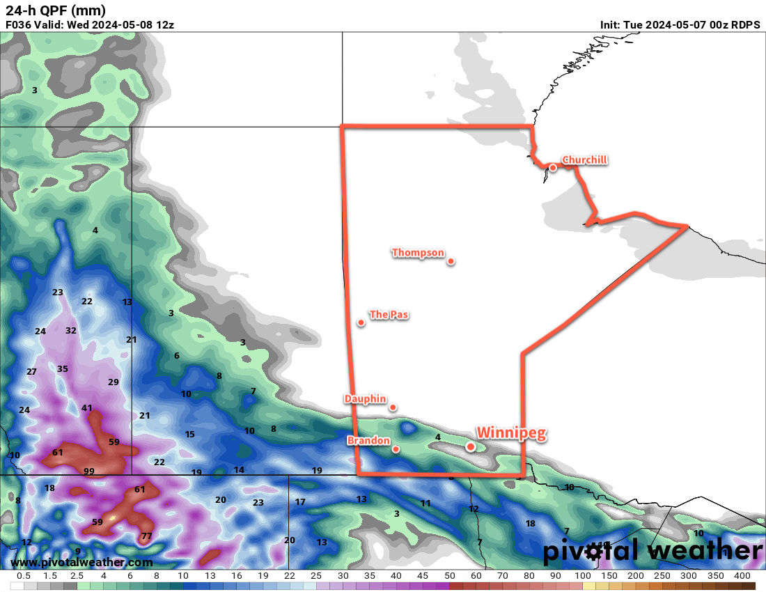
Winnipeg finds itself right on the edge of a broad low pressure system that’s bringing notable rainfall to Alberta and parts of southern Saskatchewan today. This system will likely bring showers to parts of southern Manitoba, but the chance of seeing rain will be highest near the United States border. There will be a sharp cut-off to rainfall as the moisture lifting northwards out of the United States meets a sharp northerly flow over southern Manitoba as it wraps westwards into this system.
The result will be a seasonably cool day — Winnipeg should see a high in the upper teens — with mostly cloudy skies across much of southern Manitoba. Rain near the border will ease to a chance of showers for Winnipeg and many other areas of the Trans-Canada Highway corridor. There will be little chance of rain north of this line. It will be another windy day across the region with easterly winds up to 40 gusting 60 km/h.
Much of the rain will end this evening, save for bands of showers that could continue closer to the US border overnight. Skies will stay cloudy much of the night as temperatures drop to a low near 10 °C and the winds begin to ease.
On Wednesday, any remaining showers near the border will come to an end. A ridge of high pressure will move into the region from the northwest, breaking up the cloud cover and easing the winds. Temperatures will rebound back into the low 20s, making for a more pleasant day than Tuesday. Skies will clear for Wednesday night with a low in the 5 to 10 °C range.
Thursday will be a great day in the Red River Valley. A ridge of high pressure will bring mainly sunny skies and light winds as temperatures climb to a high in the low 20s. Not much more to say than that. A cold front will begin to drop towards the region on Thursday night as a low pressure complex descends from the north. Winnipeg should have mixed skies overnight as temperatures drop to a low in the 5 to 10 °C range.
Lastly, Friday will bring unsettled conditions back to the region. As the cold front and low pass through the area, they’ll bring mixed skies with a chance of showers and even the risk of a thunderstorm. The system will bring northwesterly winds to the region; this could result in little to no chance of rain for Winnipeg as cooler, stable air from Lake Manitoba drifts towards the city in the flow. It looks likely that showers will be widespread over western Manitoba and the Interlake, though, with coverage diminishing further south. Temperatures will top out in the upper teens and head down to the mid-single digits on Friday night.
Long Range Outlook
The weekend will bring more settled conditions again as an upper ridge builds to the west. Winnipeg will likely see partly cloudy skies with highs in the low 20s. Overnight lows should be mild, dropping to the upper single digits.
The pleasant conditions will likely last into the start of next week.
Today’s seasonal daytime high in Winnipeg is 18 °C while the seasonal overnight low is +3 °C.