Weather Forecasts, Facts and News for Winnipeg & Southern Manitoba
Author: Brad
Brad lives in Winnipeg with his wife and two children and is the founder of A Weather Moment. He has loved weather from a very young age and has followed that passion through his life so far. He received a B.Sc. in Earth Sciences with Specialization in Atmospheric Sciences and is currently employed in the field of meteorology. You can find the author as WeatherInThePeg on Mastodon.
After enjoying a couple days of above-normal temperatures, a powerful low pressure system backing into Hudson Bay will drive a cold front southwards across Southern Manitoba today, bringing with it cooler weather.
850mb GEM-Reg Temperature Analysis valid 15Z this morning.
The cold front will sweep through Southern Manitoba late this morning, with winds picking up from the north and increasing to 30-40km/h. Scattered showers will develop along the front as it pushes through the interlake, so most regions in the Red River Valley have a chance of seeing some rain later this morning. It won’t last long, though, and cooler air will stream in on the backside limiting our daytime high in Winnipeg to around 11°C. Skies will clear quickly tonight as an Arctic ridge builds in and helps our overnight low drop to -4°C.
The aforementioned low backing into Hudson Bay will become captured today and will block the eastwards advancement of the Arctic ridge which means, unfortunately, that we’ll be under the influence of the ridge and its outflow for the next few days. Thursday will see sunny skies with a daytime high of only around 9°C, and Friday will be much of the same with a high just a couple degrees warmer. By Saturday it looks like the ridge will start to move off and although the day will still be cool, a southerly flow will begin to bring warmer weather back to our region.
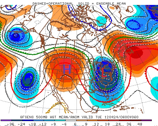
This week will start out on the warm side as a high pressure ridge edges into Manitoba. Temperatures on Monday and Tuesday are expected to reach or exceed 20C, which will mark the first occurrence of a 20 degree reading since April 6.
A large ridge centred over Western North America will bring warm weather to Southern Manitoba on Monday and Tuesday
Highs on Monday should be around 20C in most of Southern Manitoba. Skies will range from mainly sunny to mainly cloudy, with Winnipeg and the Red River Valley tending to be on the cloudier side and Western Manitoba on the sunnier end. As such South-Western Manitoba will likely be a bit warmer than the rest of Southern Manitoba. Tuesday will feature much the same weather as Monday with temperatures once again climbing up to around the twenty degree mark over Southern Manitoba. Skies on Tuesday will mostly likely be a mixture of sun and cloud, preventing temperatures from climbing much above 20 degrees. Should Monday or Tuesday be sunnier than currently expected you can easily add a couple degrees onto the temperatures listed above.
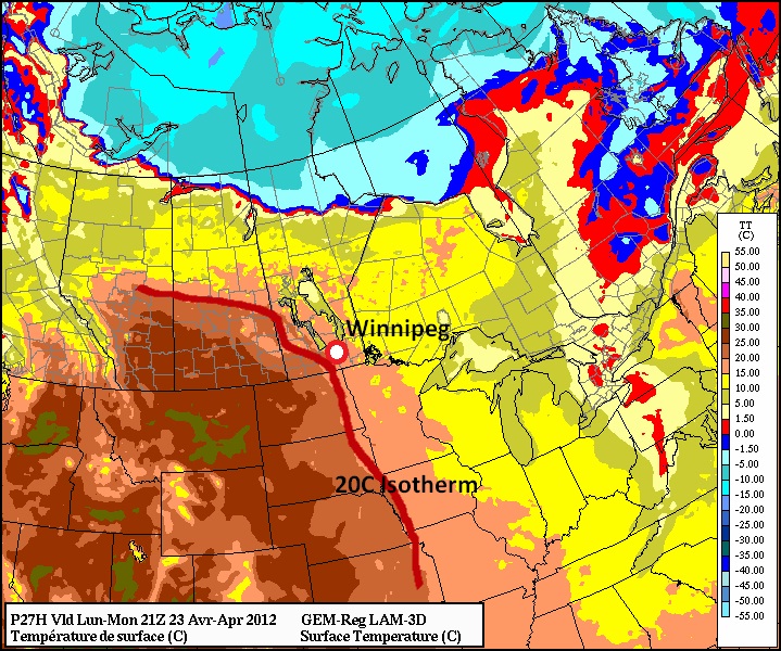
20 degree temperatures are expected in Southern Manitoba on Monday and Tuesday
A cold front will slice through Manitoba on Wednesday, dropping our temperatures back down to normal values. Highs on Wednesday are expected to hover in the low teens in Southern Manitoba, while on Thursday temperatures will remain stuck in the single digits. A recovery in temperatures in expected to begin on Friday and stretch into the weekend.
No significant precipitation is expected this week, although some weak shower activity might form as a low pressure system and associated cold front pass through on Tuesday night and Wednesday.
Elsewhere in Weather News
Australian Rains
As Australia’s summer transitions into fall, heavy rains have pummelled its capital, Sydney, and surrounding regions resulting in flash floods throughout the area.
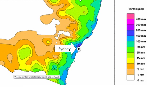
Rainfall map from this past week in NSW, including Sydney’s approximate location. (Source: Bureau of Met.)
Between Monday, April 16th and Wednesday, April 18th, the New South Whales (NSW) region was hit hardest from the flooding where some areas received between 150mm-200mm of rain. The flash floods were triggered by a number of towns receiving rainfall of 40mm/h over a couple hours, and the fact that the soil was saturated in those areas due to heavy rainfall that occurred over the past month.
Parking lot swamped by water. (Source: Seven Network)
Emergency crews were called to assist residents whose cars were overtaken by water and also to help those trapped in their homes as water levels rose in a matter of hours. Utility crews were also busy due to more than a thousand people losing power.
Video of car struggling to cross flooded roads. (Source: mascott1963)
Unfortunately, more rain was forecast to fall this weekend as another slow moving trough/cold front stretched across the whole region. No additional flash flooding was reported with this latest rainfall, however more rainy days are expected to hit the coast this coming week which increases the risk of further flooding in the region where another 15mm-25mm are expected through to Wednesday.
This event comes just two months after the region located north of NSW, Queensland, was hit hard by flooding (brought to you on February 27th post). Australia’s eastern coast has seen its fair share of dangerous flash flooding already this year.
Elsewhere in Weather News has been provided by Matt
After a pleasant Friday, Southern Manitoba will see a showery Saturday as one last system pushes through the province before a large-scale shift in the upper atmosphere brings above-normal weather back to our neck of the woods.
500mb Wind Speed map from the NAM depicting the strong jet core associated with a low forecast to track across Southern Mantioba.
For today, the Winnipeg & the Red River Valley will see sunny skies with milder temperatures, courtesy of the cold trough that we’ve been under the influence of the past few days finally moving off towards the east. We should see a daytime high of about 12°C today, which is right around normal for this time of year.
Tonight, clouds will roll in ahead of a system that is sliding across the Prairies. Showers will push into Southwest Manitoba this evening along a NW-SE line aligned with the lift associated with a strong 90ktjet streak at 500mb. This line will push eastwards through the night and enter into the RRV by morning. The showers should weaken and spread out into a band of light rain by the time it reaches Winnipeg. Although the rain won’t be particularly heavy, the system looks to be relatively slow moving, and because of that it seems like most areas in Southern Manitoba will see between 2-5mm of rain. We’ll refine rainfall amounts in the comments a little closer to the event.
The rain clears out on Saturday evening and clouds will scatter overnight. Skies should completely clear by Sunday afternoon through the RRV leaving us with sunshine and a high near 15°C.
For next week, temperatures will remain in the low teens as an upper ridge begins to build into the Southern Prairies, however we’ll have to wait and see how much sun we’ll have. The potential for several powerful systems to track across the Prairies exists; we’ll be sure to keep an eye on whether or not these systems will impact Winnipeg and the Red River Valley!
Southern Manitoba will see improving conditions today and round out the work week with nice conditions and near-normal temperatures.
Model 3hr. QPF & MSLP w/Surface analysis valid 00Z Thursday April 19th
There will be a slight chance of some light snow this morning over the western half of the Red River Valley as a weak short wave slumps into North Dakota. As it exits the province, clouds will clear and we’ll be left with a sunny afternoon with a high near 8°C.
Clear skies will be the weather story for the rest of the week as a ridge of high pressure builds in from Northern Saskatchewan. We’ll have an overnight low near -6°C tonight and warm back up to a repeat of today on Thursday, with a high near 7°C. Rinse and repeat for Thursday night. As a system pushes into the NW United States, slightly warmer air pushes into Southern Manitoba and we’ll likely see our daytime high bumped up a few degrees to around 10°C.
Saturday brings with it a chance of rain as an upper trough swings across the Prairies. We’ll keep an eye on that as the week progresses!
In short, it’ll be a sunny, albeit a little cool, rest of the week!