Record Setting Heat Across the Prairies

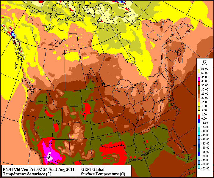
Summer has decided to hang on and not leave us quite yet, bringing record-breaking heat to much of the Canadian Prairies. A large upper ridge build into the region on Tuesday and Wednesday, pushing the jet stream all the way up to the 60th parallel which has allowed a hot, dry southwest flow to remain in place over Alberta, Saskatchewan and Manitoba for days on end. Records have fallen left in right, with some of the highest daily quantities of records being broken at once over the last two days.

How long will this heat stay with us? How hot is it going to get? Click through to read more!

On Wednesday, September 7th, 22 record highs were broken across Alberta, Saskatchewan and Manitoba:

Daily Record Temperatures set September 7, 2011

Location New
Record
Old
Record
Record
Year
Records
Began
Alberta
Cold Lake 30.4 27.8 1998 1953
Fort Chipewyan 27.0 25.0 1937 1884
Fort McMurray 31.0 28.3 1949 1944
Jasper 29.6 29.1 1998 1943
Whitecourt 29.1 26.7 1949 1943
Saskatchewan
Saskatoon 33.4 31.5 1990 1892
Collins Bay 28.0 18.8 1980 1972
Hudson Bay 30.7 30.2 1990 1943
Key Lake 30.0 21.5 2005 1977
La Ronge 29.6 27.7 1980 1923
Meadow Lake 30.2 28.5 1998 1924
Melfort 31.7 31.5 1980 1902
Nipawin 33.0 32.2 1934 1927
North Battleford 33.0 32.2 1893 1880
Rosetown 32.6 32.0 1991 1937
Stony Rapids 27.0 22.7 2005 1960
Manitoba
Fisher Branch 29.7 29.5 1980 1977
Gimli 28.3 27.9 1980 1944
Lynn Lake 29.0 23.9 1980 1952
The Pas 30.3 29.4 1934 1910
Thompson 27.6 24.5 1990 1967

Of note on this day:

  • North Battleford broke a daily record high temperature that was set in 1893, a record 118 years old.
  • Many record highs were broken by at least 2 or 3°C, and some by nearly 10°C.

On Thursday, September 8th, 22 record highs were broken across Alberta, Saskatchewan and Manitoba:

Daily Record Temperatures set September 8, 2011

Location New
Record
Old
Record
Record
Year
Records
Began
Alberta
Cold Lake 30.8 29.8 1981 1953
Coronation 32.2 31.2 1981 1928
Fort McMurray 32.1 30.4 1981 1944
High Level 27.4 26.3 1995 1967
Jasper 30.0 29.8 1998 1943
Sundre 26.9 26.0 1994 1985
Waterton Park 28.3 28.0 1994 1966
Saskatchewan
Saskatoon 34.1 33.5 1981 1892
Collins Bay 24.6 24.1 1981 1972
Hudson Bay 31.7 30.2 1990 1943
Kindersley 33.2 32.8 1981 1913
Leader 34.2 33.5 1981 1924
Nipawin 32.8 32.2 2003 1927
Stony Rapids 24.1 22.3 2003 1960
Manitoba
Fisher Branch 32.1 32.0 2003 1977
Gimli 31.1 30.0 2003 1944
Island Lake 28.1 25.2 2009 1971
Lynn Lake 26.6 23.6 1980 1952
Pinawa 30.7 30.5 2003 1964
Sprague 30.9 29.4 1932 1915
The Pas 30.3 27.5 2003 1910
Thompson 28.0 25.8 2003 1967

And today, September 9th, 2011, 18 records were broken:

Daily Record Temperatures set September 9, 2011

Location New
Record
Old
Record
Record
Year
Records
Began
Alberta
Edson 28.7 27.8 1963 1910
Fort Chipewyan 30.0 27.0 1981 1884
Fort McMurray 32.7 32.4 1981 1944
Jasper 30.4 27.2 1944 1943
Sundre 28.9 25.8 2006 1985
Waterton Park 28.5 27.4 2006 1966
Whitecourt 29.7 29.0 1981 1943
Saskatchewan
Collins Bay 28.0 23.0 2003 1972
Hudson Bay 31.7 29.0 1998 1943
La Ronge 31.0 26.6 1994 1923
Nipawin 32.1 29.2 1981 1927
Stony Rapids 29.1 22.0 2006 1960
Manitoba
Fisher Branch 31.8 31.5 1982 1977
Gimli 31.1 31.0 1982 1944
Lynn Lake 31.1 26.6 2003 1952
Sprague 31.9 30.0 1931 1915
Swan River 31.7 30.0 1998 1908
The Pas 30.7 26.8 2003 1910

This record-setting heat is all thanks to an impressive upper ridge that has built into the Prairies. This is a feature located high in the atmosphere that causes a large area of air to subside (move downwards). Combined with the fact that they build up from the south, they bring a lot of warm air along with themselves, and often result in a large area seeing sunny skies, light winds and hot, dry weather.

The upper ridge will remain in our area for the next couple days, with daytime highs remaining in the low 30°C range. Winnipeg has an honest shot at breaking our daily record high temperature tomorrow which sits at 32.4°C. Things will abruptly change next week however. On Monday a low pressure system will pass by to our north and drag a cold front down across the province. Through the following days, a large ridge of high pressure will build in from the northwest, bringing significantly cooler temperatures than the past week:

GFS Temperatures Valid 06Z Thursday 15 Sept
GFS Surface Temperatures Valid 06Z Thursday 15 September

Currently it looks like next Wednesday and Thursday will be the coldest of the days, with highs struggling to get as high as 15°C. While the last week has been a beautiful late-season blast of summer, fall is set to make an aggressive entrance early next week.

Dry Streak Finally Over

In a new post over at Rob’s Blog, Rob describes exactly how dry it has been this summer in Winnipeg. I recommend you head over and read it, but the highlights are:

  • This summer the CYWG airport site recorded 93.0mm of rain from June to August.
    • This value is over 140mm below average
  • This year was the driest summer since 2006, when only 91.5mm of rain was recorded.
  • Southwest Manitoba and the Southern RRV experienced near-normal amounts of rain while the Northern RRV and Eastern MB experienced the dry conditions this summer.
  • This summer was the 5th driest summer on record.

Be sure to head over to Rob’s Blog to see the whole post and some more details on this summer compared to climatology. All in all, if you enjoy the sun, this summer in Winnipeg has been the summer for you!

The hot and dry weather came to an abrupt end early Thursday morning when Winnipeg received ~20mm of rain as a large complex of thunderstorms rolled through Southern Manitoba, giving large amounts of rain and winds as high as 110km/h over portions of extreme Southern MB. After a day of sun with much cooler temperatures, Winnipeg is set to likely receive another round of showers tonight. Read on to find out what’s in store!

18:15Z Water Vapor Image
Water Vapor (7µm) Image of Canada from 2:15PM CDT. L – Low; Blue Line – Cold Front; Red Line – Warm Front; Green Arrows – Expected Track of Low

A moderately strong upper low is tracking southeastwards across the Prairies today and will slump to the International Border near Melita by late this evening and then slide east along the border, crossing over the RRV overnight. A frontal wave associated with this system will mirror its parent’s motion and slide along the same track ahead of the system, arriving at the western edge of the RRV by early-to-mid evening.

6 Hour QPF from GEM-REG 12Z Model Run valid at 06Z 03 Sept. 2011
6 Hour QPF from GEM-REG 12Z Model Run valid at 06Z 03 Sept. 2011 (1AM CDT)

Showers and isolated thunderstorms will develop along the warm front early this evening, pushing into the RRV around midnight. The rain will push across the RRV and through Winnipeg overnight. Most of the RRV will see only 2-4mm of rain, and there is no risk of severe thunderstorms. Perhaps a bigger story with this system is rainfall totals in areas north of the the low track.

24 Hour QPF from GEM-REG 12Z Model Run valid at 12Z 03 Sept. 2011
24 Hour Total QPF from GEM-REG 12Z Model Run valid at 12Z 03 Sept. 2011

The above picture shows the total amount of rain that is expected to fall from Friday 7 A.M. CDT to Saturday 7 A.M. CDT. Over 40mm of rain are expected to fall across portions of Eastern Saskatchewan, across the Parkland areas of Manitoba including Dapuhin and Minneodsa, through the Interlake and into Northwestern Ontario.


For Saturday, Winnipeg and the rest of the RRV will see the chance of showers as the cold front pushes through in the morning. By early afternoon things will begin to stabilize with the passage of the front, and most of the RRV will see winds of 30-40km/h behind the cold front with gusts up to 60km/h.


Chart of 500mb Heights and Temperatures valid for the evening of Wed. Sept. 7

Things look calm in the long-term, as after this system the upper ridge begins to redevelop aloft. It will continue to intensify through the next week, bringing sunny skies and the return of warmer weather. We should see relatively light winds most of next week with daytime highs in the mid-20’s. Summer isn’t over yet!

Winnipeg Bakes Under Hottest Day In 16 Years; Summer Far from Over

It's a scorcher out there
Winnipeg baking underneath it’s hottest day in 16 years

An extremely warm air mass, combined with brisk westerly winds, brought record heat to much of southern Manitoba. Winnipeg officially reached 37.0C today, breaking the old record of 36.7C set in 1952 and marking the warmest day the city has seen since June 17, 1995 when the mercury soared to 37.8C.

The warm weather spread into Southern Manitoba ahead of a cold front sweeping cooler air into the province by Tuesday evening. A westerly, downslope flow coupled with extremely warm air at 850 mb pushed the mercury to record-breaking levels in many areas across Southern and Central Manitoba, including:

Location New Record Old Record
(Old Year)
Records Started
Winnipeg 37.2° 36.7° (1952) 1873
Fisher Branch 34.2° 31.0° (1990) 1977
Gretna 36.5° 31.1° (1965) 1955
Island Lake 29.1° 27.8° (1976) 1971
Melita 33.3° 32.2° (1997) 1993
Pinawa 35.4° 31.1° (1969) 1964

One thing that was very interesting, though, was that the International Airport in Winnipeg was actually one of the cold spots in the city. Various personal weather stations reported even higher temperatures:

Location Today’s High
Birds Hill Park 38.0°
Charleswood 38.0°
East St. Paul 37.0°
Island Lakes 36.9°
St. Vital 38.8°
Whyte Ridge 37.7°

Fortunately, a cold front passing through this evening will usher in cooler weather and stronger winds. An intensifying surface pressure gradient on the back-side of the cold front will bring strong winds into Winnipeg tomorrow with sustained winds expected to reach 50km/h with the potential for gusts as high as 80km/h. Temperatures will be about 13-15 degrees cooler than today, with highs of 23-25° expected for much of Southern Manitoba.

GEMGLB Temperature for Thursday Afternoon
12Z Aug 23 GEM-GLB Temperature valid 00Z Fri Aug 26

However, after just one cooler day, warmer weather is expected to return to Southern Manitoba. By Thursday afternoon, temperatures should push back up towards the 30° mark with a southerly flow that redevelops through the day. Late Thursday evening a cold front will pass across the RRV, bringing us back into daytime highs of 22-25° for the weekend. Currently, no precipitation is expected with this front, but I’ll keep an eye on it through the week.

Powerful Thunderstorm Rips Through Winnipeg; What’s Next?

Winnipeg Lightning
Photo by Phil Hossack, The Winnipeg Free Press

A powerful thunderstorm developed rapidly along an advancing cold front last night, pounding the city with heavy rain, strong winds and hail. Things looked like they would pass north of the city until the front reached about 30-40km west of Winnipeg, where rapid southward development of the existing storm line occurred. This storm, a rarity this summer, comes after a month and a half of hot, dry weather where thunderstorms constantly split as they approached the city and passed north of our south of the area. For storm lovers, we couldn’t have asked for more from a late-evening thunderstorm: great structure in the clouds, much-needed rain, some hail, and one of the most impressive light shows I’ve seen in a long, long time. Read on to see pictures and video of this storm in action!

I was able to capture this video from the west-end of town around 9:45 last night, shortly after it had stopped raining. I haven’t seen as much lightning in a single storm as the one last night in a long, long time:

Intense Lightning in Winnipeg (August 18, 2011) from buffaloseven on Vimeo

User submitted photo
Photo submitted by @hubertguiggsy on Twitter

Twitter user @hubertquiggsy sent me this picture of the storm. It’s a beautiful shot that shows the gust front crossing the city (this picture is facing North) with ample amounts of scud being sucked up into the storm.

Lightning + Mammatus
This picture is one of a few great ones at http://www.steinbachweather.ca from the storm as it moved through his area, such as the one above. I highly recommend you visit the site and take a look.

The Weather Network always has plenty of submissions, and last night’s storm was no different; here are some of the highlights:

Clouds
Clouds; submitted by Arienna Paul

This shot (Clouds) shows the impressive structure the leading edge of this storm had, with a well-defined lowering and gust front, complete with beautiful striations running along the main lowering.

Wow!
Wow!; submitted by Christina Unger

Seen from a different angle, Wow! shows us how ominous this storm looked as it approached. Scud getting sucked up into the storm as it advanced on the city, with nothing but ominous behind the gust front. Again, striations can be seen running along the gust front on the upper half of the lowering.

funnel cloud
funnel cloud; submit by Wendy Buleziuk

This shot, taken near East St. Paul, shows another beautiful shelf cloud. The photo is titled “funnel cloud” and I chose not to change that, but it’s important to note that there is no funnel cloud in this picture. The elongated strands of clouds pointing towards the lower left of the picture, protruding from the shelf cloud itself, is known as ‘scud’. This is very low level cloud that is generated by strong lift right ahead of the gust front. These clouds are indicative of a powerful thunderstorm, but do not have a direct connection to the development of funnel clouds or tornadoes.

Thunder Storm Winnipg
Thunder Storm Winnipg (sic); submitted by Greg Pecold

Another beautiful shot of the gust front as it advanced into town.


What’s next for Winnipeg? Cooler weather for today and tomorrow with a mix of sun and clouds. It looks like there’s a chance of showers tomorrow afternoon/evening as a weak disturbance slides through the interlake in the northwest flow, although it looks likely that the showers will stay north of Winnipeg. Sunday may be a little more unsettled as another system moves by and starts to push the cold air out of the province. We’ll see temperatures rebound to close to 30°C Sunday afternoon as the system brings warmer air into the province, and then for the first half of next week we’ll be under the influence of a building upper ridge, which will bring sunshine and temperatures near 30°C for Monday, Tuesday and Wednesday.