Editor’s Note: We’ve decided to move our weekly Elsewhere in Weather News from Monday’s post to it’s own post on Saturday mornings! We hope this will encourage a little more discussion in the comments about other significant weather and we feel that Matt has been doing a great job; since this “little segment” has become an interesting part of what A Weather Moment is, it’s only right to acknowledge Matt’s efforts and give him his own space! So without further ado, here is this week’s Elsewhere in Weather News, now on Saturdays!
Storms Run Rampant Across the United States
The SPC has had their hands full with severe thunderstorms across the Upper Mississippi Valley and most of the Midwest as the 2012 storm season gets into high gear as we enter the month of May. The strong storms have caused many power outages to several states, including Iowa and Minnesota. In addition to the dangerous gusts brought by these storms, tornadoes were spotted in Iowa on Thursday and in southern Minnesota on Friday. No injuries or deaths were reported.
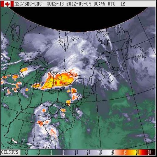
Across most of the Midwest yesterday, storms ranging between strong to severe rolled through the area resulting in 163 large hail reports and significant flooding in some places. The line of storms crossed Lake Huron into Southern Ontario and dumped a quick 76mm of rain on Orangeville, Ontario –where the average rainfall is usually 75mm for the month of May. This deluge resulted in flash flooding which caused over $1,000,000 in damages to businesses and properties while forcing over a dozen people to be evacuated from their houses.
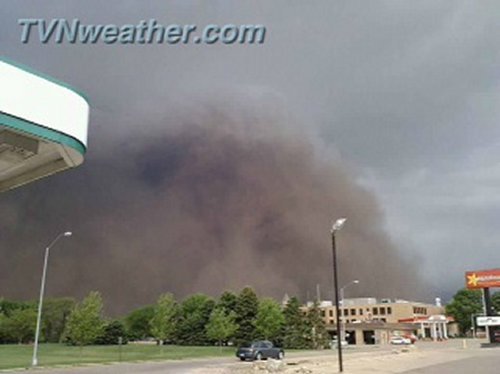
On Friday afternoon an interesting sight could be seen associated with a thunderstorm rolling across Orange City, Iowa: a haboob, also known as a dust storm, was spotted crossing the city limits as the thunderstorm arrived. The haboob is created when a downdraft of a thunderstorm is strong enough to pick up dust and sand ahead of the approaching storm. As the dust gets picked up, a haboob forms and a wall of dust can be seen reaching as high as a couple kilometers into the sky. When the thunderstorm weakens and there are no more downdrafts, the haboob will either just settle or will become a “mud storm” if there is still rain falling that will combine with the dust particles.
The best storm dynamics will stay in the High Plains for the beginning of the weekend, slowly shifting south and east as the weekend rolls along.