Elsewhere in Weather News: June 2nd, 2012

Flooding Returns to China

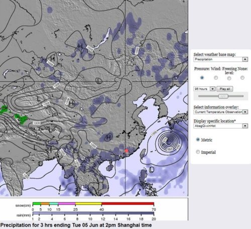
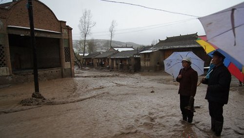
Another round of flooding in China left locals in the province of Guangdong scrambling for higher grounds this past week as floodwaters rose and swept away homes. As opposed to the flooding in north-western China featured in the May 12th post, this flooding took place in the south-east regions about 200km north of Hong Kong and was associated with a low pressure system.

Flooding

Roads turn into rivers as heavy rains fall in Meizhou, Guangdong. (Source: Euro News)

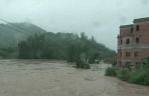
The large city of Meizhou, Guangdong, was caught in the middle of one the most severe floods this year. Some 210,000 residents living in the city were affected and 25,500 had to be evacuated from terrain that is prone to landslides and flooding, prior to these heavy rainfalls. As torrential rains fell, landslides took out more than 1,000 houses and the extensive rains caused over 4,000 hectares of farmland to be lost. In addition to that, six people lost their lives in the floods. The government has estimated the financial tally to be over 30 million dollars, taking in consideration damaged crops and infrastructure as well as services used to fight against the floods.

This rain is the last thing China needs this year, as widespread flooding has been occurring throughout the country. Areas at risk have included the north-west earlier this May, the south-east this past week and coming week. Also, currently, in the central region of China, crews are already prepping dikes since rivers are expected to overflow their banks in the coming summer months. The latter threat is due to saturated grounds combined with forecast medium-range models suggesting one and a half times average rainfall – China’s Ministry of Water Resources are on high alert.

Forecast rainfall

Map showing more rainfall expected in Meizhou next Tuesday morning. (approximate location of Meizhou with red circle, rain in shades of grey). Rain was not only expected on Tuesday but also Monday and Wednesday. (Source: weather-forecast.com)

Elsewhere in Weather News: May 26th, 2012

Already an Active 2012 Hurricane Season

The first major hurricane of the year for the Eastern Pacific Ocean spun up on May 22 to the south-west of Mexico and will likely make landfall on the west coast. As of Friday afternoon, Hurricane Bud was cruising along at a northerly trajectory as a category one hurricane, packing winds of 120km/h in its core and releasing very heavy rains within its spiral banding.

Hurricane Bud Friday afternoon

Infrared satellite picture of Bud near Mexico’s coast on Friday afternoon. (Source: NOAA)

Bud is forecast to decrease slightly in intensity as it hits the mountainous regions of Mexico’s west coast and interacts with the dry air to its north. However, Bud is still predicted to bring winds from 90km/h to 110km/h, as it makes landfall just to the south-west of Puerto Vallarta, between a weak category one hurricane and strong tropical storm status.

Bud's track

Bud’s track and coastal warnings; in blue a hurricane warning, in red a tropical storm warning, in pink a tropical storm watch. (Source: HEWS/NHC)

The worrisome part of this storm, however, is not the winds that accompany Bud, but the rainfall associated with it. From 150mm to 200mm are expected to fall with even higher amounts locally along the coast. As it makes landfall on the hilly coast, mudslides are a big threat to towns in the vicinity. A hurricane warning has been issued for a small part of the Mexican coast that is sparsely populated in the area where Bud’s centre will make landfall.

Interesting facts on Bud:

  • Bud is the strongest hurricane ever recorded in the Eastern Pacific this early in the year; it reached category three (185km/h) late Thursday night.
  • Only 12 hurricanes have been recorded in the Eastern Pacific in May since 1949, Bud is one of them.
  • Two meter high waves were already experienced on the Mexican coast Friday afternoon ahead of Bud.

Mexico officials say they are ready for Bud; they have cancelled schools in 11 municipalities for Friday and have 15,000 spots ready in rescue shelters if evacuations are needed. Bud will reach land on Friday night and slowly curve back out to the Pacific as a tropical depression by the end of the weekend.

The hurricane season in the Eastern Pacific officially started May 15th and it has already been very eventful at its outset with two named storms. In the Atlantic, where the season officially kicks off on June 1st, an area of low pressure is already forming off the coast of Georgia and has a very good shot of becoming a subtropical/tropical storm by this weekend. So, lots to keep an eye on during this active start to this year’s hurricane season as there will certainly be more to come!

Low off the east coast

Possible tropical storm forming off the east coast in infrared satellite. (Source: NOAA)

Elsewhere in Weather News: May 19th, 2012

Strong Winds, Wildfires Rage On

South-eastern Manitoba has seen its fair share of fires burning this spring but it wasn’t comparable to the conditions experienced this past week in Arizona and Colorado where wildfires are burning out of control across the states. Fanned by very strong southwesterly winds associated with a ridge of high pressure that is strengthening over the west coast, the fires quickly grew out of control in Arizona. Wind gusts of 80km/h were recorded in the area which easily spread the flames and expanded the fire by blowing embers, making it nearly impossible for firefighters to contain the blazes. In addition to the strong winds, both states have been impacted by severe droughts this month; especially Arizona where soil moisture content is bone dry.

Fire map

Map showing in red where the largest fires are. (Map provided by Google Maps.)

As of Friday morning, one dangerous fire was burning in north-eastern Colorado; a couple in the Tonto National Forest just north-east of Phoenix, Arizona; and other smaller fires had flared up in New Mexico and Utah.

As for the Colorado fire, conditions will improve slightly as thundershowers are in the forecast and will bring rain however cloud-to-ground lightning from the storm could potentially spark more fires. The Colorado fire was 11% contained as of Friday afternoon; it consumed more than seven thousand acres and has forced a couple dozen people out of their homes.

Colorado wildfire

Image of the large Colorado fire burning just west of Fort Collins. (Source: Denver Post)

For the Arizona fire it’s a different story though – as a big ridge builds over the region, relative humidity will continue to drop dramatically, reaching values in the low teens to single digits. This, combined with extremely hot temperatures of around 40°C, will surely cause hardship and less than ideal conditions for firefighters as they work feverishly to battle the flames. The Arizona fire was 5% contained and 80 homeowners were on alert to get ready to leave on Friday afternoon. With the tinder-dry conditions persisting in the area for the next couple of days, residents must pay attention to every slight fire danger they may pose during everyday activities –whether it’s having a barbeque or using their ATV in the wilderness.

Arizona wildfire

Cloud of smoke coming from the couple wildfires in Arizona’s Tonto National Forest. (Source: MSNBC)

Elsewhere in Weather News: May 12th, 2012

China Gets Battered by Torrential Rains

On the afternoon of Thursday May 10th, the north-west part of China (province of Gansu) saw severe thunderstorms roll through its higher elevations and bring with them dangerous hail and downpours that wreaked havoc across the region. With heavy rains being the most threatening hazard in this part of the country because of the mountains and easily-triggered mudslides, around 3,000 residents were evacuated for precautionary measures in the areas most prone to flooding.

Residents evacuating

After heavy rains fell many residents had to be evacuated or rescued as roads were blocked off. (Source: Shanghai Daily)

As the large hail and heavy rain fell, the Minxian County in the province of Gansu was hit the hardest when 70mm of rain fell in about an hour. Mudslides and large hail impacted the county significantly as they destroyed 7,000 acres of farm fields, closed roads leading in and out of the county including a large interstate, and damaged more than 30,000 houses. The mudslides also sent 40 people to hospital, killed 37 others, and the toll may rise as over 20 other residents are still missing. In total, 17 of the 18 townships in the region were affected – this comprises of one fifth of the county’s entire population. China’s flood control headquarters issued more warnings in the same regions on Friday in an effort to raise awareness about the dangers of flash floods and the need to prepare for another possible bout of heavy rains again this weekend. The Red Cross chipped in by donating quilts and coats to the now homeless, and Chinese government pledged $320,000 to fix damaged schools, hospitals and water treatment plants.

Torrential rains

Roads become small creeks as torrential rains fall in the province of Gansu, China. (Source: China.org.cn)

About 3,000 first response workers, still battling with Mother Nature’s wrath, worked fervently around the clock on Friday evening, one day after the storms struck, to find those still missing.