A weakening disturbance will push through the province today, bringing some rain to the region. As it clears out, the heat and humidity will build back in for week's end sending daytime highs back towards the 30°C mark.
Today will see Winnipeg stuck under overcast skies as a disturbance rolls through the region, bringing some showers to the region. The best chance for precipitation will begin mid- to late-morning through the early afternoon, with diminishing chances later in the afternoon as the system moves out of the region. The cloud cover and shower activity will keep things a bit cooler with daytime highs near 21°C.
Skies will clear in the evening as the disturbance departs the region and temperatures will fall to a low near 12°C. Thursday will be a beautiful sunny day across the Red River Valley with a high near 24°C and light winds. Temperatures will dip to around 14°C on Saturday night with just a few clouds.
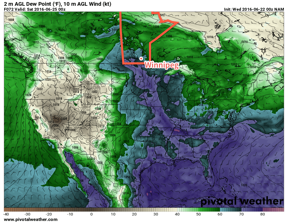
A plume of higher dewpoints, shown by the blue and purple colours, is forecast to move into southern Mantioba on Friday. A weakening disturbance will push through the province today, bringing some rain to the region. As it clears out, the heat and humidity will build back in for week’s end sending daytime highs back towards the 30°C mark.
Friday will see a return of the heat and humidity as a southerly flow re-develops over the Red River Valley. Winds will strengthen to around 30 km/h out of the south ahead of a major developing weather system in the western Prairies. Temperatures will climb to the upper 20's in the afternoon with a few clouds moving into the image. Perhaps more notably will be the humidity, which will surface through the day after northwards transport on Thursday night. From a relatively comfortable dewpoint of 12-13°C in the morning, by the end of the day the dewpoint will climb into the 18-20°C range, making for quite a muggy afternoon.
Heading into Friday evening, more cloud will move into the Red River Valley with a risk of showers or thunderstorms. It's early at this point, but there may be a slight risk of severe thunderstorms throughout the Red River Valley, including Winnipeg, on Friday evening.
Long Range
Saturday will be a warm and very humid day that will likely bring mixed skies and the risk of thunderstorms. Sunday looks to be much cooler with more comfortable humidity with a continued chance of showers or thundershowers as a large upper low moves over the province.
Winnipeg’s seasonal daytime high is currently 24°C while the seasonal overnight low is 12°C.
This week will start out on a drier note after the heavy rains of the weekend left many parts of southern Manitoba in a very soggy state.
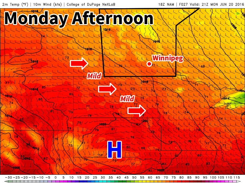
Mild and breezy weather is expected in southern Manitoba on Monday
This Week
Today will be mainly sunny with temperatures climbing into the low twenties. The sunshine will be welcomed by many in southern Manitoba as it will give a chance for many water logged areas to dry out. Winds will be northwesterly at 20-30 km/h.
Tuesday will feature much the same weather as today, with temperatures in the low twenties and mainly sunny skies. Winds will be a bit lighter however, making it an even better day.
Wednesday’s weather is the most uncertain of the early week period. Most models suggest southern Manitoba will see mainly sunny conditions with temperatures in the mid twenties. However, an area of precipitation is expected to pass to our south. Should the forecast shift that precipitation northward, we could see more rain. At this time that does not appear likely, but it is something to bear in mind.
Long Range
The long range forecast continues to show us in a generally above-seasonal pattern through the end of June. However, we are also forecast to remain near the storm track through month’s end, suggesting more wet weather may be on the way later this month. Forecasting weather in the long range can be quite difficult in summer, so unfortunately you’ll just have to take the conditions as they come to some extent.
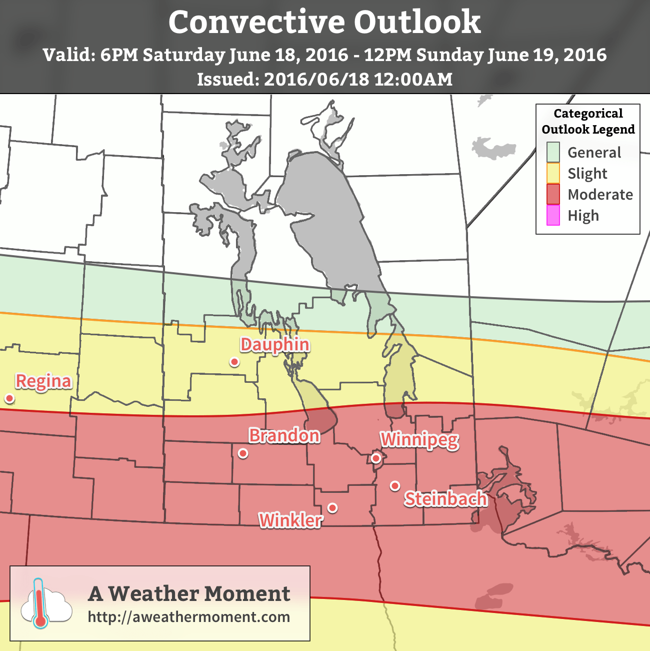
Sunday, June 19th marks both Father’s Day as well as the Manitoba Marathon, and unfortunately it appears that the unsettled weather we talked about in Friday’s post has the potential to bring a significant threat of severe thunderstorms to the region.
AWM Convective Outlook for June 18/19, 2016
The Short Version
Severe thunderstorms are possible early Sunday morning, however that threat will be conditional on the expected development of thunderstorms in Saskatchewan on Saturday night.
The current expectation is that an area of thunderstorms will develop over Saskatchewan Saturday night, expanding in coverage and accelerating eastwards through the overnight period. This area of convection will then move through the Red River Valley with a primary threat of severe and damaging winds as well as large hail and torrential rain capable of producing flash flooding.
Thunderstorm Threat Outlook for Sunday June 19, 2016
Threat Type
Threat Level
Details
Rain
Moderate
Torrential rainfall possible with flash flooding.
Hail
Moderate
2-4cm hail possible.
Wind
Moderate
Strong wind gusts in excess of 100 km/h likely
Tornado
Low
No tornado activity expected.
The thunderstorm activity is expected to occur between 4:00AM and 9:00AM, with the primary threat period between 5:00AM and 7:00AM. The timing may adjust depending on the exact speed of the system, but overall this is expected to be a morning event.
Forecast for the morning of June 19, 2016
6AM
8AM
10AM
12PM
17°C
19°C
21°C
23°C
Thunderstorms likely
Thunderstorm activity diminishes
Slight chance of showers
Partly cloudy
Alongside the thunderstorms, conditions will get notably more humid as the morning progresses.[1] By the time any thunderstorm or rain showers taper off, things will feel fairly sticky. Temperatures will start around the 16-17°C mark in the morning, climbing to around 23°C by noon, and then on to a high near 27°C in the afternoon. Winds will be fairly light until mid-afternoon when they pick up from the west to around 20-30 km/h, ushering in drier air and providing some relief from humidity.
The Details
The potent thunderstorm potential for Saturday night and Sunday morning across the southern Prairies will be the result of a potent shortwave that ejects northeastwards out of Montana on Saturday and then rides eastwards along the international border. This will spawn a surface low with cold front draped southwards as cooler air builds in behind the shortwave and warm front extending eastwards across the northern portions of the Northern Great Plains. The surface low will then slide eastwards, gradually lifting the warm front northwards as it goes.
This shortwave will [likely] initiate an area of convection over southwestern Saskatchewan that will track eastwards along with the shortwave. The orientation of the warm front will provide plenty of support for the convection with shear profiles that indicate the likely development of a MCS[2] containing bow echoes.
Going over the MIST ingredients:
Moisture: Dewpoint values near 18°C will be ingested into the convection on Saturday night. This will provide substantial energy for the thunderstorms to work with. Additionally, the high moisture content of the air being ingested will increase PWAT[3] values to over 50 mm, making very intense rainfall likely with any thunderstorms that develop.
Instability: Steep mid-level lapse rates will combine with the warm and humid air of the nocturnal inflow to produce MUCAPE values in excess of 2000 J/kg.
Shear: 55-65 kt of bulk shear coupled with veering profiles within the convection will support the development of strong, organized thunderstorms.
Trigger: Shortwave-induced mid-level destabilization coupled with the development of a strong LLJ.
For these parameters, the primary concerns will be hail and rain, however should the storms be able to break through the inversion, wind will rapidly become a significant threat as gusts in excess of 100 km/h will be possible.
The steep mid-level lapse rates combined with high MUCAPE values will produce a moderate hail threat with hail between 2-4 cm in diameter possible. The heightened PWAT values make torrential rain likely with these storms, which can result in rapid accumulations and flash flooding. The strong winds & shear profiles of the storm environment make damaging wind gusts possible. Justification for the strong winds despite the nocturnal part of the convection will be the intense storm-relative winds that will be associated with this quickly-moving system. The SR-inflow will likely be strong enough lift the low-level air mass wholesale into the storm, resulting in a surface-based or near-surface-based thunderstorm.
Summary
Father’s Day of 2016, and the Manitoba Marathon, face the potential of being remembered for severe thunderstorms if current guidance continues painting the picture it does. Thunderstorm potential is conditional on nocturnal convection developing on Saturday night in Saskatchewan, but if it does, there is a significant threat of severe thunderstorms over Southern Manitoba on Sunday morning.
The timing for the primary severe thunderstorm threat will be in the early morning, buffering the starting time for the marathon, with much of the thunderstorm activity expected to be out of the region by 10-11AM. In the wake of this system will be a warm day that will feel fairly humid until westerly winds kick in mid-afternoon, pushing out the humidity and drawing in drier, slightly cooler air for the start of next week.
Dewpoint temperatures are expected to rise from 12-13°C early in the morning to around 19°C by mid-morning. ↩
Unsettled weather will continue through the weekend as multiple disturbances ripple across Southern Manitoba, bringing mixed skies alongside a few chances for rain.
Yet another round of nocturnal convection1 will roll through this morning just ahead of a weak cold front slowly pushing eastwards across the Red River Valley. As of writing this2 there is still some uncertainty as to how extensive the convection will become, but best indications are that we could see a few showers or thundershowers early this morning as a more intense area of convection passes to the south. After that, Winnipeg & the Red River Valley should see clearing skies through the morning, especially once the "cold" front moves through.
Behind the cold front, westerly winds will ease the humidity that has built into the region over the past two days as dew points drop from the upper teens back towards the 10°C mark. With drier weather and sunny skies, temperatures should climb to a high near 27 or 28°C throughout the Red River Valley with winds up to 20-30km/h out of the west-northwest. Expect partly cloudy skies overnight with a low near 15°C.
Saturday will bring more cloud to the region as mixed skies develop through the morning with a chance of some light shower activity through the Red River Valley. Things should clear out by the evening, and the late day sun should push us to a high near 26°C.
While models keep the bulk of precipitation to our south on Saturday, a few light showers are possible thorugh the Red River Valley.
Winds will shift back around to the south late in the day, beginning to bring more humid air back into the region; with dew points expected to rise back into the mid-teens overnight, overnight lows will be kept fairly warm at around 17°C. We'll see a few clouds overnight.
Sunday will see yet another disturbance move through the region bringing another chance of showers or thunderstorms. The main threat for precipitation will occur through the morning hours, followed by skies becoming mixed in the afternoon. Daytime highs should be around 26 or 27°C with muggy conditions in place much of the day as dew point values hover around 17°C. As skies clear, gusty winds will pick up out of the west to around 30 km/h.
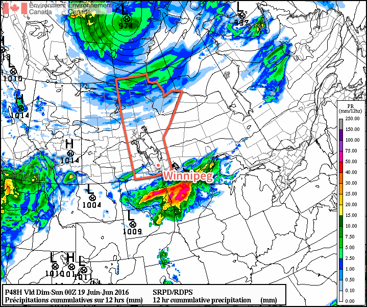
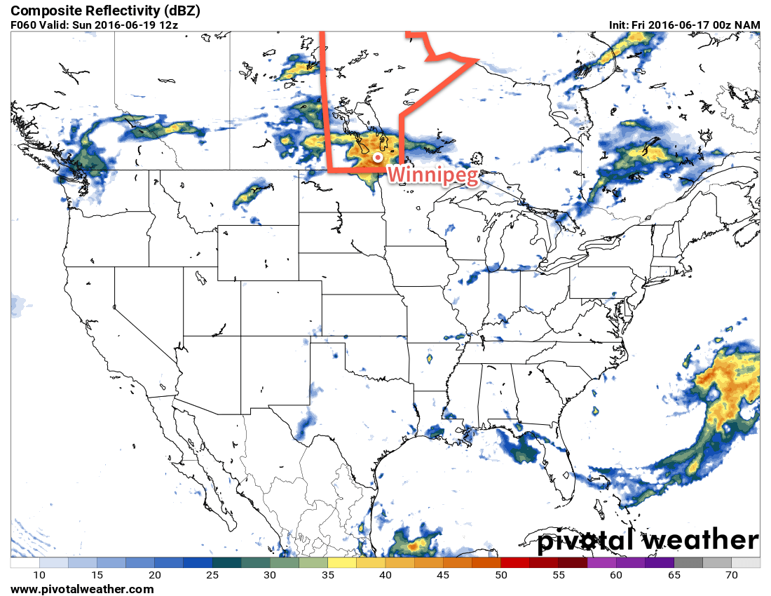
This simulated RADAR image from the NAM shows a large area of convective rainfall moving through the Red River Valley on Sunday.
Drier air will push in Sunday evening, helping overnight lows dip to a cooler 13°C or so with just a few clouds.
Long Range
Unfortunately, things don't look much better to start off next week. Another round of showers are possible late Monday through the overnight period as a disturbance slumps through from the northwest. Afterwards, though, it looks like we might see a few dry days with daytime highs ranging from the low 20's to the upper 20's.
Nocturnal convection is the term applied to thunderstorms that persist through the overnight period. They are different from typical thunderstorms in that they get their heat and moisture from features detached from the ground. ↩