Another Brief Shot of Winter Ahead for Winnipeg

Saturday will bring another day of seasonably mild weather in Winnipeg, but a cold front sweeping through the province will usher in colder weather for Sunday.

RDPS 2m Temperature Forecast valid 15Z Monday November 27, 2023
A colder air mass will settle over the eastern Prairies by Sunday night.

Temperatures will climb near the freezing mark again today in Winnipeg as warmer air floods into the southern Prairies. The region will see mixed skies today and winds will persist out of the southwest in the 20 to 30 km/h range.

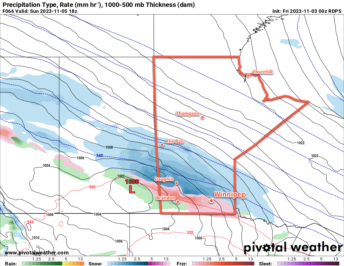
There will be a notable change in the weather this evening. A low pressure system moving through central Manitoba will sweep a cold front across the province overnight. The front will bring a band of snow that pushes from Parkland Manitoba this early into the Red River Valley before midnight, then to the Ontario border by Sunday morning. Behind the front, moderate northwest winds up to 40 gusting 60 km/h will usher a colder air mass into the region. A few flurries may linger across the region overnight behind the front. Temperatures will fall to a low in the -5 to -10 °C range.

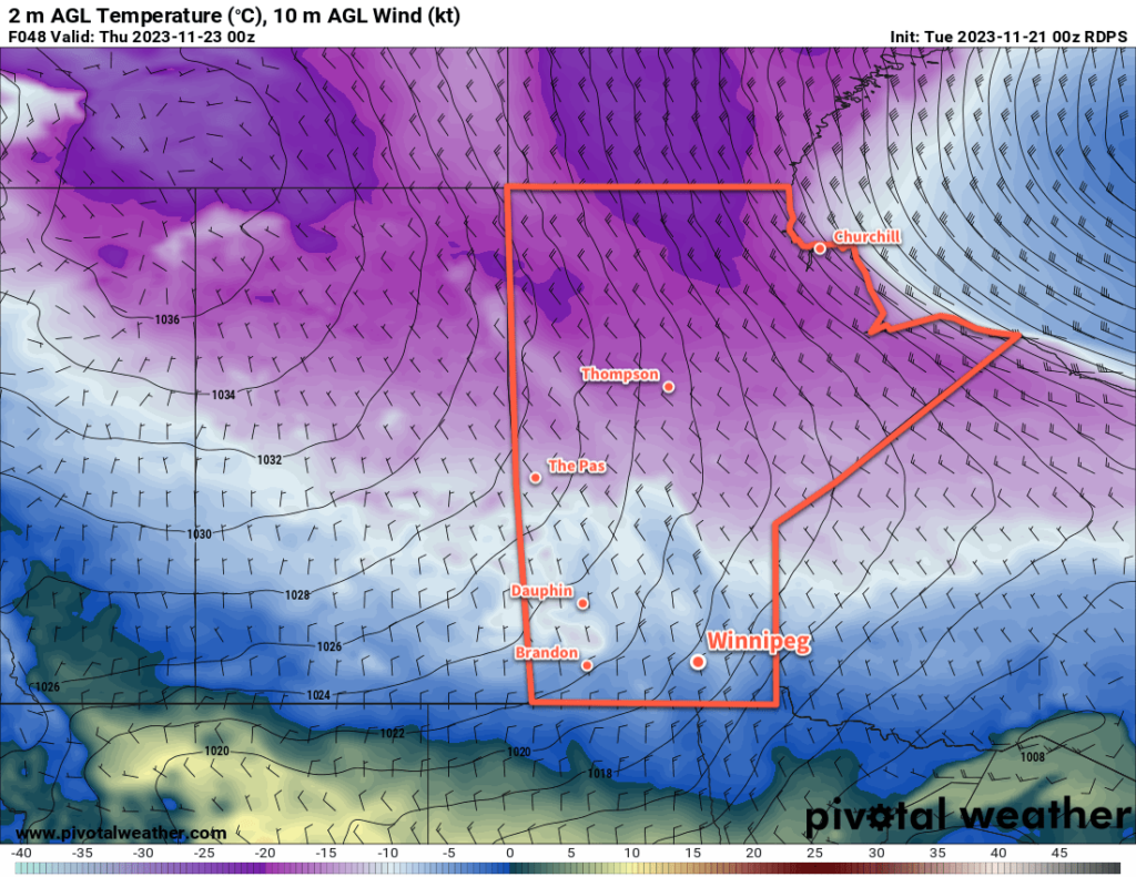
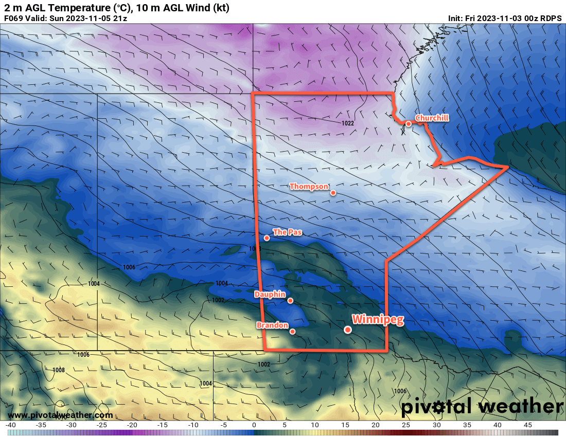
On Sunday, the northwest winds will continue across the region as temperatures continue to fall through the day. Skies will clear by the afternoon with temperatures dropping into the -10 to -15 °C range. With clear skies and winds diminishing, temperatures will drop further into the -15 to -20 °C range on Sunday night.

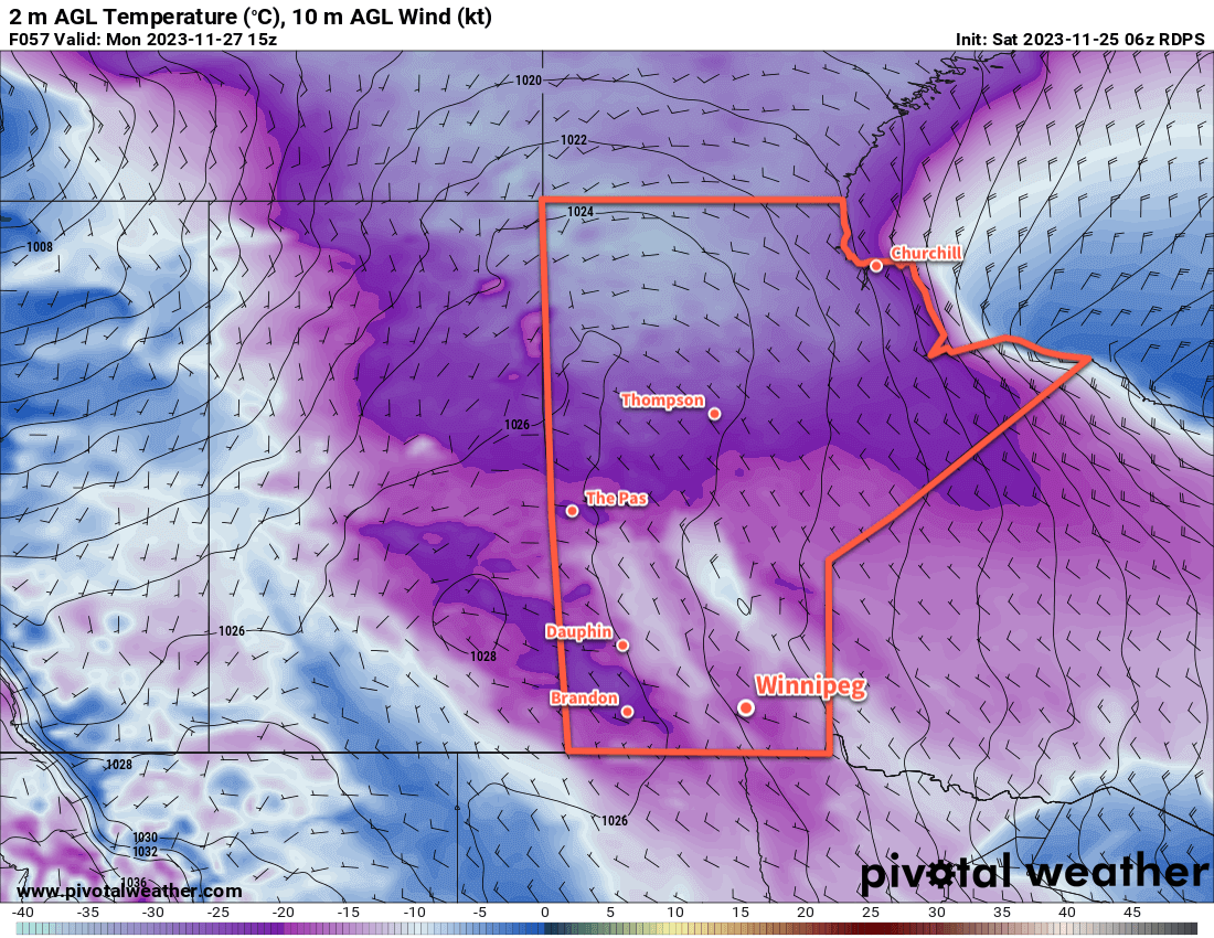
The cool temperatures will continue on Monday with sunny skies and a high in the -5 to -10 °C range. On Monday evening, a warm front will push eastwards across Manitoba, bringing some more snow as a milder Pacific air mass pushes back into the province.

Long Range Outlook

We could see some snow in the Red River Valley early Tuesday, but much of the snow should fall to the north and east. Temperatures will rebound into the -5 to 0 °C range for Tuesday afternoon.

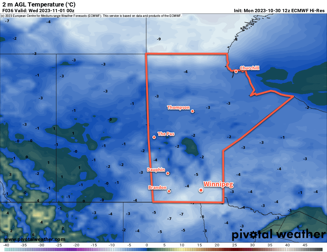
The region should be another day with above-seasonal temperatures on Wednesday, then a return to seasonal values for the rest of the week.

Today’s seasonal daytime high in Winnipeg is -5 °C while the seasonal overnight low is -14 °C.

Colder Weather to Push Into Southern Manitoba

There will be a shift in the weather across southern Manitoba this week as a cold front sweeps through the region and ushers in wintery temperatures. The cold snap will be short-lived, though, with a relatively quick return to near-seasonal conditions.

RDPS 2m Temperature Forecast valid 00Z Thursday November 23, 2023
An Arctic high will begin pushing into the Prairies on Wednesday night and allow colder air to spill southwards through the region.

After a rather busy period over the last few weeks, it’s nice to be back with some time to forecast. I hope you’ve all been able to enjoy the pleasant extended warmth so far this November. The cold weather will come eventually, so it’s nice to keep it at bay as long as possible late into the year.

Heading through the rest of the week, the main weather system will be a clipper-like system that tracks across the southern Prairies on Tuesday night into Wednesday. Daytime highs will continue to sit around 0 °C or a bit warmer as northwest winds taper off and shift to light southerlies. Winnipeg will see plenty of sun today, but some cloud will move in tonight and stick around into Wednesday morning.

A cold front will sweep through the region later on Wednesday, ushering in moderate northwest winds of 30 to 40 km/h. Skies will clear out with the winds and temperatures will begin to drop. An Arctic high will slump into the region, bringing much cooler weather with it.

For the second half of the week, overnight lows will dip into the minus teens; likely into the -15 to -20 °C range Wednesday and Thursday night, and then moderating into the -10 to -15 °C range for Friday night. Daytime highs will also follow suit, dipping into the -5 to -10 °C range.

Long Range Outlook

A disturbance will move into the region on the weekend, bringing some cloud and a chance for some light snow as well. With the cloud will come temperatures that moderate back towards seasonal values, dipping slightly cooler at times.

Today’s seasonal daytime high in Winnipeg is -4 °C while the seasonal overnight low is -12 °C.

Wintery Mix of Snow, Freezing Rain, and Rain Possible on Sunday in Southern Manitoba

A slow-changing weather pattern over Winnipeg will continue to bring daytime highs near the freezing mark and mixed to cloudy skies. By Sunday, though, an approaching low could bring a wintery mix of snow, rain, and freezing rain to southern Manitoba.

RDPS 2m Temperature Forecast valid 21Z Sunday November 5, 2023
Temperatures will hover near or above the freezing mark over the next few days.

Today will start with some cloud moving through the Red River Valley as a weak front slumps into the region. In its wake, light northerly winds will accompany clearing skies. Some cloud will persist through the day as lake-effect flurries stream off lakes Manitoba and Winnipeg, but the wind direction should favour them flanking Winnipeg rather than moving through the city.

Temperatures will climb up to a high around 0 °C today, then dip to a low in the -5 to -10 °C range tonight.

Heading into the weekend, warmer air will attempt to build into the region. Rather than seeing any notable warm-up, as it often is this time of year, the region instead will be blanketed in cloud. Winds will shift southerly and ease further on Saturday with cloudy skies in the Red River Valley. The remnants of a collapsing low pressure system could bring some light snow to the region on Saturday afternoon.

On Saturday night, a low pressure system developing in Alberta will eject eastwards across Saskatchewan. Winds in the Red River Valley will shift eastwards overnight in response along with a low chance of some light snow. Temperatures will only drop a few degrees from Saturday’s daytime high.

On Sunday, a wintery mix of precipitation will push into Manitoba ahead of the approaching low in Saskatchewan. The day will likely start with some rain and/or freezing rain spreading through southern Manitoba while snow pushes through the Parkland into the Interlake. As the day progresses, the freezing rain will diminish while the rain/snow line lifts northwards. Daytime highs should reach around +2 °C on Sunday afternoon.

RDPS Forecast Precipitation Type/Rate valid 18Z Sunday November 5, 2023
Southern Manitoba may see a wintery mix of precipitation on Sunday, including freezing rain.

By the end of the day, the low centre will cross through the Red River Valley, followed by northerly winds and the rain/snow line collapsing southwards as the precipitation tapers off overnight. The freezing rain potential in southern Manitoba will largely be confined to the morning, and while conditions could be poor while it’s occurring, the subsequent climb above freezing with temperatures should limit the longevity of its impact. If you have plans to travel on Sunday morning, be prepared for adverse travel conditions and be sure to check highway conditions before leaving.

Long Range Outlook

Temperatures will stay comparatively mild next week with daytime highs likely creeping to the positive side of freezing through the week. Some flurries will be possible, but the next organized precipitation event will likely be with a low pressure complex moving through the region mid-week.

This system could bring another wintery mix of precipitation to southern Manitoba as it passes through.

Don’t expect to see the sun too much; skies will be mainly cloudy this week. Some more organized sunshine could begin to move back into the region in the latter half of the week.

Today’s seasonal daytime high in Winnipeg is +3 °C while the seasonal overnight low is -6 °C.

Cool Weather Continues in Winnipeg

A stagnant weather pattern will continue to funnel Arctic air southwards into the Prairies, continuing the cool temperatures across southern Manitoba.

ECMWF 2m Temperature Forecast valid 00Z Wednesday November 1, 2023.
It will be a cool night across southern Manitoba as a ridge of high pressure slides through the region.

A slow-moving vortex over Hudson Bay continues to support an outbreak of Arctic air across the eastern Prairies this week. Between this system and a high-amplitude upper ridge over the west coast, northerly winds through the region will be maintained for a few more days yet.

As a result, temperatures will stay stuck below seasonal values. Today will be the coldest day of the week, the cold air bolstered by the passage of a disturbance yesterday. The high in Winnipeg should reach around -6 °C with temperatures dipping to about -8 to -10 °C by the time kids start heading out to prowl the neighbourhoods for Halloween.

Heading through the rest of the work week, the city will see daytime highs close to the freezing mark and overnight lows dipping into the -5 to -10 °C range. Skies will be mixed over the coming days and winds, aside from a bit of a breeze this evening, will be light.

No notable snowfall is expected, but a few light flurries could be possible through the week.

Long Range Outlook

Little change is expected to the pattern beyond weakening slightly in the days ahead. This will mean that daytime highs should continue to hover at or just below freezing into next week along with overnight lows dipping below -5 °C.

There are some early indications that some snow may be possible early next week; we’ll continue to keep an eye on that system as it develops.

Today’s seasonal daytime high in Winnipeg is 4 °C while the seasonal overnight low is -5 °C.