Remember Winter?

Expected precipitation types on Saturday.

Supplications for summer will be silenced as the stage is set for a sloppy spring storm that will supply snow to Southern Manitoba. Two disturbances will impact the region – one this morning and the other tonight through Saturday – and bring decidedly messy spring-time weather to the region followed by a surprisingly cold air mass for mid-April. Get those snow shovels out and read on to find out what to expect in your area.

Disturbance #1

The leading disturbance moving through the province this morning is by far the weaker of the two and will move through quite quickly. Disorganized showers or flurries are possible across the region through the morning hours, then we’ll see the clouds begin to clear out giving some sun for the afternoon. We’ll reach a high of only around +4°C today with light northeasterly winds.

Friday
4°C / -3°C
Cloudy periods. Slight chance of morning flurries or showers.
Saturday
1°C / -8°C
Snow. 5-10cm.
Sunday
-2°C / -14°C
Mainly sunny.

Disturbance #2

Our reprieve from the snow threat will be short-lived, however, as another system pushes into Southern Manitoba tonight. Cloud will stream into the Red River Valley this evening ahead of the main precipitation associated with this low, which will not push into the RRV until the second half of the overnight period. Temperatures will drop to only around -3 or -4°C overnight.

As the precipitation shield undergoes rapid expansion early in the evening, snow, heavy at times, will fall along and south of the Trans-Canada Highway in southwestern Manitoba through a good portion of the night which will result in some of the highest accumulations for this storm. By the time all is said and done, 10-20cm of snow is possible over southwest Manitoba.

Further east in the Red River Valley, snow will push in much later in the overnight period, first spreading into the Morden/Winkler region and then pushing northeastwards. Snow will reach Winnipeg by early Saturday morning. The heaviest snow will fall in the southern portion of the RRV with enhanced amounts possible in the southwest corner near the escarpment where upslope winds will help enhance snowfall.

The main snowfall event for the Red River Valley will occur through the day on Saturday. Weak warm advection aloft will do little to help temperatures at the surface which will be stuck out of the north feeding cooler, dryer air into this system. Coupled with the snow, temperatures through the valley won’t climb much more than a degree or two above zero. It will likely be warm enough at the surface (and aloft) to melt some of the snow that falls. This will reduce snowfall amounts a bit, but given the intensity of the precipitation expected, snow accumulation should overpower the melting factor fairly quickly.

Total snowfall expected Friday night through Saturday. Amounts may be lower depending on how much melts.

In general, most areas seem to be set to see around 5-10cm of snow, perhaps a little less if there’s more melting. With temperatures near zero, it will be a somewhat wet, heavy, sloppy snow that will likely make driving very unpleasant and slippery. The snow should taper off on Saturday evening as the system pushes off to the east. Skies will clear in advance of an Arctic ridge pushing into the Prairies and we’ll drop to an overnight low near -8 or -9°C.

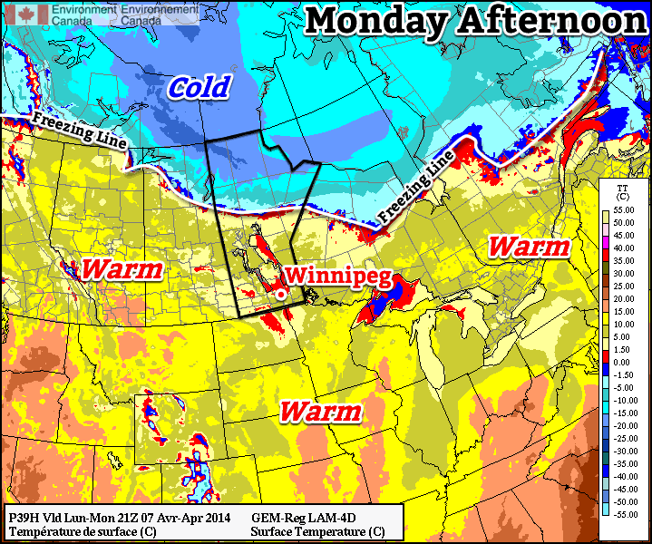
Cooler Weather Ahead

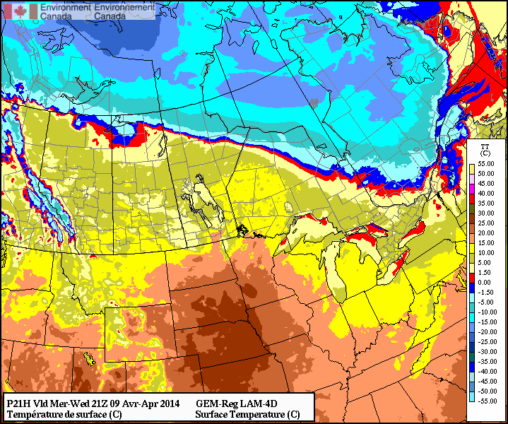
Behind this system, very cool arctic air will push into the Prairies. Sunday will be mainly sunny with some afternoon cloud but the temperature will top out more than 10°C below normal at only around -2°C.

The start of next week continues the sunny trend, although Monday will be nearly 20°C below normal with a high of only -8°C. More seasonal air looks to build back in midweek.

Springtime: Blowin’ in the Wind

The warmest day of 2014 is on tap for Winnipeg as a low pressure system tracking through the northern Prairies brings with it an unseasonably warm air mass. With the passage of a cold front today we’ll also see strong – potentially near warning level in some areas – winds that will usher in slightly cooler temperatures than we’ve seen the past few days as well as a slight chance for a shower or two. With so much snow left on the ground, however, the big question is exactly how warm will it get?

Wednesday
10°C / 0°C
Partly cloudy; windy later today.

Thursday
7°C / -3°C
Mainly sunny. Winds gradually diminsihing.

Friday
7°C / -6°C
Mainly sunny.

Today

We’re off to a great start today with temperatures already above the freezing mark thanks to the incoming mild air and relatively breezy conditions that persisted through the overnight period. Warmer air will continue to stream in through the morning hours, producing a brisk southerly wind through the valley at 30-40km/h. Temperatures will climb the best they can, but the remaining snowpack will do a lot to keep us cooler.

In order for us to reach the full potential of the warm air coming in, we need to be able to mix it down to the surface. The best way to create instability in the lower levels is the sun; it shines down and warms up the surface until it gets hot enough (assuming the sun is strong enough) to create instability and begin mixing the lower atmosphere. This mixing process can help bring warmer air down and maintain a warmer temperature. Unfortunately, snow can dramatically inhibit this process through two main ways:

  1. Snow is white, so it reflects the incoming energy from the sun back out into the sky. This prevents that energy from being put into warming up the ground or air in the low levels.
  2. Snow is frozen, so when the temperatures begin to climb above zero the snow begins to melt, removing energy from the air and cooling it off.

With no snow, all the energy from the sun can go into heating the surface. Today we’ll see a pretty big difference in temperatures between areas with snow versus areas without snow. Here in Winnipeg, temperatures will likely climb to around 9-10°C before a cold front pushes through this afternoon. In the snow-free areas of North Dakota and a few portions of the western Red River Valley, temperatures will likely climb into the mid-to-high teens, possibly as high as the low 20’s.

Foreast temperatures for this afternoon from the RDPS. Note the warmer temperatures in North Dakota (no snow) and downwind of the western escarpment of the Manitoba Red River Valley.

The abnormally warm weather will be short-lived as a cold front blasts through the province midday. Strong westerly to northwesterly winds with gusts as high as 70km/h will push into the Red River Valley this afternoon. Temperatures may actually climb a degree or two behind the cold front before they begin to drop a bit thanks to all the warm air aloft that is able to be mixed down. There will be a slight chance for a shower with the passage of the cold front, however the chances are better to the north of the Red River Valley, where the lift is stronger, and in North Dakota, where the instability is greater. We’ll head to a low of around 0°C tonight.

The Remainder of the Week

Tomorrow will be a mainly sunny day with stronger winds that will slowly diminish as the day progresses eastwards. We’ll see a high near 7°C and a low near -3°C. Friday will be another pleasant day with mainly sunny skies and relatively light winds. The high will be near 7°C and the low will drop to around -6°C as some cooler air makes a brief appearance for the weekend.

Melt to Continue

Melt weather will continue this week, giving our snowpack a well deserved beating.

Warm weather will dominate southern Canada on Monday

Monday

Monday
4°C / -5°C
Mainly Cloudy

Today will feature temperatures similar to what we saw on the weekend. Highs will be in the mid single digits, although it will be a mainly cloudy day. The wind will be relatively light and from the west or north-west.

Tuesday

Tuesday
6°C / -1°C
Mainly Cloudy

Tuesday will be very similar to Monday is many respects. Skies will once again be mainly cloudy, but with an increasing southerly wind. High temperatures will once again be in the mid single digits.

Wednesday

Wednesday
10°C / -2°C
Mix of Sun and Cloud

Wednesday looks to be one of the warmest days of the week. An approaching low pressure system will push a warm air mass into southern Manitoba, potentially sending temperatures soaring into the positive teens. Snow-free areas just to our south could be even warmer, with Grand Forks and Fargo potentially having a shot at reaching 20C for the first time this year.

Long Range

We’ll see a slight cool down after Wednesday, with temperatures on Thursday dropping back down into the single digits. Models suggest that we’ll generally see below-normal conditions through the middle of the month, but thankfully that just means temperatures will be lower than +10C, which won’t really feel that cold in general.

Warmer and Unsettled Weekend Ahead

Temperatures will finally push towards seasonal values this weekend as a warmer air mass pushes into Southern Manitoba from the Western Prairies. Daytime highs are set to climb into the mid-single digits which will bring the warmest temperatures since March 14th of this year when we managed to struggle our way to +4.0°C. Tagging alongside the milder temperatures will be unsettled conditions with multiple chances for precipitation through the next few days.

Friday

Friday
0°C / -5°C
Mainly sunny.

Today will be quite a pleasant day with mainly sunny skies and a high near 0°C. A ridge of high pressure will keep the winds light through the day as well. There may be a few cloudy periods this morning as we clean out any remnant cloud from yesterday’s system, but otherwise there should be plenty of sunshine.

Later today will see the approach of a warm front tied to a low pressure system tracking through the northern Prairies. Winds will increase out of the south to around 30km/h tonight as the warm front approaches. Thanks to the wind and some cloud pushing in later in the night, we’ll drop to only around -5°C.

Saturday

Tomorrow has the potential to be a bit of a messy start to the week. The warm front will be pushing it’s way through early in the day, bringing with it the potential for some snow or freezing rain.

Winnipeg forecast sounding for Saturday morning from the NAM.

This forecast sounding shows the development of a small layer of above-freezing air (AFL) above a below-freezing layer of air at the surface. The AFL doesn’t look very deep, so freezing rain is far from a sure thing as the balance between melting snow and reinforcement of warm air will be a delicate one dependant on how intense the precipitation is.

Saturday
7°C / -5°C
Cloudy with chance of flurries or freezing rain in the morning, then clearing.

Depending on whether or not the precipitation manages to build far enough south to reach the Red River Valley is the primary unknown; if it does reach us then there’s a chance it will fall as freezing rain instead of snow. Whatever it decides to fall out of the sky as, though, it will be fairly short-lived and confined to the morning.

After the warm front pushes through in the morning, skies will begin to clear up and the temperature will begin climbing towards a high of 6 or 7°C. Saturday will be the warmest day in Winnipeg since the temperature hit 10.3°C on November 13th last year. Winds look to be light through the day.

Temperatures will drop to around -5°C once again on Saturday night with light winds.

Sunday

Sunday
3°C / -9°C
Mainly sunny.

Sunday will be a slightly cooler albeit still pleasant day. Winds will be relatively light out of the south as we head to a high temperature of 3°C. An incoming low pressure system will spread cloud into the Red River Valley late in the day and bring a chance of some flurries through the evening and overnight periods.

All in all it will be a fairly pleasant weekend without too much wind and some mild temperatures. Aside from a few brief chances for precipitation, it might actually feel quite spring-like out there! Enjoy!