Time to Dry Out

After a soggy weekend in southern Manitoba, we’ll get a chance to dry out early this week. Temperatures will range from slightly below normal to slightly above normal for the first part of the week.

The Week Ahead

Monday
22°C / 7°C
Mainly Sunny
Tuesday
24°C / 10°C
Mainly Sunny
Wednesday
27°C / 14°C
Mainly Sunny

Today will be a dry and sunny day, a nice change from our wash-out of a weekend. Temperatures will be in the low twenties with a pleasant light and variable wind.

Tuesday looks like another nice day in southern Manitoba, with temperatures in the low to mid twenties and mainly sunny skies. The wind will be breezy and from the north-east.

Wednesday will see even warmer weather in southern Manitoba, with high temperatures in the mid to upper twenties and a gusty east wind. We may experience a risk of a thunderstorm on Wednesday as a more unstable air mass pushes north, though it’s too early to say for sure.

Long Range

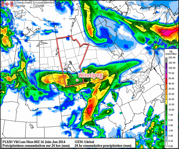
Long range models suggest that unsettled weather will return to southern Manitoba later this week. That means we’ll likely see cooler weather from late this week into next weekend. There are also hints of a hotter pattern setting up next week, but again, it’s too early to say for sure.


Summary: Heavy Rainfall Drenches Much of Southern Manitoba

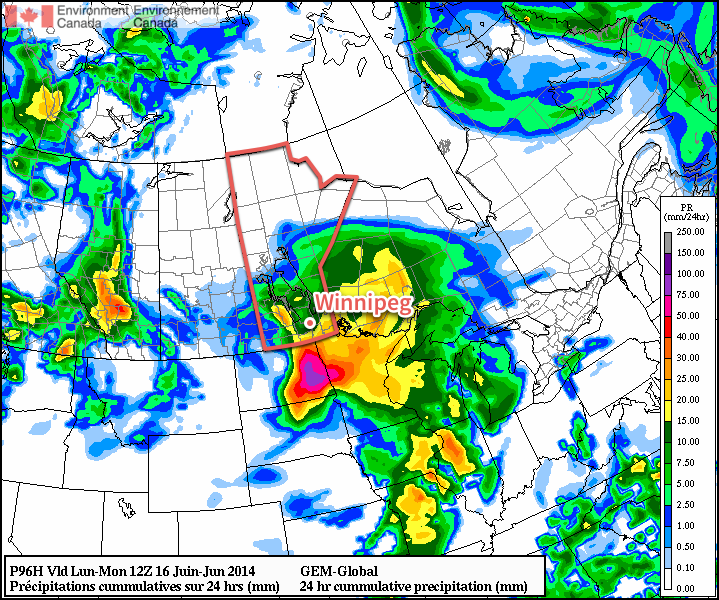
As mentioned at the beginning of the post, it was a very wet weekend across Southern Manitoba. The rain was brought to the region thanks to a stationary upper-level low pressure center that was anchored over eastern Montana. It produced a persistent southwesterly flow aloft over the province which provided both ample moisture and large amounts of lift, enabling days of showery weather. The situation worsened on Saturday night as a Colorado Low ejected north-northeastwards, pushing up towards Lake of the Woods. When the already-present lift and moisture was met with an intense system with even more moisture, the perfect recipe for heavy rain was met.

Rain begain early Sunday as showers or drizzle in many places and gradually worsened into moderate to heavy rain. The event lasted over 20 hours before things finally tapered off.

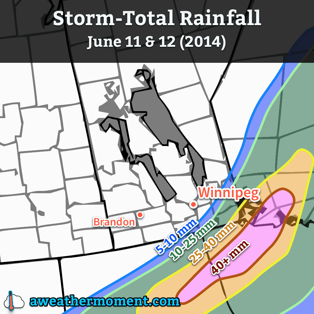
The situation was worsened in many regions thanks to the rain that fell on Saturday, however. Mid-day, a very narrow band of showers set up along a SW to NE line from Winnipeg to Beausejour and onwards to the northeast. Anywhere from 20-50mm fell in this line. It’s important to note how narrow this band was; in Winnipeg, although the airport and areas to the east-northeast through Transcona saw nearly an inch of rain from the shower activity, the southern half of the city saw less than 10mm. For the areas that saw the heavier shower activity, it did much to bolster the 2-day rainfall totals.

So without further ado, here are the rainfall totals across the region:

2-Day Rainfall Totals in Southern Manitoba
(June 14-15, 2014)
Location 2-Day Rainfall (mm)
Lockport (via CoCoRaHs) 117
Beausejour (via CoCoRaHs) 89
Winnipeg – The Forks 71.8
Pinawa 71.5
Winnipeg – Airport 69.4
Great Falls 60
Portage la Prairie 48.3
Emerson 45.6
Fisher Branch 41.1
Carman 38.8
Swan River 35.8
Deerwood 35.6
Wilson Creek 33.9
Sprague 31.5
Gimli 28.7
Roblin 25.5
Dauphin 25.3
Grand Rapids 25

Unsettled Weekend Ahead; Soggy Sunday?

Southern Manitoba will be under the influence of a complex low pressure system this weekend that will spread multiple bands of precipitation across the province. Things are a little uncertain for Sunday – Father’s Day and the Manitoba Marathon – but it’s looking probable that it may be quite wet.

Friday
21°C / 12°C
Increasing cloud; chance of afternoon showers. 5-10mm of rain overnight.

Saturday
18°C / 14°C
Cloudy; some light rain or drizzle possible.

Sunday
18°C / 10°C
Rain likely; up to 20mm.

Today will be a relatively nice day. Cloud coverage will gradually increase and there will be a slight chance of showers in the Red River Valley this afternoon as rain spreads eastwards across southern Manitoba. The temperature will climb to around 21°C.

Showers will move into the Red River Valley through the evening with around 5-10mm falling. While there may be an odd rumble of thunder, overall the thunderstorm threat is low to non-existent. Rain will move from southwest to northeast and lift into the Interlake region, leaving us with overcast skies by morning. The low temperature will sit near 12°C.

Total expected rainfall for the first wave of rain today through tonight into Saturday morning.

Saturday will be a mainly cloudy day with some showers or drizzle likely. It doesn’t look too wet, but overall it will be sort of a dreary day with sporadic precipitation. Further north, through the Parkland region eastward into the Interlake, there will likely be rain for much of the day. The high temperature will be near 18°C and expect the temperature to drop to around 14°C on Saturday night.

Uncertain Sunday

Sunday, which marks Father’s Day and the ever-popular Manitoba Marathon, has a little more uncertainty associated with it. The general weather picture shows a stalled out low pressure system over SE Saskatchewan and SW Manitoba while a Colorado low lifts northwards through the Dakotas. The evolution of the feature is very complicated, and small changes in the upper-level flow could mean big changes to the expected weather over Southern Manitoba. I’ll give the most likely solution right now, and leave updates in the comments below if it looks like an alternate solution becomes more plausible.

The GDPS is forecasting a very wet Sunday with 10-20mm of rain through many areas of Southern Manitoba.

Sunday morning will provide a cloudy start to the marathon with some scattered showers or drizzle about. The temperature should be around 15°C. By mid-day, more concentrated shower activity will push northwards through the Red River Valley, with an area of rain covering much of southern Manitoba (save for locations near the Saskatchewan border) by early-to-mid afternoon.

The rain will persist into the evening and taper off by Monday morning. Total rainfall amounts are quite variable, but overall it seems like 10-25mm is possible in most regions, with higher amounts near the US border through SE Manitoba and along the western escarpment of the Red River Vally northwards into the Riding Mountains. Anywhere from 25-40mm seems possible in these areas.

The temperature will drop to around 10°C on Sunday night after the rain tapers off.

Unsettled Pattern Continues

Next week is looking fairly unsettled as yet another major disturbance takes up residence on the Prairies. In general, more cloud than sun will be seen through the week. Heavy rainfall will set up in Alberta on Monday, and as the system develops it looks like a large area of convection will develop across the Northern Plains and lift northwards into the southern Prairies, including Winnipeg and the Red River Valley, by mid-week.

It’s a long ways off, though, so we’ll take a closer look later in the weekend when things become a little more clear.

Rain Brushes Southern Manitoba

A powerful low pressure system drenching North Dakota and Minnesota will brush the southeastern portion of the province today. For the rest of us, fairly quiet weather will prevail with slightly below-normal temperatures.

Wednesday
17°C / 8°C
Mainly cloudy. Outside chance of some light showers.

Thursday
18°C / 6°C
Mainly sunny.

Friday
23°C / 13°C
Sunny, then increasing cloud late in the day.

The main weather story today will be the low pressure system working its way through North Dakota and Minnesota. Although this system will spread cloud through the entirety of the Red River Valley, rainfall will be constricted to the southeastern portion of the Red River Valley into SE Manitoba. At this point, it looks like the main area of rain will remain south and east of Steinbach. There’s a slight chance of showers backing into Winnipeg and the SW Red River Valley (Altona, Winkler), but if any precipitation managed to push that far north or west, it would remain very light.

Forecast rainfall amounts for the system clipping southeastern Manitoba through June 11th and 12th.

Otherwise, it will be a mainly cloudy day with perhaps a few sunny breaks through the first half of the day. Winds will be a little breezy out of the north at 20-30km/h. Temperatures will top out around 17°C. Clouds will begin to push off to the east overnight, however the bulk of the RRV won’t see complete clearing until Thursday morning. Overnight lows will be near 8°C.

Cool But Pleasant End to the Week

Thursday and Friday both look to be quite nice, with temperatures some 5°C below normal returning to seasonal values. Thursday will see clearing skies as temperatures climb to 18°C. Winds will be light out of the north as a ridge of high pressure begins working its way eastwards into Manitoba. There may be a slight chance of some shower or thundershower activity over western Manitoba, but here in the Red River Valley things look sunny and dry. The overnight low on Thursday will generally sit around 6°C; this will likely be the coolest night for the next while.

Friday will be another mainly sunny day with warmer weather returning as the ridge of high pressure shunts off to the east and a southerly flow redevelops over the province. Under mainly sunny skies the temperatures will climb to near 23°C. Cloud will move into the Red River Valley late in the afternoon or the evening and the next system pushes into southwestern Manitoba. Temperatures will drop to around 13°C.

Unsettled Weekend

This weekend will be marked by unsettled weather as a major low pressure complex moves into Southern Manitoba and the Northern Plains of the United States. Rain, with the chance of thundershowers, will push into southwestern Manitoba on Saturday morning. There’s uncertainty as to what will happen after that, but at the time it appears that rain will likely slide eastwards along the international border through the day.

GDPS 24hr. precipitation amounts from Saturday evening to Sunday evening. The GDPS is forecasting 5-10mm of rain in the RRV for this period, with higher amounts west, south and east.

Afterwards, the general trend looks to be a shift northwards with the precipitation towards the northern Red River Valley, and then things push out late in the day on Sunday. Daytime highs on the weekend should rest in the low 20’s while overnight lows hover near the 11-12°C mark.

Fairly Normal Start to the Week

This week will start out with fairly normal conditions for early June with a chance for rain, and moderate temperatures.

Monday will be a nice day in southern Manitoba

Monday

Monday
22°C / 13°C
Mainly sunny

Today may start out with a bit of rain in the morning as a piece of upper-level energy swings through but skies should quickly clear, making for a pleasant day. Any rain that does fall in the morning will be light, so it won’t be a big deal. By the afternoon we should see mainly sunny skies with temperatures in the low twenties and light winds.

Tuesday

Tuesday
23°C / 10°C
Chance of showers or thundershowers

Tuesday will see the chance for showers and thundershowers in the Red River Valley and south-eastern Manitoba ahead of an approaching trough. Any thundershowers that develop will present the risk of small hail and gusty winds. For those areas that miss out on the showers and thundershowers, it will be a nice day with temperatures in the low twenties and a breezy south-west wind.

Wednesday

Wednesday
19°C / 5°C
Mix of sun and cloud

A cold front will blow through southern Manitoba early Wednesday morning, setting us up for a slightly cooler day. Highs on Wednesday will be in the upper teens in most areas (perhaps a few readings in the low twenties), with skies being a mix of sun and cloud by the afternoon. The wind will be breezy and from the north.

Long Range

The long range forecast suggests we’ll continue to see normalish weather for the foreseeable future. That means high temperatures in the low to mid twenties and the frequent chance for rain or thunderstorms (albeit generally of the non-severe variety).