We’ll have to endure another couple days of miserable, cool, and rainy weather before conditions finally turn more summer-like again.
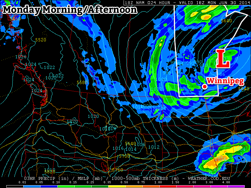
Periods of rain will continue in southern Manitoba on Monday
Monday
Monday
19°C / 10°C
Periods of Rain
Today will be another nasty day in southern Manitoba. The large low pressure system that has been affecting us since Saturday will continue to produce rain today. The intensity of the rain will not be as high as what we saw on the weekend, but many areas could see an additional 5-10mm through the day, with locally higher amounts. It will remain windy as well, with a west to north-west wind at 30km/h gusting to 50km/h.
Tuesday
Tuesday
17°C / 7°C
Chance of Showers
Showery and cool weather will just keep coming on Tuesday. Luckily, it appears significant accumulating rain should be over by this point, with just the odd light shower remaining. However, temperatures will be well below seasonal and it will be windy again. Overall, another nasty day.
Wednesday
Wednesday
23°C / 11°C
Mainly Sunny
It looks like we’ll finally see a break in the weather on Wednesday, as high pressure moves in and skies clear out. Temperatures should be in the low twenties under sunny skies and light winds. It will be a nice day, even if it is still a bit below seasonal for this time of year.
Long Range
Fortunately, given the weather of late, the long range forecast is looking encouraging. Models suggest that we’ll see a warming trend late this week into the weekend. At least for the time being there is no indication of another cool-down in the forecast.
A muggy and increasingly unstable air mass will bring heavy showers and thunderstorms to Southern Manitoba this weekend; the “where” is nigh-impossible to predict.
The last few days has seen increasingly warm and humid air building into the Southern Prairies and today will mark the transition in Southern Manitoba into the new air mass. Unfortunately, the large-scale weather pattern will be very slow-moving and result in several days of showers which, thanks to the ample humidity, will certainly be very heavy at time.
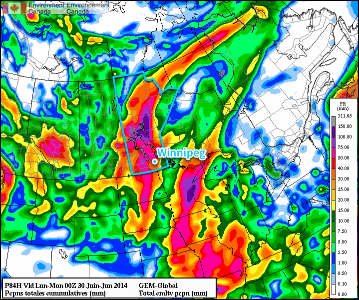
The GDPS is forecasting over 100mm of rain through Manitoba with the upcoming system. We probably won’t see that much. Probably.
Due to the disorganized nature of the showers, it’s impossible to say where exactly is going to see the most rain; that will only become clear as events unfold and each successive round of showers develops. Overall rainfall totals will fall into a huge range; some places may see only 5-10mm or less by the end of the weekend, while others may see anywhere from 50-100mm…or more?
We’ll go day by day and outline the most likely scenarios and what you can generally expect. Due to the high water levels through much of Southern Manitoba, we’ll be a little generous with our “slight risk severe” area due to sensitivity to rainfall (especially large quantities in short duration). We’ll make a small note on our convective outlooks to highlight this as well.
Friday: Heavy Rain in SW Manitoba
Friday
26°C / 18°C
Mixed skies. Thunderstorms likely in the afternoon and overnight. Muggy.
Today’s main threat area will be southwest Manitoba where a combination of the remnants of thunderstorm activity from overnight will be moving through this morning and more thunderstorm activity will develop this afternoon and spread eastwards.
This morning will bring two possible areas of showers, the first over southwestern Manitoba as the remnants of the overnight storms in Saskatchewan lift north-northeastwards and the second being a slight chance of some shower or thundershower activity in the Red River Valley.
Skies will be mixed through the day as we head to a high of around 26°C as southerly winds bring in significantly more humid air; dew point values will climb above 20°C through the afternoon, making it feel positively muggy out there.
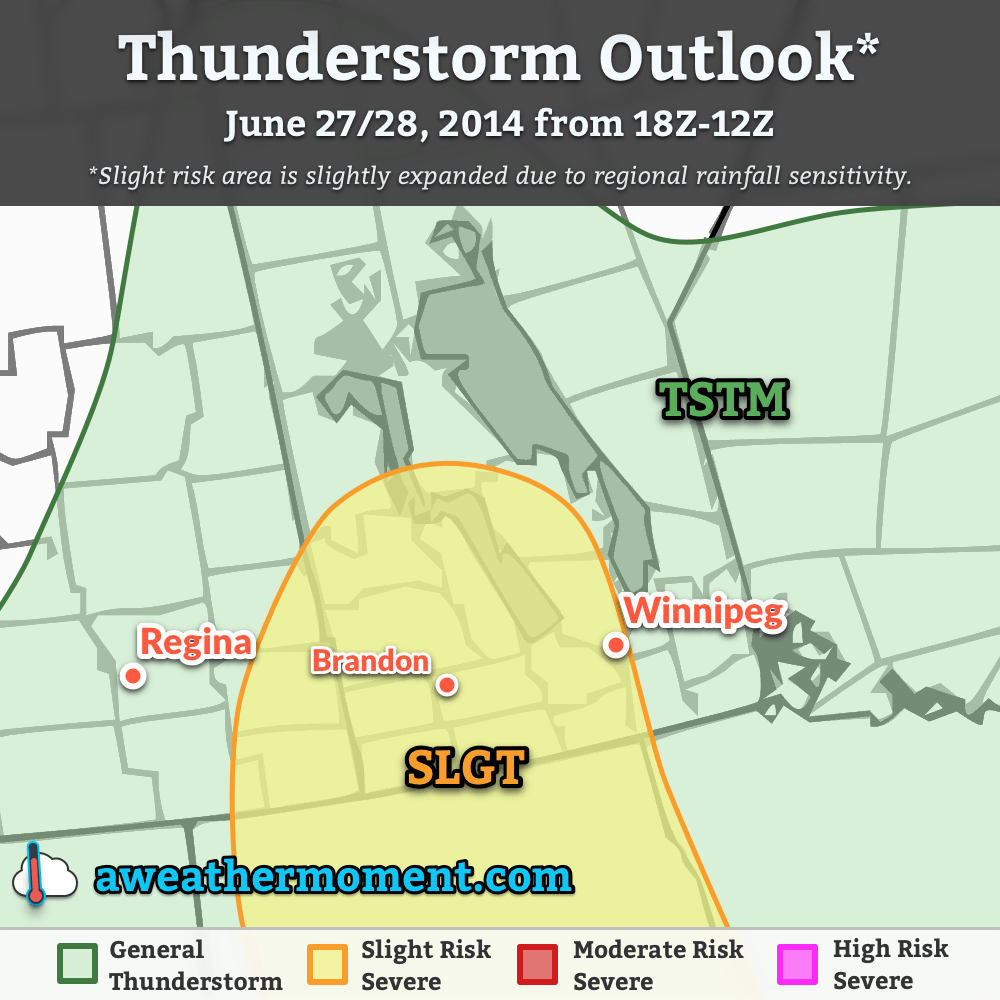
Thunderstorm outlook for June 27 & 28, 2014 for 1PM CDT through 7AM CDT.
Thunderstorms will redevelop this afternoon over SW Manitoba and spread eastwards through the evening. The main threat from the thunderstorms today will be heavy rain thanks to elevated precipitable water values and likely slow storm motion. Back-building thunderstorms are entirely possible too, which would result in very local areas seeing torrential rains and flash flooding. Marginally severe hail is possible, but the threat would likely be limited to the earlier storms in the day. Other than that, little severe weather is expected. There is a slight chance of funnel clouds over SW portions of the province thanks to relatively high vorticity values ejecting from the base of the incoming upper-level trough and somewhat favourable low-level winds, but conditions don’t look favourable for the development of tornadoes.
The thunderstorm activity will expand into heavy shower activity as well overnight as things push eastwards and northwards. Rainfall totals will be highly variable, with some places seeing nothing and others seeing potentially more than 50mm. The heavy rain concern will shift into the Red River Valley for the overnight period. The low will be around 18°C.
Saturday: Wet Weather
Friday
25°C / 18°C
Cloudy with showers or thunderstorms, heavy at times.
Saturday looks to be the wettest day as a low pressure system lifts northwards out of North Dakota into Southern Manitoba, spreading showers throughout much of the southern portions of the province.
The break between tonight’s convection and Saturday’s weather will be short lived as showers — perhaps with some embedded thunderstorms — lift northwards out of the Dakotas into Southern Manitoba. The showers or thunderstorms will be heavy at times and will likely not taper off until closer to the evening. Rainfall totals will wind up somewhere between 10mm and 50mm, highly variable across the region.
The clouds will begin to scatter out overnight, although complete clearing isn’t likely until Sunday. The low will be near 18°C.
Sunday: A Reprieve
Friday
25°C / 14°C
We’ll see the sun!
Sunday will provide a reprieve from the drenching of the first half of the weekend. The rain activity will remain further north through the northern Interlake and regions adjacent, while further south we see the sun finally make an appearance. Things look dry through the day, although cloud and showers may push through Southern Manitoba through the night as a trough rotates through the region on the back-side of the main low pressure centre.
Winds will be breezy out of the west or southwest on Sunday at around 30-40km/h with gusts to 50-60km/h on top of that. The high will be near 25°C and the overnight low near 14°C.
Cooler Weather Returns for Next Week
Temperatures will return to slightly below normal as cooler air begins to filter southwards on the back-side of the low. Daytime highs will generally be in the low-to-mid 20’s with little chance of rain through the first half of the week.
Temperatures will be on their way up as a warmer, more humid air mass begins moving in from the south, but ample cloud will keep sunshine relegated to “rare resource” status.
The cooler weather of the first half of the week is on it’s way out as a broad trough pushes across the Prairies. A southerly flow will spread through Saskatchewan and Manitoba today which will begin tapping into both warmer and more humid air pushing northwards through the American Plains.
The Canadian forecast model shows the muggy air expected to move in by Friday.
The warmer and more humid air will, unfortunately, also result in more unsettled weather bringing plenty of cloud to the region. Multiple disturbances tracking into the region by week’s end will also result in the return of thunderstorm activity.
Wednesday
20°C / 14°C
Mostly cloudy with a chance of midday showers. Clearing overnight.
Thursday
25°C / 16°C
Increasing cloudiness in the afternoon. Chance of showers overnight.
Friday
26°C / 17°C
Mainly cloudy with showers or thunderstorms.
Another Cool, Cloudy Day
Today will be cool and mostly cloudy through much of the Red River Valley. A few sunny breaks may develop this morning, however with daytime heating more clouds will likely be generated to take their place. There is a slight chance of some showers in Winnipeg and the rest of the Red River Valley beginning late this morning through the afternoon, but anything that develops looks to be fairly light. The high today will be around 5°C below normal at 20°C.[1] Winds will gradually shift from northeasterly this morning to southeasterly by the end of the day, remaining relatively light throughout.
Skies should clear out a fair amount on Wednesday night as temperatures dip to a low near 14°C.
Warmer, Unsettled Weather Moves In
Thursday will be the transition day for the Red River Valley into a warmer, more humid air mass. The day will likely start off mostly sunny – or perhaps a high overcast – with winds out of the southeast increasing to 20-30km/h. The temperature should reach around 26°C, however more notable will the rising dew point[2] which should reach around 17°C by the end of the day. While not too high, the extra humidity will definitely be noticeable by the evening.
Total precipitation forecast by the GDPS for Thursday evening to Friday morning.
In addition to the rising humidity, cloud cover will spread into the Red River Valley from as a trough works its way into southwestern Manitoba. Showers and thunderstorms will be likely over southeastern Saskatchewan and southwestern Manitoba late in the afternoon and into the evening. Although it appears that the worst – and more likely to be severe – weather will remain in Montana and North Dakota, an isolated severe thunderstorm cannot be ruled out, particularly in SE Saskatchewan.
The afternoon storm activity will weaken after sunset but likely continue through the night pushing eastwards and northwards. There will be a fairly good chance of some shower or thundershower activity tomorrow night through most of the Red River Valley; no severe weather is expected at this point. Thanks to the more humid air, the overnight low will sit around 17°C.
Stormy Friday
Friday will mark a return to wetter weather as a low pressure system lifts northwards out of North Dakota through the Red River Valley, bringing with it a surge of warm, muggy air. Temperatures will climb into the high 20’s – likely around 26 or 27°C – while the dew point rises to around 21 or 22°C, making it feel very muggy.
Thursday’s overnight activity may be lingering in the morning, but it looks quite likely that things will become unstable late in the morning or early in the afternoon again, bringing more shower and thunderstorm activity. It’s still a little early to make very specific predictions, but if things pan out the way it looks now, there would be a very slight chance of severe thunderstorms in the Red River Valley with the main threats being torrential rain causing flash flooding[3] and large hail. We’ll be refining our convective outlook closer to the event since small changes between now and then – particularly with the night-time storms – can dramatically alter the forecast.
Friday night will be cloudier than not with an overnight low of 17°C. It looks fairly likely that a line of thunderstorms will develop through North Dakota along a weak cold front and track northeastwards through the overnight period. At this point it looks like that system will continue to bring a risk of thunderstorms to the Red River Valley through much of the night, but the best support for severe weather looks to remain in North Dakota/Minnesota.
Unsettled Weekend
The unsettled weather will continue through the weekend as yet another upper low begins building into the Prairies (the third in as many weeks). Saturday will likely see showers and thundershowers to the east and north of the Red River Valley to start the day. Much of the day may end up being fairly pleasant, so if that materializes get out and enjoy it!
A shortwave is forecast to move across the province on Saturday night, likely bringing another outbreak of thunderstorm activity. Severe weather may be possible.
Sunday looks to be a nice day, with the sun likely finally making an appearance and a high near the mid-20’s. The humid air should be off into Ontario by Sunday, so it will likely be quite a comfortable afternoon here in the Red River Valley.
Unless a little more sun develops, then we may see 21 or even 22°C before showers take over. ↩
Dew point is a measure of how much water is in the air. Compared to relative humidity, it’s a more consistent representation of how humid it is. ↩
Which wouldn’t be particularly difficult, given the high water levels already in place. ↩
We’ll see cooler weather to start the week alongside some more shower activity as the upper low that has plagued the region for the past week finally makes an exit.
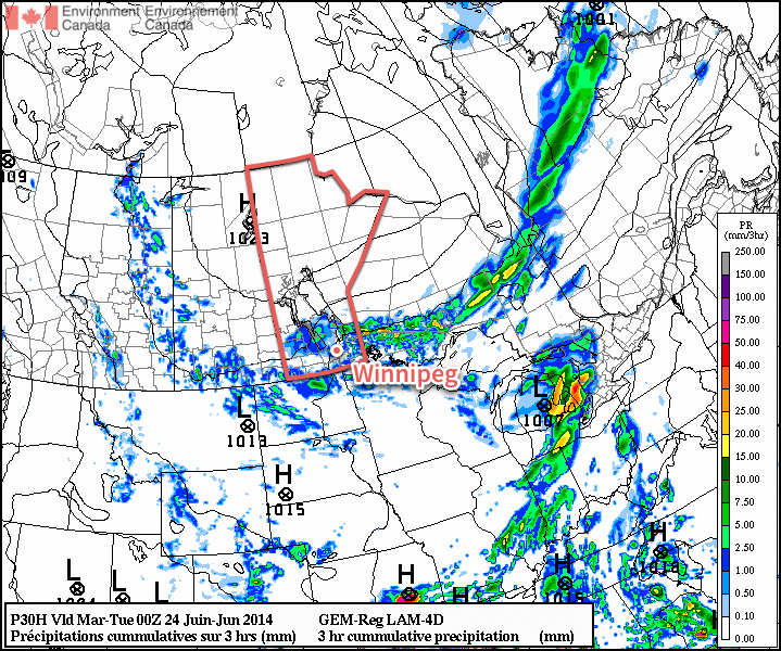
More organized shower activity is expected today throughout much of Southern Manitoba.
Monday
Monday
20°C / 12°C
A mix of sun and cloud with showers.
Today will feature below normal temperatures and a good chance of rain. Shower activity should pop-up relatively quickly during the day as daytime heating destabilizes the atmosphere. High temperatures will be near 20C with a light west wind shifting to northerly in the afternoon.
Tuesday
Tuesday
19°C / 10°C
A mix of sun and cloud with a slight chance of showers.
Tuesday will see temperatures cool a bit further from Monday’s values. High temperatures will be in the upper teens, with a slight chance of showers sticking around. The wind will be breezy and from the north.
Wednesday
Wednesday
22°C / 12°C
A mix of sun and cloud with a slight chance of showers.
Wednesday will see little change from the previous two days. Temperatures will warm slightly from Tuesday, with highs into the low twenties, but a slight chance of showers will remain.
Long Range
We should see temperatures rebound to normal or above-normal values by week’s end. In addition to the warmer weather, models are also indicating that more humid air will return and we may even head into the first multi-day hot and humid event of the summer.
Models also hint at the risk of strong thunderstorms returning by next weekend, but it’s too soon to say for sure.