We’ll have to deal with a few more days of frigid weather before a warming trend begins to take hold.
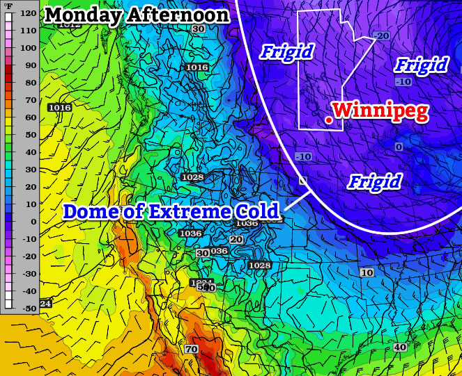
Extremely cold air will remain entrenched over Southern Manitoba today.
Monday
Monday Mainly Sunny -28°C / -32°C
Today will start out with extreme cold yet again. Low temperatures this morning will be in the minus thirties, though values will be closer to -30C than -40C. Afternoon temperatures will warm little, with temperatures “rising” into the upper minus twenties. Unfortunately, the wind will be quite a nuisance today, generating wind chills in the -40s once you factor in north-westerly winds of 20-30km/h. The mercury will plummet once again tonight, with lows in the minus thirties expected.
Tuesday
Tuesday Mainly Sunny -22°C / -30°C
Tuesday will be a slightly nicer day than Monday. The main improvement will be lighter winds, which will make it feel more like the actual air temperature. But those air temperatures will remain very cold, with highs once again being well into the minus twenties.
Wednesday
Wednesday Mainly Sunny -21°C / -25°C
Wednesday will remain very cold, with morning temperatures near the minus thirty mark, and daytime highs being near the -20C mark. The wind doesn’t look to be particularly strong, so like Tuesday it will feel close to what the air temperature indicates.
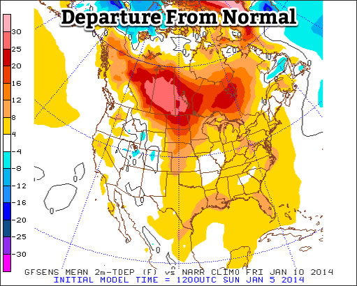
Warming in the Long Range?
The GFS model suggests we will see above normal temperatures by the end of the week.
The long range is where the light begins to appear in the tunnel. Models suggest that we’ll do better than -20C on Thursday as a warmer air mass begins to move into Southern Manitoba. However, this advancing air mass will be accompanied by strong southerly winds, which will cause Thursday to remain a fairly chilly day. However, by Friday into the weekend it appears that we’ll begin to see high temperatures consistently be in the low minus teens or minus single digits. Models don’t show any major cold snaps returning in the foreseeable future, but there will still be colder days here and there. The bottom line is that a prolonged period of warmer weather is finally on the way – time to pop the champagne!
Snow will the the story today as another system moves across Manitoba bringing close to 10cm to Winnipeg and lesser amounts southwards towards the International Border. The warm temperatures that we’ll see today will quickly be replaced by one of the most unpleasant cold snaps of the year; while temperatures won’t be the coldest we’ve seen, they’ll be coupled with a strong wind that will produce some of the coldest feeling weather of the winter.
Friday -11°C / -23°C 5-10cm of snow. Windy with blowing snow in the morning and evening.
Saturday -22°C / -33°C Sunny, windy and very cold.
Snowfall accumulations aross Southern Manitoba; totals for the period of Thursday night through Friday evening.
Snow will be the story today as a pair of low pressure systems move in tandem through Manitoba; one in the Northern half of the province and the other travelling near the United States border. They will work together to produce an extremely wide swath of snow that covers nearly the entire province. The heaviest snow will track through the “usual” suspects: Parkland Manitoba (particularly near Dauphin) SE through the Southern Interlake and then off towards Pinawa and into NW Ontario.
Along the axis of heaviest snow, around 10–15cm will fall, with the higher amounts closer to the Ontario border thanks to the merging of the two low pressure systems. Winnipeg will sit right on the southern edge of the axis of heaviest snow, so we’ll likely see total amounts by this evening very close to 10cm. Amounts will taper off relatively quickly as one goes south; areas near the U.S. border will see only around 2–5cm of snow.
In tandem with the snow will be mild temperatures and strong winds. Here in Winnipeg the temperature will climb to a comparatively balmy –11 or –10°C while temperatures in the Southern Red River Valley may see as high as –5 or –4°C. These warm temperatures will be ushered in by the strong winds we’re seeing this morning out of the south at around 40km/h with gusts to 60km/h. This wind will produce blowing snow in open areas of the Red River Valley this morning which will produce near-zero visibilities. As is usual, highways running west-east will be hardest hit. The wind will taper off midday and we’ll see a fairly pleasant afternoon with some light snow, mild temperatures and light winds.
Things will deteriorate quickly in the evening as the cold front slumps southwards. Extremely cold air will begin pushing into the Red River Valley as winds pick up out of the northwest to 30–40km/h with gusts as high as 60km/h. This, combined with the freshly fallen snow, will produce widespread blowing snow through much of the Red River Valley through the evening and overnight hours. Visibilites will be near-zero in some areas and, in general, highway travel will be difficult. If you need to travel tomorrow night, carry a winter survival kit and give yourself lots of time to reach your destination.
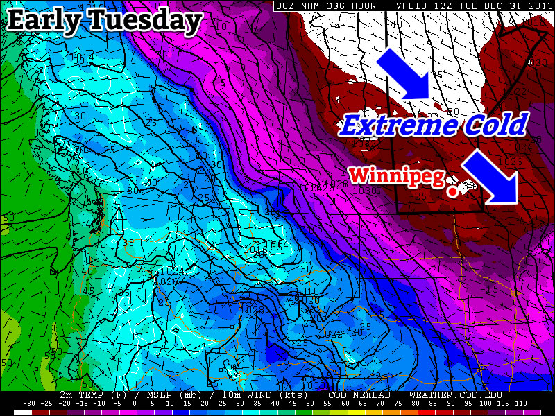
Brutal Cold Returns for the Weekend
The GDPS 850mb temperatures show an extremely cold Arctic air mass moving over Southern Manitoba this weekend.
After the snow and wind moves out tonight, we’ll be left with absolutely brutal cold moving into the region. Although the temperatures won’t be quite as cold as the last shot we got, they’ll be paired with winds in the range of 15–30km/h which will make it feel significantly colder. The temperature will slowly fall all day Saturday from whatever it is in the morning (close to –22°C or so) until we hit our overnight low on Saturday night of around –33°C. Combined with the wind, it will feel closer to around –45 by early sunday morning.
Sunday will see temperatures recover to around –26°C thanks to a little bit of cloud pushing back into the region from the north. Winds will be 15–20km/h mainly out of the west. We’ll drop to around -32°C on Sunday night under mainly clear skies.
Happy New Year! Hope you didn’t expect any significant shift in our weather pattern because the cold air is here to stay. A brief reprieve may be seen as a system slides through by week’s end, but the cold air is set to return behind it.
Wednesday -27°C / -34°C Mainly sunny; cold.
Thursday -24°C / -26°C Mainly sunny. Increasing cloud with a chance of light snow overnight.
Friday -14°C / -25°C Periods of light snow, 2-5cm. Clearing overnight.
We’ll see another very cold day today with any remaining clouds clearing out this morning as we march towards a daytime high of just –27°C or so. Temperatures will drop to around –34°C tonight under clear skies. Tomorrow will bring mainly sunny skies and slightly warmer temperatures as a system pushing eastwards into the Prairies begins bringing some slightly warmer air eastwards. Our high should reach around –24°C while the warmer air becomes much more apparent with our overnight low which will be comparatively balmy around –26°C. Clouds will push in overnight with a slight chance of some light snow before morning.
Snow Likely on Friday
Friday will likely bring light snow to Winnipeg as a low pressure system works through Manitoba. The bulk of the snow will through the Interlake into Central Manitoba, but we’ll likely see the white stuff here in the Red River Valley as well. It looks like most places will see around 2–4cm of snow, however it’s possible that we sneak into the 5–8cm range if things end up just a little heavier than currently forecast. At this point, it looks like Winnipeg would likely see 4–5cm of snow; we’ll be sure to update this if need be as the system gets closer.
A benefit to the cloud and snow will be warmer weather; temperatures should climb to around –14°C on Friday. Skies will clear overnight and we’ll drop down into the mid-minus twenties.
Cold Air Returns
Yet another shot of extremely cold Arctic air is set to move back into Manitoba behind this system. Daytime highs will likely sit in the mid-minus 20’s through the weekend with overnight lows near –30°C, but the cold air should work it’s way into the region early next week, bringing another round of extremely cold temperatures.
2013 In Review
As it’s now 2014, I’ve already begun working on the 2013 statistics for Winnipeg. I hope to have a post ready within a couple weeks with a complete summary of the year past that will put into perspective where last year sat in the big picture!
December will end just as it began – COLD. The New Year will be ushered in by frigid temperatures, with no end in sight to the big cold.
It will be extremely cold to start the week.
The Week Ahead
Monday Mix of Sun and Cloud -27°C / -37°C
Tuesday Increasing Cloudiness -28°C / -34°C
Wednesday Clearing late -23°C / -34°C
Monday
The cold poll outcome.
Today will be just another cold day. Luckily the wind won’t be particularly strong, though that’s little consolation. Tonight will be extremely cold, with low temperatures near -40C not out of the question in some traditional cold spots. It doesn’t look like Winnipeg will hit the -40C mark, but it could be close.
With extremely cold temperatures on the way tonight, take part and guess exactly how cold it’s going to get!
Tuesday
After a very cold start to the morning on Tuesday, it won’t warm up much. High temperatures are expected to remain near -30C, but winds will remain light as we languish under a strong surface high pressure system.
Wednesday
Temperatures may rise a bit from Tuesday evening into Wednesday morning as some cloud cover moves in. However, Wednesday will remain quite cold, with high temperatures still in the minus twenties. The wind will once again remain light, which about about the only good thing that can be said about the weather early this week.
Long Range
The long range outlook continues to look very ugly indeed. I have few positive things to say on this topic, so I’ll just leave it at that.