Warm Start to the Week

This week will start out seasonably warm, a nice turn-around after a cool end to last week.

The Weather will be Nice in Southern Manitoba on Monday

The Week Ahead

Monday

Mainly Sunny
16°C / 6°C
Tuesday

Mix of Sun and Cloud
20°C / 6°C
Wednesday

Mainly Cloudy
16°C / 7°C

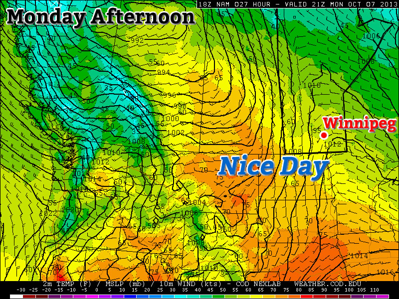
Today will be a nice day in Southern Manitoba. Temperatures will be in the mid teens under sunny skies. The wind will be light as well, making for all around pleasant conditions.

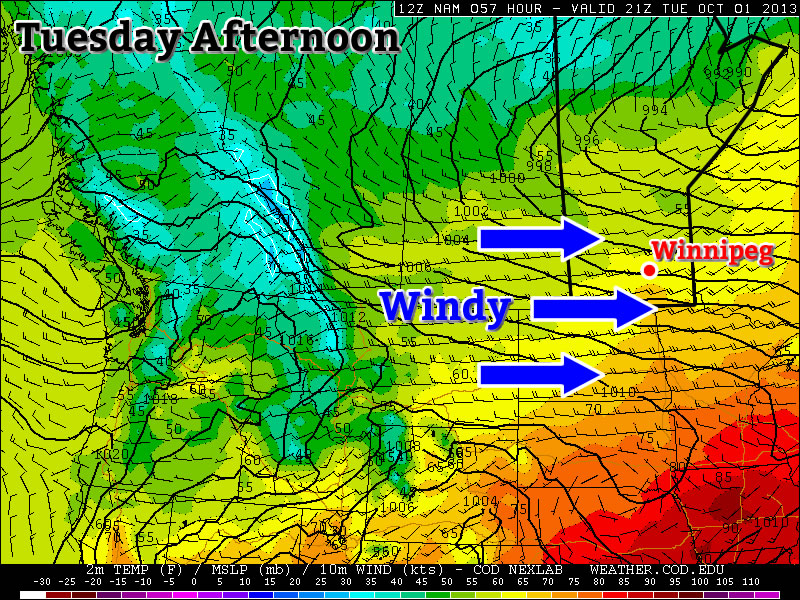
Tuesday will once again see mild conditions in Southern Manitoba. There may be a bit more cloud compared to Monday, but temperatures are still expected to be warm, with highs in the upper teens or low twenties. Tuesday will be a bit windier than Monday, but even so the wind won’t be a big issue.

Conditions will change little for Wednesday. Temperatures will once again be in the mid teens in Southern Manitoba with light winds. Wednesday will be a cloudier day however, as a weather system to our south spreads some cloud cover over Southern Manitoba.

Long Range

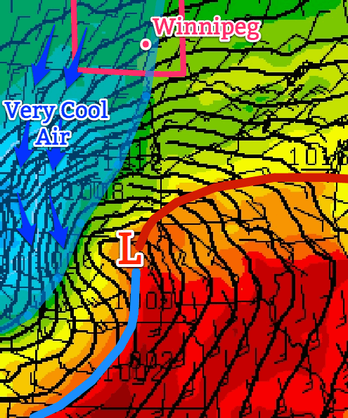
The weather for the late week period is looking a bit interesting. A large low pressure system is currently forecast to move through Southern Manitoba towards the weekend. At this point it appears precipitation from this system will be mostly rain, although some flurries may be possible as it exits the region. More details on this system will be available later in the week.

Uneventful and Cooler End to the Work Week

A strong low pressure system located to our south-east, in the Northern US Plains, is expected to bring the Dakotas their first snowfall accumulation for the 2013-2014 winter season but will only clip portions of extreme south-east Manitoba.

US Plains low

Low pressure system affecting Northern Plains depicted here for 4PM CDT today. It will keep us cool and cloudy for most of the afternoon/evening.

Friday

Friday

8°C / 1°C
Becoming overcast early on in the day.

Today, temperatures will be slightly on the cool side. The strong system aforementioned will be drawing in cooler air from the north into southern Manitoba. Models are in agreement that rain and snow will stay out of Winnipeg, though there is a slight chance that regions in extreme south-east Manitoba get some showers Friday evening. Winnipeg can expect to see a high near the 8°C mark with increasing cloudiness throughout the day. In the afternoon and evening winds will be stronger 20km/h gusting to 40km/h coming out of the north. It will be a notably chilly day; our high will be some 7-8°C below normal for this time of year. West of the Red River Valley will be even chillier with highs only expected in the mid-single digits. For Friday night, there is a small chance of frost in Winnipeg but areas more at risk lie to the west of the city.

Saturday

Saturday

10°C / -1°C
Mainly sunny.

Saturday looks to be a nicer day, compared to today; mostly sunny skies combined with slightly higher temperatures around 10°C. The only potential downfall looks to be the wind which will still be fairly strong in the afternoon: 20-30km/h from the north before it dies down in the evening. Saturday night will be a chilly one with high pressure in our region, light winds and clear skies for the most part; Winnipeg has a good chance at seeing some frost.

Sunday & Beyond

Sunday

13°C / 4°C
Mainly sunny, a few stray clouds.

The weekend looks to end on a good note with mainly sunny conditions under more of a westerly flow. Highs in the low to mid-teens can be expected for southern Manitoba. Winnipeg looks to see a return to seasonal temperatures with a high of around 13°C weaker winds than the past few days.

For the beginning of the next work week temperatures appear to stay near normal as high pressure moves in. As the high pressure system moves east, a return flow will likely bring in some warmer, above normal, temperatures to the Red River Valley by Tuesday.

Cooler Weather Settling In

After a windy day yesterday, Southern Manitoba will see cooler weather through the remainder of the week as a fairly seasonal air mass sits anchored over the region. While cool, things will remain dry as any showery weather remains locked up in Central Manitoba & the Northern Interlake.

The Next Few Days

Wednesday

16°C / 3°C
Some cloudy periods.
Thursday

16°C / 3°C
Partly cloudy.
Friday

10°C / 2°C
Increasing cloud, cooler.

Today and tomorrow will be essentially carbon copies of each other. Highs will sit around 16°C with overnight lows near 3°C. Winds are expected to be fairly light both today and tomorrow. Both days will have some cloud around; today we’ll see some cloud pushing up from North Dakota through the Red River Valley while tomorrow we’ll see some cloud slumping southwards from the Interlake. While there may be some light shower activity with the cloud pushing southwards from the Interlake, at this point the entirety of it is expected to remain west of the Red River Valley in the Riding Mountain region slumping southwards into SW Manitoba.

Things will cool off a bit on Friday in the Red River Valley as an intensifying low pressure system in South Dakota/Minnesota draws cooler air from the north into the Red River Valley through the day. Any rain this system produces will remain south of the Canada/U.S. border in the Dakotas and Minnesota. We’ll see some cloud push into the Red River Valley through the day thanks to this system. Exactly who will see cloud and who won’t will be tough to call; the cloud will likely have quite a sharp edge thanks to a strong deformation zone. It will be fairly safe to say that places such as Steinbach and areas SE will end up overcast by day’s end while areas west of Winnipeg, such as Portage la Prairie, will likely remain fairly sunny. Here in Winnipeg we’ll likely sit somewhere near the edge of the edge of the cloud by day’s end.

Looking to the Weekend

The weekend looks fairly quiet over much of Southern Manitoba. Benign weather will dominate over SW Manitoba, things should remain fairly calm over the Red River Valley and the SE portion of the province will see a shot of getting some rain.

An area of rain looks to push northwards out of North Dakota and Northern Minnesota as a developing low lifts NE out of Minnesota on Friday night. The area of rain will have a very sharp edge on it’s northwestern flank thanks to the aforementioned strong deformation zone. Most models are keeping all of the rain in the United States, however some higher-resolution long-range and medium-range models are starting to creep the system a little further west and introduce some rain activity into SE Manitoba on Saturday, likely through the Sprague region. At this point, I’d say that the region has just a slight chance of some rain.

The Red River Valley looks to remain completely clear of the rain for this system with mostly clear skies and cool-to-seasonal temperatures.

October Won’t Have a Scary Start

October won’t start off with any scary weather, but I can guarantee the month will end on a frightening note!

Tuesday Will be a Very Windy Day in Southern Manitoba

Monday

Monday

Mix of Sun and Cloud. Chance of Showers Late.
22°C / 8°C

Today will be a nice day in Southern Manitoba. Temperatures will be in the low twenties, under a mix of sun and cloud. The wind will be breezy and from the south-west. A cold front will push through Southern Manitoba on Monday night, setting up a cooler Tuesday. There may also be some light rain showers associated with this front, but it will be a hit and miss type of rain event.

Tuesday and Wednesday

Tuesday

Increasing Cloudiness
17°C / 4°C
Wednesday

Mix of Sun and Cloud
15°C / 6°C

The first day of October will neither be really good, nor really bad. On the one hand it will be a seasonably warm day, with temperatures in the mid to upper teens. However, it will also be a very windy day, with westerly winds of 40-50km/h gusting to 60-70km/h (winds may reach 60km/h gusting to 80km/h on a localized basis). Unfortunately, that strong wind will make conditions much less pleasant than they otherwise would be.

Wednesday looks to be much less windy than Tuesday, but it will still be on the breezy side. Temperatures will be in the mid teens, with a westerly wind of 20-30km/h gusting to 40-50km/h.

Long Range

The long range forecast is looking more October-like. Another cold front is currently forecast to move through Manitoba on Wednesday night, bringing in cooler conditions to end the week. Models are also hinting at a strong low pressure system passing near or just south of Manitoba later this week. Should this system take a more northern track, it could impact Southern Manitoba…but it’s too early to say.