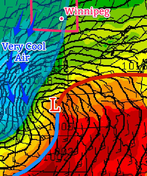
A strong low pressure system located to our south-east, in the Northern US Plains, is expected to bring the Dakotas their first snowfall accumulation for the 2013-2014 winter season but will only clip portions of extreme south-east Manitoba.
Friday
8°C / 1°C
Becoming overcast early on in the day.
Today, temperatures will be slightly on the cool side. The strong system aforementioned will be drawing in cooler air from the north into southern Manitoba. Models are in agreement that rain and snow will stay out of Winnipeg, though there is a slight chance that regions in extreme south-east Manitoba get some showers Friday evening. Winnipeg can expect to see a high near the 8°C mark with increasing cloudiness throughout the day. In the afternoon and evening winds will be stronger 20km/h gusting to 40km/h coming out of the north. It will be a notably chilly day; our high will be some 7-8°C below normal for this time of year. West of the Red River Valley will be even chillier with highs only expected in the mid-single digits. For Friday night, there is a small chance of frost in Winnipeg but areas more at risk lie to the west of the city.
Saturday
10°C / -1°C
Mainly sunny.
Saturday looks to be a nicer day, compared to today; mostly sunny skies combined with slightly higher temperatures around 10°C. The only potential downfall looks to be the wind which will still be fairly strong in the afternoon: 20-30km/h from the north before it dies down in the evening. Saturday night will be a chilly one with high pressure in our region, light winds and clear skies for the most part; Winnipeg has a good chance at seeing some frost.
Sunday & Beyond
13°C / 4°C
Mainly sunny, a few stray clouds.
The weekend looks to end on a good note with mainly sunny conditions under more of a westerly flow. Highs in the low to mid-teens can be expected for southern Manitoba. Winnipeg looks to see a return to seasonal temperatures with a high of around 13°C weaker winds than the past few days.
For the beginning of the next work week temperatures appear to stay near normal as high pressure moves in. As the high pressure system moves east, a return flow will likely bring in some warmer, above normal, temperatures to the Red River Valley by Tuesday.