Far from the sunny skies and warm temperatures we’ve seen constantly over the last several months, today will be cold, wet and windy as a cold front blasts through the Red River Valley.

850mb temperatures from the GEM-REG model valid for this evening. A significant outbreak of cold air will occur over Southern Manitoba today.
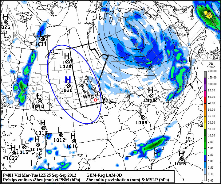
A powerful cold front will push southwards through the Red River Valley today, beginning in areas north of Winnipeg early this morning, then pushing through Winnipeg mid-to-late morning and then pushing through the rest of the valley and southeast Manitoba by early this afternoon. There will be an area of showers that pushes through the central and eastern Red River Valley, with rain further east in the Whiteshell along and behind the cold front. Generally speaking, if you’ve seen showers in the past two days, you’ll likely see more today. Winnipeg will likely only see 1-2mm, however anywhere from 2-10mm are possible in the eastern Red River Valley to the Ontario border. In addition to the precipitation, strong winds will once again develop over the Red River Valley, with winds increasing out of the north to 40-50km/h with gusts to 60-70km/h immediately behind the cold front.
This system will be dragging the coldest temperatures aloft that we’ve seen this month; 850mb temperatures will drop to anywhere from -5 to -8°C. This will result in fairly significant low-to-mid-level instability, mainly through the Interlake and arcing southeastwards across the South Basin towards Sprague. This will have two main impacts:
- Today, associated with the passage of the cold front, there’s a chance for an isolated thundershower through the Central/Southern Interlake and the Dugald/Beausejour/Grand Beach region. They will not be very strong, however they may be able to produce small hail.
- As the winds at various heights in the atmosphere slowly line up, lake-effect streamers will develop this evening and overnight off of Lake Winnipeg. The location of the precipitation will be sensitive to the exact wind direction, however, in general, the regions that will be effected the most will be up in the Arborg area (from the North Basin), and then further south in the Dugald/Beausejour/Grand Beach region (from the South Basin). There will also likely be streamers in the Portage la Prairie region overnight from Lake Manitoba, however they’ll be weaker as a surface ridge approaches from the west overnight. There will only be a slight chance of isolated showers in the southern half of the Red River Valley overnight. Winnipeg will be nestled between the two bands of streamers to our west and east, however there’s a distinct chance that we could see the streamer from the South Basin move into the city overnight.
In addition to the streamers, the other significant weather tonight will be frost. Areas that clear out tonight, which will be most areas that aren’t in the lee of the lakes, will see frost with overnight lows in the -1 to -3°C range. There’s a chance that areas in SW Manitoba may see overnight lows dip as low as -5°C underneath the surface ridge.
For Saturday, here in the valley we’ll see clouds & showers from the lakes last until midday before things start to clear up in the afternoon. Temperatures will remain cool with highs only around 11°C. We’ll likely see a hard freeze tomorrow night with overnight lows in the -3 to -5°C range across most of Southern Manitoba.
On Sunday, we’ll finally see some warmer air make it’s way towards us. The models want to push temperatures as high as 18-19°C through the Red River Valley, however we often see cold air stick around a little longer than forecast. Winds are forecast to shift to the southwest, however it’s almost certain that if they don’t quite make it to SW and end up being southerly we’ll see daytime highs a few degrees cooler than that. We should see temperatures in the mid-to-upper teens last through much of next week with little significant weather on tap.